
Feels-like temperatures in the 20s in parts of Central Florida
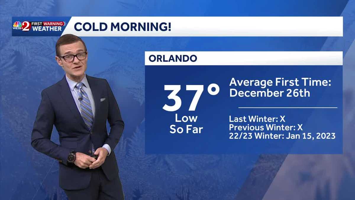
UNDERGROUND ELECTRICAL CONDUIT. 516 LET’S CHECK IN WITH FIRST WARNING METEOROLOGIST ERIC FIRST. NOW WE’RE TALKING IMPACT WEATHER TODAY. GUYS, I KNOW THAT THESE ARE SERIOUS COLD CONDITIONS, BUT AT THE SAME TIME, WE HAVEN’T FELT THIS IN SO LONG AND IT FEELS SO REFRESHING. IT FEELS LIKE SOMETHING. YEAH, I MEAN REFRESHING. AS LONG AS YOU’RE BUNDLED UP APPROPRIATELY. RIGHT. BUT LIKE LET’S TALK ABOUT THIS BECAUSE THIS IS SO INTERESTING. SO WE’VE NOW MADE IT DOWN TO 37 LOOKING AT THE HISTORY BOOKS, THE AVERAGE FIRST TIME WE GET THERE IS DECEMBER 26TH. SO AROUND CHRISTMAS. DIDN’T GET THERE LAST WINTER, DIDN’T GET THERE THE PREVIOUS WINTER. THE LAST TIME WE WERE IN THIS TEMPERATURE RANGE WAS JANUARY 15TH, 2023. SO AT LEAST IN ORLANDO, THIS IS THE COOLEST TEMPERATURE THAT WE HAVE SEEN IN YEARS. AND TO PUT IT MORE INTO PERSPECTIVE, WE’RE AT 3837 RIGHT NOW. IT’S COLDER HERE THAN BANGOR, MAINE. OKAY. TO PUT THAT INTO PERSPECTIVE, IT’S COLDER IN CHICAGO, BUT YOU GET THE IDEA. 51 RIGHT NOW IN BILLINGS, MONTANA. SO IT’S COLDER HERE. YEAH. ISN’T THAT SOMETHING. ALL RIGHT LIV TEMPERATURE NOW 37 IN THE CITY. IT’S 35 IN LEESBURG, 36 IN THE VILLAGES. AND EVEN ALONG THE SHORELINE. IT’S CHILLY. 37 DAYTONA BEACH, 40 DEGREES IN TITUSVILLE, 41 IN PALM BAY. FEELS LIKE TEMPERATURES ARE IN THE 20S FOR JUST ABOUT ALL OF US. BECAUSE OF THIS WIND, IT IS HOWLING, SUSTAINED TEN, 15, NEARLY 20. BUT LOOK AT THE WIND GUSTS JUST IN THE LAST HOURS TIME 20, 30, 35 MILES AN HOUR. SO THIS IS A DAY. IT’S NOT JUST ABOUT THE COATS. YOU WANT THE SCARF. YOU WANT THE BEANIE. YOU WANT THE GLOVES. OKAY. BECAUSE SERIOUSLY, CENTRAL FLORIDIANS ARE NOT USED TO THIS SORT OF THING. SO PLAN APPROPRIATELY FOR THAT MORNING BUS STOP TEMPERATURES OUT THE DOOR. BLUSTERY. OKAY. THIS AFTERNOON IT WILL STAY CHILLY, BUT AT LEAST THE WINDS WILL CALM AND THE TEMPS DO CLIMB A LITTLE BIT THIS AFTERNOON. IT’S 57 IN ORLANDO, 56, ORANGE CITY, 57, IN OVIEDO AND 56 IN OCALA. IT’S A BEAUTIFUL, CHILLY DAY. TEMPERATURES, THOUGH, ONCE THEY GET UP, THEY START TO DROP BACK OFF AGAIN TONIGHT AND LESS WIND IS IN THE FORECAST THIS EVENING, WHICH MEANS FROST IS ABSOLUTELY A CONCERN. 42 IN ORLANDO, 41 IN MAITLAND. THIS LINE HERE IS WHERE WE EXPECT TO SEE THE MOST WIDESPREAD FROST. THESE LIGHT BLUES. OKAY, 38 IN DELAND. NOT NECESSARILY BEACHSIDE, BUT AS SOON AS YOU HEAD INLAND IN VOLUSIA COUNTY. THERE’S YOUR FROST, 37, IN DELTONA, ANTICIPATING TEMPERATURES NORTH MARION TO BE NEAR FREEZING. THAT’S THE LAVENDER COLOR THERE. 31 IN REDDICK TONIGHT, 33 IN OCALA, 36 LAKE PANASOFFKEE NOT REALLY LOOKING AT FROST FOR EAST ORANGE COUNTY OR BREVARD WITH TEMPERATURES THERE INTO THE UPPER 40S. AND WE DO HAVE FROST ADVISORIES POSTED FOR WEST VOLUSIA, FOR LAKE COUNTY AND EVEN COASTAL PORTIONS HERE OF FLAGLER COUNTY. SO IT’S A CHILLY ONE AGAIN TONIGHT. NOT AS COLD, BUT WITH LESS WIND, FROST. ABSOLUTELY A CONCERN THEN IF YOU LIKE IT. WARMER, MID TO UPPER 70S LATE THIS WEEK. APPROACHING 80 THIS WEEKEND.
Feels-like temperatures in the 20s in parts of Central Florida

Updated: 5:59 AM EST Nov 11, 2025
Impact weather this morning because of just how cold it is- and how much wind we’re seeing.Orlando is currently in the lower 40s, with winds gusting up to 30mph. It’s a blustery start to the morning.Tuesday, once we roll through the big chill, with temperatures in the 30s and feels-like temperatures in the 20s, we warm to the 50s. It will be the coolest day in a long while.Over the next few days, we will gradually warm, with temperatures climbing into the lower 80s by the weekend.First Warning Weather Stay with WESH 2 online and on-air for the most accurate Central Florida weather forecast.RadarSevere Weather AlertsDownload the WESH 2 News app to get the most up-to-date weather alerts. The First Warning Weather team includes First Warning Chief Meteorologist Tony Mainolfi, Eric Burris, Marquise Meda and Cam Tran.What is Impact Weather?Impact Weather suggests weather conditions could be disruptive or a nuisance for travel and day-to-day activities.What is a Severe Weather Warning Day?A Severe Weather Warning Day suggests weather conditions that could potentially harm life or property.
ORLANDO, Fla. —
Impact weather this morning because of just how cold it is- and how much wind we’re seeing.
Orlando is currently in the lower 40s, with winds gusting up to 30mph. It’s a blustery start to the morning.
Tuesday, once we roll through the big chill, with temperatures in the 30s and feels-like temperatures in the 20s, we warm to the 50s. It will be the coolest day in a long while.
Over the next few days, we will gradually warm, with temperatures climbing into the lower 80s by the weekend.
First Warning Weather
Stay with WESH 2 online and on-air for the most accurate Central Florida weather forecast.
Download the WESH 2 News app to get the most up-to-date weather alerts.
The First Warning Weather team includes First Warning Chief Meteorologist Tony Mainolfi, Eric Burris, Marquise Meda and Cam Tran.
What is Impact Weather?
Impact Weather suggests weather conditions could be disruptive or a nuisance for travel and day-to-day activities.
What is a Severe Weather Warning Day?
A Severe Weather Warning Day suggests weather conditions that could potentially harm life or property.