
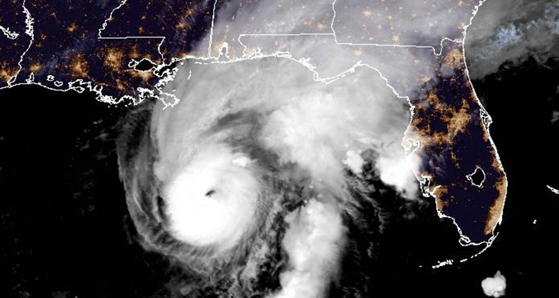
Hurricane Isaias intensified overnight and is now forecast to grow into a major Category 3 hurricane with 120 mph winds today before making landfall tonight on the Florida panhandle, according to the National Hurricane Center.
As of the NHC’s 5 a.m. advisory, the storm was a strong Category 2 hurricane with 110 mph winds, just shy of Category 3 status. It was located about 200 miles south-southeast of the mouth of the Mississippi River moving north-northeast at 15 mph.
“Isaias will likely become a major hurricane soon with the improving satellite imagery, and it could continue to intensify for the next 12 hours or so while it moves over very warm and deep water,” said NHC senior hurricane specialist Eric Blake. “However, a large increase in shear is anticipated before landfall, which will probably cause some weakening to occur.”
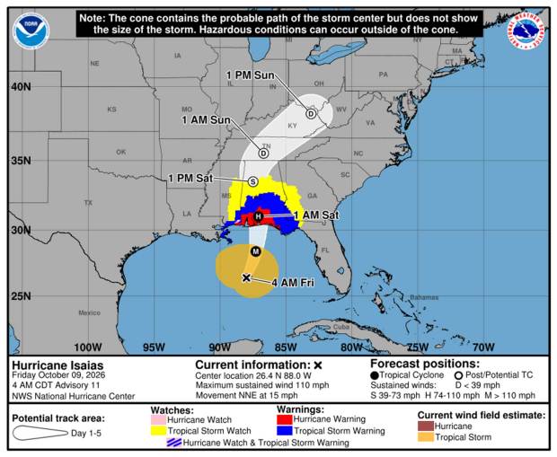 Hurricane Isaias cone of uncertainty as of 5 a.m. Friday, Oct. 9, 2026. (NHC)
The intensity forecast has it growing by 5 p.m. into a storm with 120 mph sustained winds and gusts of 150 mph as its center is still about 150 miles from a projected landfall near Pensacola on the Florida Panhandle. For now, the NHC projects it will drop back down to a strong Category 2 hurricane making landfall late Friday or early Saturday morning.
Blake said that a delay in the wind shear, though, could mean a stronger hurricane could come ashore.
“Regardless of its exact wind speed at landfall, Isaias will be a dangerous hurricane with significant storm surge, damaging winds, and flooding rains,” Blake said. “The wind field is also predicted to grow due to a trough interaction, and some of these impacts will extend well away from the center.”
Hurricane-force winds extend out 30 miles while tropical-storm-force winds extend out 185 miles from its center.
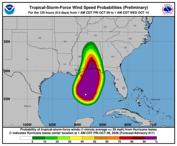 Projected wind field for Hurricane Isaias. (NHC)
A hurricane warning is in effect from Florida’s Bay-Gulf County line west to Ocean Springs, Mississippi with a tropical storm warning in Florida east of the Bay-Gulf County line to the Aucilla River and west of Ocean Springs to the Jefferson-Plaquemines Parish line in Louisiana. A storm surge warning is in effect from the mouth the Mississippi to the Suwannee River in Florida and a storm surge watch farther south to Yankeetown, Florida.
“A life-threatening storm surge is expected from the Mouth of the Mississippi River to Suwannee, Florida. Residents in the warning
area should follow advice given by local officials and evacuate immediately if told to do so,” the NHC warned.
4 AM CDT Fri Oct 9 (Advisory 11) Key Messages for Hurricane #Isaias. Latest info: https://t.co/GrztW6mQJV
4 AM CDT viernes 9 de octubre (Aviso 11) Mensajes clave sobre el huracán #Isaias. Más información: https://t.co/GrztW6mQJV pic.twitter.com/3d2UKzGIlE
— National Hurricane Center (@NHC_Atlantic) October 9, 2026
In addition, some parts of Florida from the Panhandle to the Big Bend could bear the brunt of the most significant rainfall, up to 15 inches as bands of the storm pass over the state. From Friday through the weekend, it’s expected to drop 3-7 inches across the central U.S. Gulf Coast from the Florida Panhandle west to southeastern Louisiana. Another 1-3 inches with up to 5 inches could drop across much of the Southeast U.S. as far north as the Tennessee Valley and Carolinas bringing with it flash and urban flooding with some isolated river flooding.
Hurricane Isaias quickly intensified into a Category 2 storm Thursday having become the season’s first Atlantic hurricane late Wednesday.
Coastal communities moved quickly to prepare. Some Gulf oil wells paused production, and at least four Florida school districts canceled classes for later in the week. Okaloosa County announced mandatory evacuations for some coastal areas, and communities closed government offices as of Thursday afternoon.
Hurricane Isaias tracking map: Here’s the latest forecast and warning areas
Besides wind, the hurricane’s threats include possible tornadoes Friday night in coastal Florida and Alabama, storm surge up to seven feet on parts of the Gulf Coast, and excessive rain.
“Residents in the warning area should follow advice given by local officials and evacuate immediately if told to do so,” the NHC warned.
The storm also will bring heavy swells to Florida’s Gulf Coast with life-threatening surf and rip current conditions.
eGov. Ron DeSantis on Tuesday issued an executive order declaring a state of emergency for 25 Florida counties in preparation for the storm.
“This order will allow the Florida Division of Emergency Management to stage critical preparedness resources and ensure Florida is ready to respond,” DeSantis said in a news release. “Floridians should take this time to get disaster plans in place and ensure their hurricane supply kit is stocked.”
Counties under the state of emergency are Baker, Bay, Calhoun, Columbia, Dixie, Escambia, Franklin, Gadsden, Gilchrist, Gulf, Hamilton, Holmes, Jackson, Jefferson, Lafayette, Leon, Liberty, Madison, Okaloosa, Santa Rosa, Suwannee, Taylor, Walton, Wakulla and Washington.
The system had formed as Tropical Depression Nine on Tuesday, became a tropical storm Wednesday morning and the Atlantic season’s first hurricane at 11:30 p.m. Wednesday, ending the longest stretch without a hurricane since satellite tracking began 60 years ago.
The storm formed just shy of tying a 121-year-old record as the latest arriving initial hurricane of the Atlantic season. According to the National Weather Service, the record dates to 1905, when the year’s first Atlantic hurricane formed on Oct. 8.
The hurricane season had previously seen the formation of tropical storms Arthur, Bertha, Cristobal, Dolly, Edouard, Fay, Gonzalo and Hanna.
For the first time in 60 years, however, none had developed into a hurricane in the Atlantic with less than two months left in the season.
Hurricane season began June 1 and runs through Nov. 30, but the height of hurricane season runs from mid-August through mid-October.
The reason for the lack of hurricanes has been an extremely strong El Niño weather pattern, which is warming surface temperatures in the Pacific Ocean. This generates wind shear preventing storms from strengthening in the Atlantic.
Sammy Hadi, a lead meteorologist with the National Weather Service in Miami, told the South Florida Sun Sentinel last week that the “top of these storms that are developing are being blown off.”
The National Oceanic and Atmospheric Administration in August had updated its seasonal forecast to expect between seven and 13 named storms this year. Of those, two to six would become hurricanes. It also predicted that there might not be any major hurricanes this year, or at most two.
Already, 2026 was forecast to have lower-than-average storm generation, and that has been reduced even further with the latest forecasts from the NOAA and other weather groups.
An average year would see 14 named storms and seven hurricanes, with three of those growing to Category 3 strength or higher.
The Associated Press contributed to this report.