
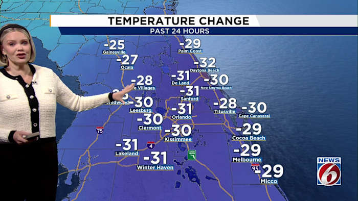
ORLANDO, Fla. – Orlando woke up to an unusually chilly morning Tuesday, with temperatures tumbling nearly 30 degrees compared to the day before.
The sharp drop arrived on the heels of a powerful cold front that swept through the region late Monday.
Highs in the Orlando area on Tuesday are only expected to reach 57 degrees, a stark contrast to the normal high of 79 for this time of year.
If Orlando stays at 57 degrees for the day’s high, it would break the record for the lowest high temperature recorded for this date — 61 degrees in 1913.
[VIDEO BELOW: Winter outlook in Florida]
Frost and freeze warnings
With the cold blast gripping Central Florida, a frost advisory is in effect overnight for northern interior counties like Lake, Volusia and interior Marion.
Freeze warnings remain posted for Marion and Flagler counties through 8 a.m. Wednesday. Patchy frost is likely in these areas, especially where winds relax overnight, so it’s important to cover or move sensitive plants indoors until the warm up arrives.
[VIDEO BELOW: Here’s why we’re so cold in Florida]
Forecast: Warming up
Lows early Wednesday will drop to 42 degrees in Orlando, 30 in Ocala, 35 in Wildwood and 48 in Melbourne.
However, a change is on the horizon.
Temperatures are expected to rebound throughout the week, with highs reaching the low 70s by Thursday and bouncing back into the low 80s by the weekend.
Skies should remain mostly clear and breezy for the next several days, with dry air sticking around thanks to high pressure building over the area.
Looking to share your wild weather photos? Show us what this cold snap looks like in your neighborhood via our PinIt! page.
Copyright 2025 by WKMG ClickOrlando – All rights reserved.