
Record cold temperatures across southwest Florida Tuesday
Temperatures will plummet into the low 40s Tuesday morning with highs only in the 60s.
THEY PERK ARARE RIGHT BACK UP WHEN IT WARMS UP. >> GOING TO BE STUNNING. WEATHER TONIGHT ARE FOR OUR COLDER AREAS. DESOTO CHARLOTTE COUNTY. IT’S POSSIBLE YET AGAIN, THOSE I KNOW THEY’RE IN BAYS OF NICK. FACT. LOOKS LIKE TO HELP AL HAD A BAD ALL RIGHT. WE ARE LOOKING AT TEMPERATURES RIGHT NOW. IT’S GOING TO BE PRETTY CHILLY, ESPECIALLY COMPARED TO THIS TIME YESTERDAY. WHAT’S THAT THE SUN HAS SET AND THE TEMPERATURES WILL CONTINUE TO FALL, BUT WE’RE NOT GOING TO HAVE SUCH A DRASTIC FALL LIKE WE DID LAST NIGHT. SO TEMPERATURES ARE STILL GOING TO BE QUITE COLD FOR HOURS STANDARD TO WHAT WE’RE USED TO BY TOMORROW MORNING. BUT ON THE WAY UP THIS MORNING WAS THE COLDEST THAT WE HAVE TO OFFER. AND THEN WE’LL START TO SEE AVERAGE TEMPERATURES AND THEN SOME BEFORE YOU KNOW ALL RIGHT. TEMPERATURES THROUGHOUT THE NIGHT BY 10 O’CLOCK UPPER 40’S MIDNIGHT. WE’RE LOOKING AT 47 46 DEGREES BY 2 IN THE MORNING. TIME BY TOWN HERE. 43 FOR LEHIGH. THE DIFFERENCE TOMORROW, NOT AS STRONG OF A WIND TO FEEL SOME BLUSTERY AND UNCOMFORTABLE. SO YOU STILL WANT TO DRESS UP. THERE’S STILL GOING TO BE LITTLE BIT OF A BREEZE, BUT WE’RE NOT GOING TO BE SHAVING. A 5, 7 DEGREES FROM FOR THE FEELS LIKE TEMPERATURE FOR THE ACTION FROM THE ACTUAL TEMPERATURE AND TAKE A COUPLE DEGREES OFF HERE TOMORROW MORNING. 49 FOR CAPE CORAL. 51 FOR BOKEELIA. SO MAYBE IF YOU HAVE THE DAY OFF CELEBRATING VETERANS TODAY IN HONORING OUR VETERANS MAY BE KIND OF SKIPPED THROUGH THE COLDEST PARTS OF THE MORNING THIS MORNING. YEAH, WAKE UP TOMORROW MORNING IS GOING TO BE A LITTLE BIT OF A RUDE AWAKENING. UPPER 30’S ARE GOING TO POSSIBLE, BUT MORE LIKELY 40 DEGREES FOR DEEP CREEK AND NORTH PORT. 42 FOR GORDA. THAT’S WHERE WE COULD BREAK ANOTHER RECORD. I MENTIONED EARLIER IN THE IN THE SHOW HERE. GORDA. THE OLD RECORD IS 44 FOR TOMORROW MORNING. THAT’S THE ONLY THAT WE DO HAVE A CHANCE TO BREAK ANOTHER COLD MORNING FOR YOU TOMORROW. 44 IN IMMOKALEE, 53 EVERGLADE CITY GET TO BE IN THE 50’S. THE BELL AT 42 IN CLOSE YOU’LL BE AT 48. HERE’S A LOOK AT THOSE WINDS FOR TOMORROW. MUCH MORE MANAGEABLE NOW THAT THE COLD AIR IS HERE NOW, AS YOU START TO SEE THAT THE TEMPERATURES START TO SLOWLY CLIMB BACK TO AVERAGE THROUGHOUT THE WEEK. SO LIKE I MENTIONED, WE’LL JUST SHAVE OFF A FEW DEGREES TOMORROW MORNING. SO THIS IS REALLY WHAT YOU WANT TO DRESS FOR. NOT TOO DIFFERENT FROM THE ACTUAL TEMPERATURE. 37 FOR ARCADIA. THAT WILL BE ONE OF THE COLDER SPOTS. 41 FOR GATEWAY. 44, THE BELL, 48 FOR NAPLES THROUGHOUT THE NEXT FEW MORNINGS. NOTICE HOW WE DO HAVE THIS NICE LITTLE CLIMB, BUT IT’S STILL KIND OF COOL OUT THERE HIS SAY. 53 IS STILL PRETTY CHILLY FOR US. 55 BY FRIDAY, AVERAGE FOR THIS TIME OF YEAR IS ABOUT 63. OR THAT TERRITORY BY SUNDAY AND THEN ABOVE AVERAGE BY MONDAY’S A LITTLE SOMETHING FOR EVERYBODY. IF YOU’RE WAITING FOR THAT WARM WEATHER, IT DOES ARRIVE. BUT THE NEXT FEW DAYS, ONCE YOU GET PAST THAT COOLER MORNING, THE AFTERNOONS LOOK SPECTACULAR. IT’S GOING TO BE HARD TO BE INSIDE. SEVENTY-FOUR DEGREES, LOW HUMIDITY. AND THEN WE’LL SEE THAT HUMIDITY ALONG WITH THE OVERNIGHT. LOW TEMPERATURES SLOWLY CLIMB AS WELL. TEMPERATURES INTO THE LOW 80’S FOR THE WEEKEND. NO RAIN IN THE FORECAST. WE NEED RAIN, BUT IT’S JUST NOT IN THE CARDS WITH THIS SET UP. THE AIR IS SO DRY. THAT IS JUST NOT GOING TO BE POSSIBLE. TYPICALLY, THAT’S WHY WE’RE NOT SEEING ANY SNOW LIKE OUR FRIENDS UP TO THE NORTH WHEN WE GET COLD TEMPERATURES IN FLORIDA. TYPICALLY THE ERROR HAS TO BE VERY DRY AND THAT TAKES AWAY ANY POSSIBILITY. P
Record cold temperatures across southwest Florida Tuesday
Temperatures will plummet into the low 40s Tuesday morning with highs only in the 60s.

Updated: 5:05 PM EST Nov 11, 2025
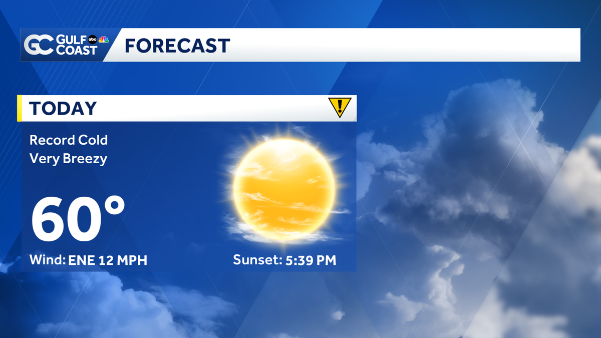
Bundle up and grab the extra hot cup of coffee Tuesday. Punta Gorda and Naples set record lows as temperatures plummeted into the upper 30s to low 40s. This is the coldest start since January for the Gulf Coast! With breezy conditions factored in, the wind chill values are in the upper 20s to low 30s out the door. Due to the record cold, Tuesday is a Gulf Coast Weather Impact Day. Expect record cold afternoon highs as well as many communities struggle to even reach the mid-60s. We’ll stay dry with plenty of sunshine but windy conditions stick around all day. Wind gusts will reach 20 to 25 mph, making it feel even colder. We’re in store for another chilly night with lows crashing into the mid-40s again. Gradual warming will slowly begin Wednesday, but below-normal temperatures are expected until the weekend. Conditions will stay dry through the rest of the week. The Atlantic hurricane season runs from June 1 through Nov. 30. Follow Gulf Coast News online and on air for Southwest Florida’s Most Accurate weather forecast.Be prepared with the Gulf Coast News 2025 Hurricane GuideLive Interactive RadarCheck out the interactive Gulf Coast Live RadarWatch your Gulf Coast Weather forecasts on TV or onlineHere’s where to find our latest weather forecast videoYou can also watch newscasts live or on demand hereOr download the Gulf Coast News app to stream on your phone or tabletFollow the Gulf Coast Storm Team on social mediaChief Meteorologist Allyson Rae on Facebook and XMeteorologist Sara Blue on Facebook and XMeteorologist Caroline Castora on Facebook and XMeteorologist Jim Dickey on Facebook and XMeteorologist Jason Dunning on Facebook and XMeteorologist Rob Duns on Facebook and XMeteorologist Lauren Hope on Facebook and XMeteorologist Raphael Tavernier on Facebook and XDOWNLOAD the free Gulf Coast News app for your latest breaking news and weather alerts. And check out the Very Local Gulf Coast app to stream news, entertainment and original programming on your TV.
FORT MYERS, Fla. —
Bundle up and grab the extra hot cup of coffee Tuesday. Punta Gorda and Naples set record lows as temperatures plummeted into the upper 30s to low 40s. This is the coldest start since January for the Gulf Coast! With breezy conditions factored in, the wind chill values are in the upper 20s to low 30s out the door. Due to the record cold, Tuesday is a Gulf Coast Weather Impact Day.

Gulf Coast News
Wind Chill Values Tuesday Morning
Expect record cold afternoon highs as well as many communities struggle to even reach the mid-60s. We’ll stay dry with plenty of sunshine but windy conditions stick around all day. Wind gusts will reach 20 to 25 mph, making it feel even colder. We’re in store for another chilly night with lows crashing into the mid-40s again.
Gradual warming will slowly begin Wednesday, but below-normal temperatures are expected until the weekend. Conditions will stay dry through the rest of the week.
The Atlantic hurricane season runs from June 1 through Nov. 30. Follow Gulf Coast News online and on air for Southwest Florida’s Most Accurate weather forecast.
Live Interactive Radar
Watch your Gulf Coast Weather forecasts on TV or online
Follow the Gulf Coast Storm Team on social media
DOWNLOAD the free Gulf Coast News app for your latest breaking news and weather alerts. And check out the Very Local Gulf Coast app to stream news, entertainment and original programming on your TV.