
ORLANDO, Fla. – Fog should start to lift mid-AM as we start to mix up the low levels of the atmosphere, but be careful early on. By the afternoon, we’re seeing plenty of sunshine as this ridge of high pressure holds. A WSW breeze drives our warm temps to kick off the weekend.
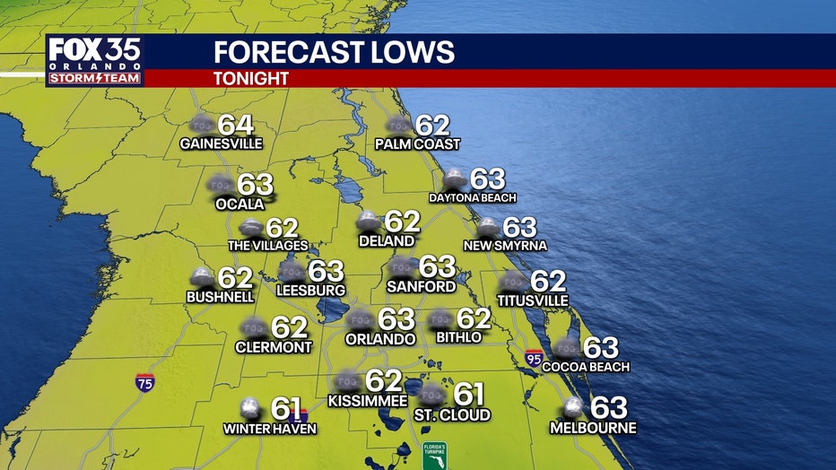
What will the weather look like tonight?
What to Expect:
Highs look to be in the lower to middle 80s, which is once again above normal for this time of November. Our average is now in the upper 70s (77°) The potential for a bit of fog is on the table Saturday night as well, thanks to the calm wind and mainly clear sky.
What will the weather look like tomorrow?
What to Expect:
Patchy dense fog is on the table early in the AM…if you’re traveling, be sure to drive carefully. A cold front approaches the area through the AM into the afternoon, but it doesn’t move through with any fanfare. A stray sprinkle is possible, but most will stay dry. The other noticeable change from Saturday to Sunday will be a bit more cloud cover overhead.
Looking ahead
What to Expect:
We don’t really tap into a cooler airmass behind the boundary, but temps may drop just a degree or two into Monday as the wind turns back around from the NNE. A spotty sprinkle is possible on Monday as this front pushes southward, but chances are slim.
Another area of high pressure quickly builds into the middle of our Thanksgiving week, leading to more sunshine and warmth. High temps for our Tuesday and Thanksgiving Eve look to top out in the lower to middle 80s.
Our attention then turns to a cold front Thanksgiving Day. This could bring a couple of showers, but chances aren’t looking impressive at the moment.
Chillier air does look to sink in just in time for Black Friday shopping, with highs during the afternoon in the 60s to 70s. Lows will be cooler too, so be sure to grab a jacket. Overnight readings could be back into the 40s-50s into Saturday AM.
The Source: This story was written based off information shared by the FOX 35 Storm Team on Nov. 22, 2025.