
Central Florida – the first real taste of fall arrives this week! A weak cold front moves through tonight (Sunday) with a few light showers, followed by a stronger front that finally drops us into the 70s by Friday.
Today’s Forecast
Isolated to scattered showers develop after 6–7 p.m.
Peak rain chance: 9 p.m. to midnight
Rainfall totals: Under ¼ inch for almost everyone
No thunderstorms or heavy rain expected
 Monday – Still Warm, Mostly Dry
Lingering clouds early, then partly sunny. Highs low to mid 80s.
Tuesday & Wednesday – Second, Stronger Cold Front Approaches
Small rain chance returns Wednesday afternoon/evening
Front passes Wednesday night into early Thursday
Temperatures start dropping Thursday afternoon
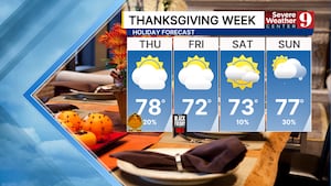
Thursday – Noticeable Cool-Down Begins
Highs only in the upper 70s (5–8° below average)
Friday – The Coolest Day of the Week
Highs in the low 70s across Central Florida
Morning lows in the upper 50s (mid 50s possible north of I-4)
Sunny, breezy, and dry — perfect fall weather
Weekend Outlook (Saturday & Sunday)
Cool & dry pattern locks in.
Morning lows in the mid to upper 50s (some spots low 50s)
Afternoon highs mid 70s — one of the coolest weekends in months