

Fort Myers Beach officials refined the town’s long-term comprehensive plan for what is likely the final time before it heads to state review. The Town Council and Local Planning Agency hosted a joint meeting Nov. 26 to finalize revisions to the 2045 Comprehensive Plan.
The town has spent the past year shaping the document, which outlines a long-term vision for future development while balancing Fort Myers Beach’s small-town character, quality of life and seasonal tourism economy as the community continues to rebuild from Hurricane Ian.
Council members are scheduled to vote on the plan’s final draft Dec. 1 at 9 a.m. The plan was first adopted in 1999 and must be updated every seven years under state law. Its policies guide development through the future land-use map and address community design, transportation, housing, historic preservation, utilities, conservation, coastal management and recreation.
Public outreach over the past year highlighted residents’ top concerns, including traffic congestion, access to health care and safeguarding the island’s small-town identity. Policies on maintaining beach access, limiting building height and density, promoting alternative transportation and preserving cultural assets were incorporated into the text.
The draft plan’s future land-use map outlines where development types may occur across the island. A draft section states that the map “protects and enhances the remaining natural and historic resources, preserves the small-town character of Fort Myers Beach, and protects residential neighborhoods against commercial intrusions.”

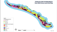
The Town of Fort Myers Beach 2045 Future Land Use Map outlines proposed mixed-use districts and long-term development patterns across the island. The updated map is part of the town’s revised comprehensive plan heading to state review.
Fort Myers government
The 2045 land-use map identifies five mixed-use districts along Estero Boulevard allowing commercial and multifamily residential development. The largest is the Times Square district at the island’s north end — its primary tourist destination — bounded by First Street, Estero Boulevard, Old San Carlos Boulevard and Pearl Street. The draft reviewed Nov. 25 encourages “compact urban design that enhances the pedestrian experience and limits the use of vehicles.”
A mid-island Civic Center district, from Chapel Street to Lover’s Lane, is intended to include housing and retail without encroaching on adjacent low-density neighborhoods. Permitted uses could include professional offices, restaurants and workforce housing.
A Center Island district, extending from Estero Bay to the Gulf and from Bayview Avenue to Madera Road, would support a lifestyle retail center, maintain an existing marina and provide opportunities for commercial development. A Theatre and Arts district would include properties west of Estero Boulevard from Mound Road to Ibis Street.
The southernmost mixed-use area, the Santini Village district, would run along Estero from Island Pines Way to Bella Lago Drive. Under the draft plan, it would be “the tallest and most dense district on the island,” supporting tourist and commercial development.
The plan’s opening statement describes Fort Myers Beach as a welcoming, multigenerational community. It concludes: “This is our slice of paradise. We share it in balanced ways that contribute positively toward our overall quality of life, with considerations of economic and social resiliency.”