
Foggy Thanksgiving morning as cold front approaches in Central Florida
YEAH. DID NOT FEEL GOOD AT ALL. OKAY, WELL, YOU MAY FEEL GOOD BECAUSE THE TEMPERATURES ARE GOING TO BE CHANGING HERE SOON. RIGHT, RIGHT. YOU NEED THOSE SWEATSHIRTS PRETTY SOON. SO COMFY CONDITIONS AS WE GET INTO TONIGHT. BUT THIS MORNING, THOUGH, WE ARE DEALING WITH SOME FOG, ESPECIALLY FOR AREAS NORTH AND WEST OF ORLANDO. LOOK AT THIS LAKE COUNTY IN EUSTIS. YOU’RE SEEING ABOUT A HALF MILE VISIBILITY RIGHT NOW. LEESBURG. THAT FOG IS VERY DENSE. AND WE’RE ALSO STARTING TO SEE THAT PATCHY, DENSE FOG IN SORRENTO AS WELL AS ASTATULA MASCOT AS WELL. SO HOPEFULLY YOU DON’T HAVE ANYWHERE TO BE ON THIS THANKSGIVING MORNING BECAUSE WE ARE DEALING WITH SOME FOG. YOU CAN SEE THAT FOG ACTUALLY FROM OUR LIVE LOOK FROM OUR TOWER CAMERA THERE OVER IN LAKE EOLA. IT IS VERY SOCKED IN RIGHT NOW IN DOWNTOWN ORLANDO. NOT ONLY ARE WE DEALING WITH FOG, LOTS OF CLOUDS AROUND AND TEMPERATURES THIS MORNING. VERY MILD. 67 IN DELAND, 67 IN TITUSVILLE. STARTING OFF THE MORNING AT 68 IN MELBOURNE, TEMPERATURES WILL PRETTY MUCH HOLD STEADY THROUGHOUT THE DAY. TODAY YOU NOTICE THE HIGH TEMPERATURES TODAY WILL ONLY REALLY BE IN THE LOW 70, SO ONLY A FEW DEGREES WARMER THAN WHERE WE ARE RIGHT NOW. AND THAT’S ALL THANKS TO A COLD FRONT THAT’S ACTUALLY GOING TO BE MOVING THROUGH THIS MORNING. YOU CAN SEE BY LATE MORNING WE’RE LOOKING AT LOTS OF CLOUDS AROUND. CAN’T RULE OUT A SPOT SHOWER AS THIS FRONT MOVES THROUGH. YOU CAN SEE BY 2:00 THIS AFTERNOON. CAN’T RULE OUT A SPOTTY SHOWER THERE IN BREVARD AND OSCEOLA COUNTIES. OTHERWISE, A LOT OF LOCATIONS WILL STAY DRY TODAY. AND THEN THE BIG TEMPERATURE DROP OFF WILL HAPPEN OVERNIGHT TONIGHT. RIGHT NOW, FIRST WARNING RADAR YOU CAN SEE NOT REALLY TRACKING ANY RAIN. WE DO HAVE THIS ONE TINY SHOWER THAT COULD MAKE ITS WAY INTO FAR SUMTER COUNTY. OTHERWISE, THE CHANCES OF RAIN ARE PRETTY LOW TODAY. ONLY HAVE A 10 TO 20% CHANCE OF RAIN IN LOTS OF CLOUDS AROUND, ESPECIALLY FOR THE FIRST HALF OF THE DAY. CLOUDS WILL GRADUALLY DIMINISH AS WE GO INTO LATE THIS EVENING, AND BOY ARE WE GOING TO SEE THOSE TEMPERATURES FALL OFF VERY QUICKLY. BY BLACK FRIDAY MORNING. LOWS WILL ONLY BE IN THE 40S TO UPPER 30S THERE IN OCALA. FEEL-LIKE TEMPERATURES, THOUGH, WILL BE IN THE 30S ACROSS THE BOARD. SO AS YOU WAKE UP ON BLACK FRIDAY MORNING, IT WILL BE COLD AND IN THE AFTERNOON IT WILL ALSO BE COLD AS WELL. HIGH TEMPERATURES WILL ONLY CLIMB INTO THE LOW 60S COME TOMORROW AFTERNOON. WEEKEND PLANNER WE ARE LOOKING AT SATURDAY A NICE START. IT WILL BE COLD THOUGH AND THEN CLOUDY. LOTS OF SUNSHINE IN THE AFTERNOON FOR SATURDAY. SUNDAY THOUGH WE’RE WATCHING CLOUDS THICKENING UP AND ALSO SOME RAIN SHOWERS MOVING IN OFF AHEAD OF THIS AREA OF LOW PRESSURE THAT’S GOING TO BE DEVELOPING FROM THE GULF HERE. AND THEN THAT’S GOING TO LIFT NORTH, BRING US RAIN SHOWERS AND EVEN A COUPLE THUNDERSTORMS AS WE HEAD INTO MONDAY INTO TUESDAY OF NEXT WEEK. SO RAIN, WHICH IS ACTUALLY MUCH NEEDED HERE IN CENTRAL FLORIDA, WILL BE RETURNING TO OUR FORECAST FOR NEXT WEEK. RIGHT NOW, THOUGH, AS WE TAKE A LOOK AT YOUR CENTRAL FLORIDA CERTIFIED MOST ACCURATE SEVEN-DAY FORECAST, WE ARE LOOKING AT HIGHS ONLY IN THE LOW 70S THIS AFTERNOON. TEMPERATURES QUICKLY REBOUND THIS WEEKEND THOUGH. AND LOOK AT THAT BY NEXT WEEK. WE DO HAVE SOME SHOWERS A
Foggy Thanksgiving morning as cold front approaches in Central Florida

Updated: 5:59 AM EST Nov 27, 2025
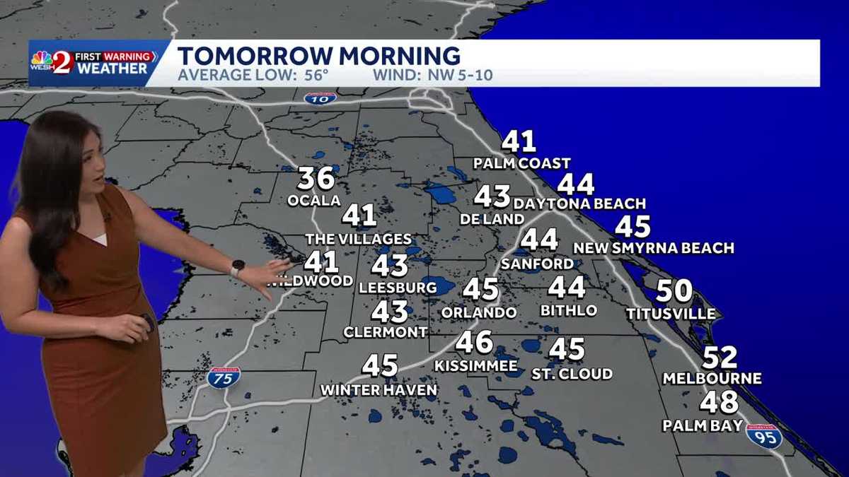
A foggy start to the morning in Orlando is giving way to a strong cold front moving through the area today, bringing a spot shower and plenty of clouds. Although no dense fog advisory has been issued, patchy dense fog is mostly affecting areas west of Orlando. Behind the cold front, temperatures this afternoon are expected to reach only the upper 60s to low 70s. Tomorrow will start chilly with lows in the 30s and 40s, and wind chills in the 30s across the board. Saturday morning will also be cold, though not as chilly as Friday morning. An area of low pressure is expected to bring rain next week on Monday night and Tuesday.First Warning Weather Stay with WESH 2 online and on-air for the most accurate Central Florida weather forecast.RadarSevere Weather AlertsDownload the WESH 2 News app to get the most up-to-date weather alerts. The First Warning Weather team includes First Warning Chief Meteorologist Tony Mainolfi, Eric Burris, Marquise Meda and Cam Tran.
ORLANDO, Fla. —
A foggy start to the morning in Orlando is giving way to a strong cold front moving through the area today, bringing a spot shower and plenty of clouds.
Although no dense fog advisory has been issued, patchy dense fog is mostly affecting areas west of Orlando.
Behind the cold front, temperatures this afternoon are expected to reach only the upper 60s to low 70s.
Tomorrow will start chilly with lows in the 30s and 40s, and wind chills in the 30s across the board.
Saturday morning will also be cold, though not as chilly as Friday morning.
An area of low pressure is expected to bring rain next week on Monday night and Tuesday.
First Warning Weather
Stay with WESH 2 online and on-air for the most accurate Central Florida weather forecast.
Download the WESH 2 News app to get the most up-to-date weather alerts.
The First Warning Weather team includes First Warning Chief Meteorologist Tony Mainolfi, Eric Burris, Marquise Meda and Cam Tran.