
Cold weather hits Central Florida on Black Friday
PARADE. GUESS WHAT. WELL, THEY BROUGHT IT. HERE. IT IS A VERY CHILLY START TO YOUR BLACK FRIDAY MORNING LIVE. LOOK OUTSIDE. VERY FESTIVE THOUGH, AS WE TAKE A LOOK AT DOWNTOWN OCALA. ALL THE LIGHTS ARE UP THERE AT THE SQUARE. WE’RE CURRENTLY AT 38 DEGREES IN OCALA, 43 RIGHT NOW IN PALM COAST, AND A VERY COLD 46 IN THE VILLAGES. THESE ARE THE ACTUAL AIR TEMPERATURES, AND THEY DON’T REALLY EVEN TELL THE FULL STORY BECAUSE WINDS ARE RATHER GUSTY OUT OF THE NORTH NORTHWEST AT 10 TO 20MPH. SO IT ACTUALLY MAKES IT FEEL ABOUT FIVE DEGREES COLDER THAN THOSE AIR TEMPERATURES INDICATE. YOU CAN SEE RIGHT NOW VERY GUSTY WIND IN LEESBURG AT 12MPH. 15 IN ORLANDO. IT IS BREEZY RIGHT NOW IN SANFORD. AND THAT IS ADDING THAT EXTRA BITE IN THE AIR. WE’LL SEE PLENTY OF SUNSHINE TODAY AND DRY CONDITIONS, BUT DON’T LET THAT SUNSHINE FOOL YOU. IT’S STILL GOING TO BE COLD THIS AFTERNOON. WE’RE ONLY GOING TO SEE A HIGH OF 60 IN PALM COAST LATER TODAY, 62 IN DELAND AND 64 IN KISSIMMEE. NO RAIN TO CONTEND WITH AS HIGH PRESSURE IS IN CONTROL. SO OUR FIRST WARNING RADAR NOT PICKING UP A SINGLE DROP OF RAIN. AND AS WE BREAK DOWN YOUR 12 HOUR FORECAST, IT’S GOING TO BE A NICE ONE TO GET OUTSIDE. EVEN THOUGH WE ARE GOING TO SEE COLD CONDITIONS. 64 THE HIGH LATER ON TODAY. ONCE THE SUN SETS, THOUGH, TEMPERATURES WILL PLUMMET VERY QUICKLY IN THE OVERNIGHT HOURS. AND WE’RE LOOKING AT ANOTHER COLD START FOR TOMORROW MORNING, BUT NOT AS CHILLY AS WHERE WE ARE RIGHT NOW. OCALA WILL DROP DOWN TO AROUND 41 ON SATURDAY MORNING, 46 IN LEESBURG, 50 IN ORLANDO TOMORROW MORNING. IF YOU’RE NOT A BIG FAN OF THESE CHILLY TEMPERATURES THAT WE’RE SEEING RIGHT NOW, DON’T WORRY, THE TEMPERATURES WILL REBOUND THIS UPCOMING WEEKEND. YOU CAN SEE BY SATURDAY AFTERNOON WE’RE ALREADY BACK INTO THE LOW 70S FOR HIGHS. AND THEN ON SUNDAY, EVEN WARMER WITH A HIGH OF 80 DEGREES. NOW ON SUNDAY, WE DO HAVE A 20% CHANCE OF RAIN. SO OUT OF THE TWO WEEKEND DAYS, SATURDAY WILL BE THE NICER OF THE TWO. AND THEN WE ARE TRACKING SOME RAIN FOR NEXT WEEK, AS AN AREA OF LOW PRESSURE DEVELOPS ALONG THIS FRONTAL BOUNDARY. THIS IS GOING TO BE COMING IN FROM THE GULF, AND THIS IS GOING TO BRING US SOME FAIRLY WIDESPREAD RAIN BY TUESDAY OF NEXT WEEK. SO THAT’S WHEN WE’LL DEFINITELY NEED THAT RAIN GEAR. THANKFULLY THOUGH, THIS IS A VERY FAST MOVING FRONT AND BEHIND THIS AREA OF LOW PRESSURE AND IT’S ATTACHED FRONT. WE ARE GOING TO SEE DRIER AND COOLER AIR FOR MIDWEEK NEXT WEEK. SO TAKING A LOOK AT YOUR CENTRAL FLORIDA CERTIFIED MOST ACCURATE SEVEN DAY FORECAST, A VERY NICE WEATHER FOR THIS AFTERNOON, ALTHOUGH STILL RATHER COLD THOUGH BREEZY CONDITIONS CONTINUE FOR SATURDAY AND SUNDAY, BUT IT WILL BE WARM THOUGH HIGH OF 80 DEGREES ON SUNDAY. MILD CONDITIONS FOR EARLY NEXT WEEK UP AHEAD OF THAT AREA. LOW PRESSURE BEHIND THAT LOW. WE ARE GOING TO SEE VERY COMFORTABLE WEATHER BY MIDWEEK NEXT WEEK. THAT’S A LOOK AT YOUR SEVEN DAY FOR INLAND SPOTS. HERE’S A LOOK AT YOUR SEVEN DAY FOR FOLKS ALONG THE COAST. NOW THE WINDS WILL START TO BE MORE ONSHORE BY TOMORROW SO WE COULD SEE A COUPLE RAIN SHOWERS ALONG OUR COASTAL COMMUNITIES SATURDAY AFTERNOON. THAT WILL BE THE CASE ON SUNDAY AS WELL. AND THEN ALL OF US WILL GET THAT UPTICK I
Orlando is experiencing a cold start to Black Friday, with temperatures dropping to the 30s and 40s. In Orlando, some stubborn overnight clouds have held on, keeping temperatures in the 50s, but they are expected to eventually drop to the upper 40s before daybreak. A cold, sunny day is forecast, with highs only in the low 60s. This blast of cold air will be short-lived, as temperatures are expected to warm back up this weekend. Rain is expected to return to the forecast next week, on Monday and Tuesday, with the next front.First Warning Weather Stay with WESH 2 online and on-air for the most accurate Central Florida weather forecast.RadarSevere Weather AlertsDownload the WESH 2 News app to get the most up-to-date weather alerts. The First Warning Weather team includes First Warning Chief Meteorologist Tony Mainolfi, Eric Burris, Marquise Meda and Cam Tran.
ORLANDO, Fla. —
Orlando is experiencing a cold start to Black Friday, with temperatures dropping to the 30s and 40s.
In Orlando, some stubborn overnight clouds have held on, keeping temperatures in the 50s, but they are expected to eventually drop to the upper 40s before daybreak.
A cold, sunny day is forecast, with highs only in the low 60s.
This blast of cold air will be short-lived, as temperatures are expected to warm back up this weekend.
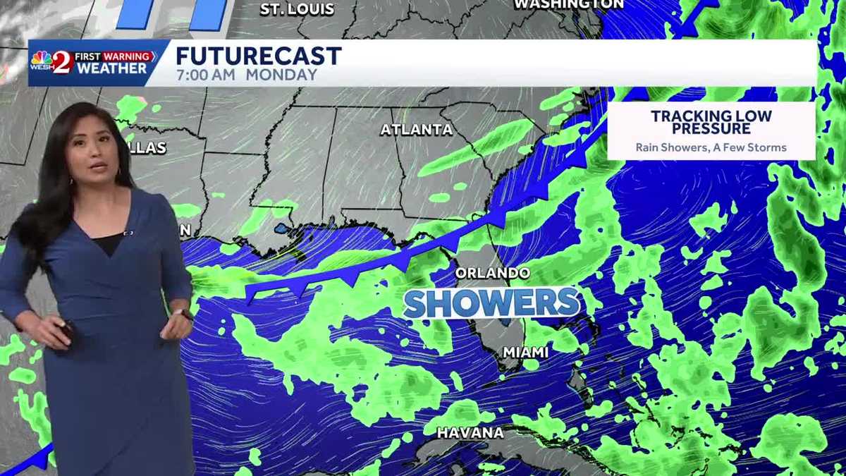
Rain is expected to return to the forecast next week, on Monday and Tuesday, with the next front.
First Warning Weather
Stay with WESH 2 online and on-air for the most accurate Central Florida weather forecast.
Download the WESH 2 News app to get the most up-to-date weather alerts.
The First Warning Weather team includes First Warning Chief Meteorologist Tony Mainolfi, Eric Burris, Marquise Meda and Cam Tran.