
TALLAHASSEE, Fla. (WCTV) – After a chilly morning, it will be cool and breezy this afternoon. Winds are expected to increase the fire risk in North Florida and South Georgia.
A cool Black Friday:
Mostly sunny and breezy this afternoon. Highs will reach the upper 50s. Winds out of the north between 10 and 20 mph, with gusts to 25 mph. The winds will make it feel like the low 50s during the afternoon.
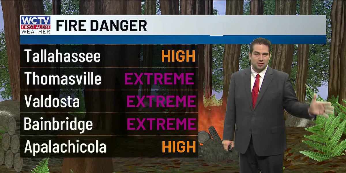
The wind gusts combined with very low humidity increase the fire risk today. The fire risk is high for North Florida and extreme for South Georgia. Avoid burning and check here or with local officials if your city, town or county is under a burn ban because of the dry grass and elevated fire danger.
Clouds develop this evening and overnight, so I do not expect to be quite as cold tomorrow morning. Still chilly though, in the mid-30s.
Quiet weekend:
Saturday afternoon is looking partly cloudy. Highs a little warmer in the mid 60s.
Sunday will feature a mix of sun and clouds with a chance of some afternoon showers. This will not be a washout or drought-busting, but there certainly will be a few good downpours. Highs in the low 70s.
Rain early next week:
The next weathermaker arrives late Monday and into your Tuesday. There is solid agreement between models organizing this rainmaker.
It looks like the heaviest of the rain will fall just to our north, but we still should get a solid rain, at least 0.5″ in many spots. I will track any changes in the coming days. Either way, this is looking like our best and most widespread rain chance we have seen in quite some time.
Drier and cooler after the front passes mid to late next week.
To stay updated on all the latest forecasts and weather, follow WCTV First Alert Weather on Facebook and X (Twitter).
Click here to see all the latest weather headlines and here to view the First Alert Radar. Receive push alerts and watch the latest forecast anytime on the free WCTV First Alert Weather app. Click here to download it now.
Interested in becoming a WCTV First Alert Weather Watcher? Click here to join the team!
Copyright 2025 WCTV. All rights reserved.