
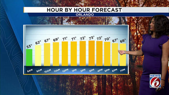
ORLANDO, Fla. – If you’re stepping out around Central Florida this weekend, expect some big changes from yesterday’s chill. Temperatures are rebounding into the upper 60s and lower 70s on Saturday with a much milder feel. Still, those strong winds won’t be going anywhere just yet. Gusts up to 30 mph are possible along the coast and up to 20 mph across inland locations.
Highs
Expect a mix of sunshine and clouds, but dry weather holds both Saturday and Sunday. By Sunday, highs are expected to climb back to 81 degrees, bringing even more warmth and abundant sun.
The quiet stretch won’t last all week. Looking ahead, models are still hinting at a storm system heading toward Central Florida late Monday into Tuesday. This system is expected to increase rain chances to about 40 percent on Tuesday, with the possibility of some embedded thunderstorms. The forecast shows that rain and thunderstorms may linger into Wednesday morning, so anyone with outdoor plans mid-week might want to keep an umbrella handy.
The upcoming front connected to this system is expected to drop afternoon temperatures back into the mid-70s Wednesday and Thursday. While the details are still developing and rain chances may increase as Tuesday nears, it’s a good idea to keep an eye on updated forecasts from the Pinpoint Weather team.
Tropics remain quiet as hurricane season wraps up
There’s no need to worry about the tropics. No tropical activity is expected in the next several days, and there’s just one day left until the official end of hurricane season. That’s great news for Central Florida, giving everyone a nice break from tropical concerns.
The Pinpoint Weather 7-day forecast shows mostly mild and dry conditions after the midweek showers clear out, with temperatures stabilizing in the lower 80s early in the week before cooling slightly.
Want to share your weather photos or videos? PinIt! at ClickOrlando.com/pins.
Copyright 2025 by WKMG ClickOrlando – All rights reserved.