
ORLANDO, Fla. – Today was overall a spectacular Saturday for the majority of us here in Central Florida. The sun had its periods of breaking through the mixed clouds we saw throughout the morning and afternoon hours. Winds were somewhat gusty but tame compared to what we saw yesterday combined with the colder temperatures across the area.
It just made you want to go outside and do stuff, yeah?
Since high pressure migrated off the east coast, temperatures have come up quite a bit in just the span of 24 hours (Copyright WKMG 2025)
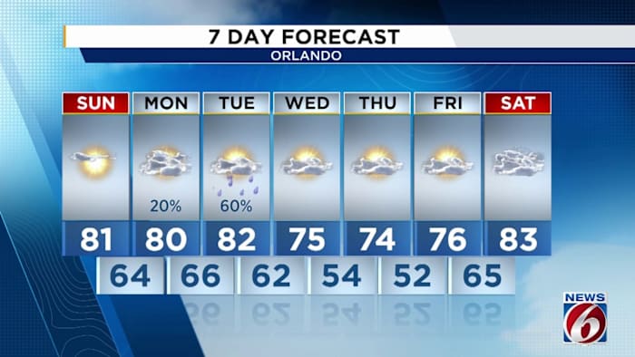
I hope you enjoyed the day today, because tomorrow we’re going to continue looking a lot more like Florida out there as our afternoon high’s reach back into the low 80s across parts of town.
There will still be some periods of mixed clouds and sunshine thanks to the easterly winds we’ve had set up coming in off the Atlantic coast. They’ll still be fairly sporty as well, anywhere between 15-25 mph right on the immediate shores of Flagler, Volusia, and Brevard counties.
High rip current risks are in effect for our east coast counties, all thanks to the easterly wind gusts we’re seeing (Copyright WKMG 2025)
Because of this, we’re tracking a HIGH rip current risk for those same aforementioned counties with 3-5 foot waves possible all thanks to the cranking onshore floor we’re experiencing. So please be careful if you do decide to take advantage of this warm up and hit the coast.
Interior Central Florida will still be breezy as well despite being further away from the coast.
For your week ahead, it’s going to get a bit bumpy. I’m looking at the possibility we’ll be up and down in a variety of ways, from rain chances, above average temps, right back into chillier mornings, then back again.
Many of us will reach back into the 80 degree mark for your Sunday with a continuation into Monday and Tuesday before temps fall off again (Copyright WKMG 2025)
As we get into Monday night, overall moisture in our local atmosphere will start to increase as we await the arrival of a storm system prepping to get underway somewhere between the Texas coast and east Texas/Louisiana.
Tomorrow’s high temps reach right back into above average territory with the return of 80 degrees in a few spots (Copyright WKMG 2025)
Once it does form, it’ll pick up some good forward speed and race towards the east and north east, driving another plunge of cooler, drier air from up north in back behind it. Along the leading edge it’s expected to yank up additional tropical moisture from our area and further south.
Rain chances are forecast to balloon upwards Tuesday, with a potential extension of this into the early morning hours of Wednesday.
For the time being, it looks to be just that – a shot at some much-needed rainfall for a good portion of us. There is a slight chance some isolated thunderstorms try to organize during the warmest portions of the day, pending the arrival of our cold front as the low swoops by to our north.
This is the first of a few possible storm systems headed our way as we get into early December (Copyright WKMG 2025)
Otherwise, I’m just not seeing any risk for strong to severe storms. It doesn’t appear we’ll get too gusty inside your more well-developed rains and storms as they work through Central Florida. This bears monitoring of course, as models will likely continue to adjust as we get closer to game time.
Then through Wednesday and Thursday we’re back to average if not below average temperatures with lows in the 50s and afternoon highs grasping at 70s.
Looking down the ways into the first half of December, it does seem more likely we’ll start to get more consistent bouts of rain towards Florida. The pattern that looks to manifest could drive more of these lower latitude low pressure systems along the upper Gulf coast, dragging with them better chances for rain.
This is good news, especially if we’re still to expect a somewhat benign and dry winter season ahead!
Daily Forecast
The News 6 Weather team ensures you’re always on top of the day’s weather.
Copyright 2025 by WKMG ClickOrlando – All rights reserved.