
Rain and storms on the way
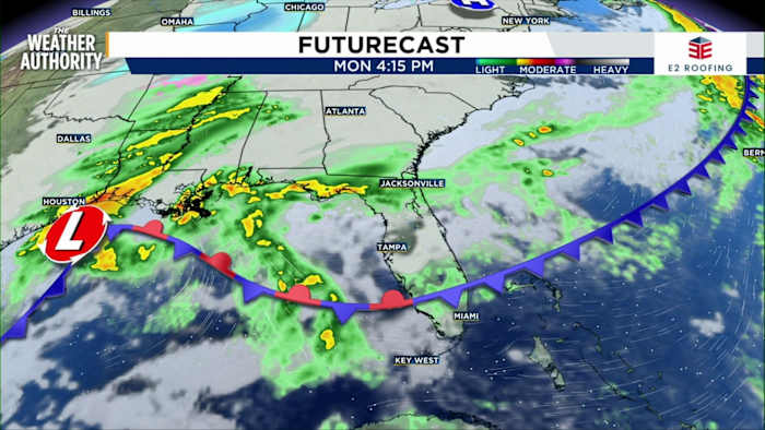
JACKSONVILLE, Fla. – I’ve been tracking the clouds this morning, and you may have already noticed those building up across Jacksonville and Northeast Florida. According to my Exact Track 4D radar, we’re looking at rain moving in later today. If you have outdoor plans, you’ll want to keep an umbrella handy—showers could start popping up as early as this afternoon, but even stronger rain looks likely heading into tonight and especially Tuesday.
Here’s what’s expected: rain chances are at 30 percent today, but that jumps to 70 percent tomorrow. Most of us should plan for a quarter-inch to an inch of rain, with 2 to 3 inches possible mainly for Southeast Georgia and the Suwannee River Valley. We did catch some showers earlier in Brunswick and Kingsland, though those fizzled out this morning. Humidity is up, and that’s only going to feed the chance for more rain as we move forward.
Looking past midweek, another system is expected to bring additional showers as we move into Friday and through the upcoming weekend.
Severe risks and main hazards
Let’s talk about what kind of storms we’re expecting. The main risk for severe weather arrives Tuesday. Right now, the strongest storms are forecast west of Jacksonville, in areas like Live Oak and Lake City. For most of Northeast Florida and Southeast Georgia, the risk is for non-severe but still strong storms.
The biggest thing to watch out for? Gusty winds and brief heavy downpours. The tornado risk is very low, but I want everyone to know: if warm air really lifts and instability increases, a brief tornado is possible. For most of us though, the wind and soaking rain are the primary concerns.
As always, you can get real-time alerts from The Weather Authority by downloading our app. Keeping up with those notifications is the easiest way to stay prepared as storms move in.
Temperatures and extended forecast
Temperatures are starting out in the mid-60s at most locations this morning, with highs expected to top out around the low to mid-70s today and Tuesday. After that rain and storms roll through, look for a temporary cool-down—Wednesday and Thursday will likely bring highs in the 60s, and overnight lows could dip into the 40s, which is below our seasonal averages.
Humidity will also take a dive after midweek, so things should feel less muggy Wednesday into Thursday. As we look toward the weekend, temperatures are expected to rebound back into the 70s, but that next batch of showers will keep things interesting for anyone making outdoor plans.
One quick safety reminder: with the onshore winds picking up, rip current risk is high. The water might be a bit too chilly for swimming anyway, but if you’re heading to area beaches, be cautious.
Have a great week—and if you catch some stormy skies or rainbow moments, share your pictures with us on SnapJAX at https://www.news4jax.com/snapjax/. I’ll be keeping watch and bringing you the latest on News4JAX and The Weather Authority.
Copyright 2025 by WJXT News4JAX – All rights reserved.