
Next Big Cool Down: Central Florida Wind Chill Values Drop to the 30s Friday Morning
Next Big Cool Down: Central Florida Wind Chill Values Drop to the 30s Friday Morning
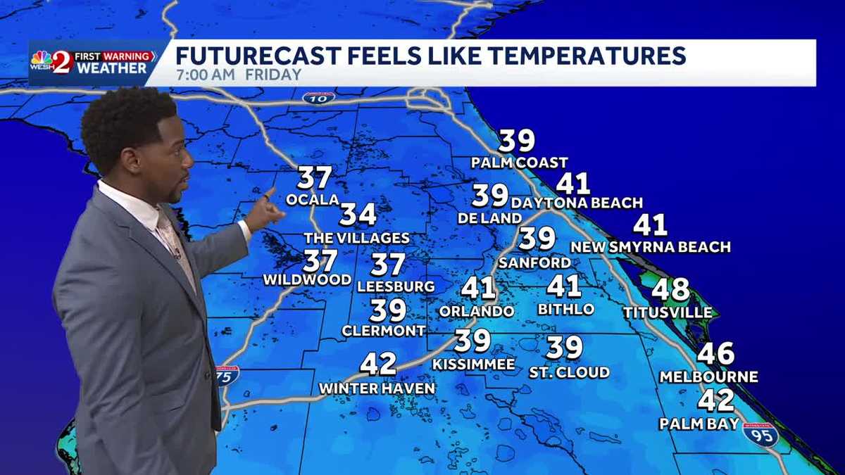
COURSE, THE BIG MATCHUPS. ALL RIGHT, TIME TO GET A CHECK OF OUR FORECAST WITH METEOROLOGIST MARQUISE MEDA. SO FRIDAY MORNING EARLY, I’M GOING TO BE OUT IN CELEBRATION FOR OUR BIG SHARE YOUR CHRISTMAS DAY. AND WE CERTAINLY HOPE YOU JOIN US. AND YOU KNOW, THEY HAVE THAT SNOW IN CELEBRATION. AND I THINK IT’S GOING TO FEEL LIKE IT’S REAL. WE’RE GETTING A BLAST OF COOLER AIR COMING OUR WAY, RIGHT. JACK FROST WILL BE DEFINITELY NIPPING AT YOUR NOSE COMING FRIDAY, SO I DO RECOMMEND BUNDLING UP. HERE’S A LOOK AT YOUR SEVEN DAY FORECAST ALONG THE COAST, DROPPING ALL THE WAY DOWN TO THE UPPER 40S TOMORROW MORNING. AND IF THAT’S NOT LOW ENOUGH, WE CAN TAKE IT A FEW EXTRA NOTCHES DOWN INTO THE MID 40S ON FRIDAY MORNING. SO DEFINITELY A VERY COOL START TO THE END OF THE WORKWEEK. THANKFULLY, OVER THE COURSE OF THE WEEKEND, WE’LL START TO DEFROST JUST A LITTLE BIT. SATURDAY AND SUNDAY HAVE TEMPERATURES BACK IN THE LOWER 70S, LOW AND MID 70S WITH PRETTY CONSISTENT SUNSHINE. MONDAY AND TUESDAY COME IN AND TAKE THAT SUNSHINE AWAY. WE’LL TRADE IT IN FOR RAIN SHOWERS AS WE DO SEE TEMPERATURES DROPPING ALL THE WAY DOWN INTO THE MID AND UPPER 60S. TO START OFF YOUR WORKWEEK. SO MY ADVICE FOR YOU NOW ENJOY THE SUNSHINE WHILE IT’S HERE. AND THESE SLIGHTLY WARMER TEMPERATURES AS WELL. 68 DEGREES OUT THE DOOR IN DAYTONA BEACH WHERE YOU’RE SPORTING PARTLY CLOUDY SKIES. LATER IN THE AFTERNOON, MORE SUNSHINE WILL RETURN. WE’RE SEEING HIGH PRESSURE ALLOW FOR SOME CLARITY IN OUR FORECAST BEFORE WE COOL DOWN OVERNIGHT. SO OUT ON VISIBLE SATELLITE, YOU SEE, THE FURTHER WEST YOU GO, THE MORE CLOUDS YOU’RE FACING OUTSIDE. RIGHT NOW WE HAVE CLOUDS LIFTING ACROSS THE I-4 CORRIDOR. A COUPLE CUMULUS CONDITIONS ACROSS I-95 HAVE TEMPERATURES IN THE LOWER 70S FOR TITUSVILLE, MELBOURNE AND PALM BAY. UPPER 60S. ONCE YOU STEP INTO VOLUSIA COUNTY, 68 ACROSS NEW SMYRNA BEACH AND DAYTONA. INSIDE THE CITY. BEAUTIFUL. YOU’RE IN THE MID 60S. AS I MENTIONED, CLOUDS WILL CLEAR AS YOU ENTER THE EVENING. SO PERFECTLY CLEAR CONDITIONS EARLY ON, A FEW PARTLY CLOUDY CONDITIONS START TO FILTER BACK INTO THE PICTURE EARLY ON THURSDAY MORNING, BUT ULTIMATELY YOU’RE STAYING DRY FOR THE NEXT 24 HOURS. IN FACT, YOU’RE STAYING DRY ALL THROUGHOUT THE REST OF YOUR WORK WEEK AND INTO THE WEEKEND. SO CLEAR SKIES ARE BACK TONIGHT UNDER THESE CLEAR CONDITIONS, RADIATIONAL COOLING WILL BE TAKING PLACE, DROPPING TEMPERATURES INTO THE MID 50S. TO START OFF YOUR THURSDAY MORNING IN ORLANDO, BUT COMING IN ON THURSDAY, IT’S A WEAK AND DRY COLD FRONT, ONLY GOING TO DECREASE YOUR TEMPERATURES AS WE GET READY FOR FRIDAY. COMING UP. SO COMFORTABLE OVERNIGHTS, BUT WE START TO GET MUCH COOLER ON FRIDAY AS WE MOVE ACROSS YOUR THURSDAY, THOUGH, TEMPERATURES SHOULD RANGE BETWEEN 68 AND 74 DEGREES UNDER. MOSTLY SUNSHINE ON FRIDAY. YOU HAVE TO WATCH OUT FOR ANY POTENTIAL FROST. WIND CHILL VALUES WILL BE DROPPING ALL THE WAY DOWN TO THE 30S, ESPECIALLY ACROSS OUR NORTH AND WESTERNMOST COUNTIES. LET’S GO AHEAD AND TAKE A LOOK AT THOSE NUMBERS. IT’S GOING TO FEEL LIKE 37 IN OCALA, FEELING LIKE 34 DEGREES IN THE VILLAGES. SO THAT’S WHY WE’RE RECOMMENDING THOSE EXTRA LAYERS AS WE START OFF THE WEEKEND, THOUGH, MUCH MORE COMFORTABLE WEATHER IS BACK IN THE PICTURE. BUT BEWARE COLD FRONT. IT’S GOING TO BE RIGHT AROUND THE CORNER, SO YOUR SEVEN DAY FORECAST SHAPES UP LIKE THIS MID 60S ON THURSDAY, MID 40S THURSDAY NIGHT INTO FRIDAY. DEFINITELY THE COOLEST OF YOUR WORKWEEK. THAT REMAINS WARMER THIS WEEKEND, BUT WATCH OUT FOR THE RAIN SHOWERS RETURNING ON MONDA
Next Big Cool Down: Central Florida Wind Chill Values Drop to the 30s Friday Morning
Next Big Cool Down: Central Florida Wind Chill Values Drop to the 30s Friday Morning

Updated: 1:33 PM EST Dec 10, 2025
Next Big Cool Down: Central Florida Wind Chill Values Drop to the 30s Friday MorningOur stretch of mild/cooler weather continues today, with temperatures that barely squeeze into the lower seventies today. Sunshine will be plentiful with a N/NW wind keeping us below seasonal tonight. Under clear skies expect to drop back into the lower fifties overnight. Even colder temps will be back tomorrow. Thursday will by far be the coolest day of the week, as your high for tomorrow will stall in the mid-sixties during the afternoon. Those cooler conditions will follow us into the overnight hours as well. Friday wakeup temperatures will drop into the mid-forties, so make sure to bundle up before stepping out.
Next Big Cool Down: Central Florida Wind Chill Values Drop to the 30s Friday Morning
Our stretch of mild/cooler weather continues today, with temperatures that barely squeeze into the lower seventies today. Sunshine will be plentiful with a N/NW wind keeping us below seasonal tonight. Under clear skies expect to drop back into the lower fifties overnight. Even colder temps will be back tomorrow. Thursday will by far be the coolest day of the week, as your high for tomorrow will stall in the mid-sixties during the afternoon. Those cooler conditions will follow us into the overnight hours as well. Friday wakeup temperatures will drop into the mid-forties, so make sure to bundle up before stepping out.