

Portions of northern Florida are facing a freeze watch Thursday night and into Friday morning as temperatures will dip below freezing, according to the National Weather Service (NWS).
A surge of Arctic air driven by a weakened polar vortex is pushing temperatures far below seasonal norms across the United States, reaching as far south as Florida. The event has prompted the NWS to issue freeze watches and previous frost advisories throughout the state.
Unusually cold weather poses risks to outdoor vegetation, infrastructure, and potentially pets, especially in regions unaccustomed to freezing conditions. This weather event affects thousands and comes amid broader concerns about extreme winter weather and its impacts in the Southeast.
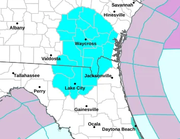
According to the NWS, the watch impacts portions of northeast and northern Florida, including Lake City, Jasper, White Springs and Hilliard. The warning also includes portions of southeast Georgia.
Below is a map of the impacted region:
“Appropriate action should be taken to ensure tender vegetation and outdoor pets have adequate protection from the cold temperatures. Young children, the elderly and the homeless are especially vulnerable to the cold. Take measures to protect them,” the NWS said in the freeze watch.
NWS Weather Prediction Center meteorologist Rich Otto told Newsweek on Wednesday that “a lot of the Eastern U.S. is below average. Some of the temperatures in Florida will be 10 to 20 degrees below average on Friday.”
“Northern and interior Florida are more at risk compared to coastal communities. There is potential for damage to crops,” Otto said.

NWS Jacksonville posted to X on Wednesday, “Another cold night is in store for Thursday night A Freeze Watch is in effect for inland SE GA & portions of inland NE FL late Thursday night into Friday morning. Low temperatures within the watch will be 30-32 degrees with areas to widespread frost formation possible.”
NWS Melbourne said on X on Wednesday, “Dec 10 | A morning sprinkle possible, otherwise decreasing cloudiness today with temps near normal in the low to mid 70s. A cold front pushes through early Thu and brings a quick shot of colder air, then a gradual warm-up back to seasonable levels by Sat.”
Florida residents are urged to continue monitoring local updates for any changes in weather conditions.