
Central Florida wakes to temps in 30s, 40s before afternoon warmup
THOUGH. THAT’S TOO COLD FOR US, RIGHT? YEAH, DEFINITELY VERY CHILLY OUTDOORS. SO BUNDLE UP BEFORE YOU STEP OUTSIDE. TEMPERATURES HAVE ALREADY FALLEN INTO THE 30S IN PLACES LIKE MARION AND FLAGLER COUNTY. HERE IN ORANGE COUNTY, ORLANDO IN PARTICULAR, YOU’RE SHOWING 48 DEGREES JUST PAST 518. NOW, AS WE CONTINUE ACROSS THE REST OF THE MORNING, WE MAY DROP AN EXTRA DEGREE BEFORE SUNRISE, BUT ULTIMATELY WE’RE COOLER IN ORLANDO THAN WE ARE IN PLACES LIKE LOS ANGELES. IN FACT, ACROSS THE WEST COAST, TEMPERATURES ARE TRENDING WARM OVERNIGHT. 57 IN LA LOOKS LIKE PORTLAND, 54 DEGREES WARMER THAN US HERE IN CENTRAL FLORIDA. 48 AS YOU STEP OUTSIDE IN ORLANDO CURRENTLY AND YOU’RE BACK IN THE MID AND UPPER 30S, ONCE YOU SKIP ON OVER TO I-75 IN OCALA, 36 DEGREES OUT THAT DIRECTION, PALM COAST 38. SO DEFINITELY COOLER THAN OUR SEASONAL AVERAGE TO START OFF THE DAY. THANKFULLY, WE’RE NOT SHOWING ANY COLD WEATHER ADVISORIES THIS FRIDAY MORNING, BUT WE COULD STILL SEE SOME PATCHY FROST. FROST ONCE YOU MOVE OUT TOWARDS I-75 THROUGH WILDWOOD, THE VILLAGES, AND OCALA. SO JUST MAKE SURE YOU’RE STARTING YOUR CARS AND DEFROSTING THEM A LITTLE BIT. EARLY THIS MORNING. ULTIMATELY, IF YOU’RE HEADING OUT TOWARDS DAYTONA INTERNATIONAL SPEEDWAY FOR SHARE YOUR CHRISTMAS THIS MORNING, THAT’S WHERE ERIC BURRIS IS GOING TO BE. I STILL RECOMMEND THOSE EXTRA LONG SLEEVES AND WINTER ATTIRE AS TEMPERATURES WILL BE TRENDING COOL THIS MORNING. YOU WON’T MAKE IT BACK INTO THE 70S IF YOU’RE IN DAYTONA LATER IN THE AFTERNOON. DESPITE ALL THE SUNSHINE IN THE WORLD, IT’S STILL GOING TO BE A LITTLE BIT COOL OUTDOORS. 69 FOR YOUR HIGH OUT THAT DIRECTION AS YOU MOVE FURTHER SOUTH ACROSS I-4. 72 FROM SANFORD THROUGH WINDSOR HAVEN. SO IT’S A TIGHT KNIT GROUPING OF TEMPERATURES TODAY. AND LATER ON TONIGHT LOOK TO FALL BACK INTO THE 40S AND THE 50S AS HIGH PRESSURE BEGINS TO SHIFT OUT TOWARDS THE EAST. WARMER WEATHER IS BACK TOMORROW. YEAH, WE’LL START OFF THE WEEKEND IN THE MID 70S ON SATURDAY. SMALL CHANCE FOR A COASTAL SHOWER ONCE WE MOVE ACROSS YOUR SUNDAY. BUT THE BIGGER CHANGE COMING YOUR WAY WILL BE THIS NEXT COLD FRONT DESCENDING TOWARDS THE SOUTH. FOR MOST OF US IT’S GOING TO BE A DRY, COLD FRONT. SO THIS WEEKEND, MORE SUNSHINE AND COMFORTABLE TEMPERATURES WILL BE IN PLACE FOR YOUR OCOEE TREE LIGHTING CEREMONY TAKING PLACE IN ORANGE COUNTY. MID 70S IN THE AFTERNOON. AND THEN ON MONDAY, HERE COMES A BLAST OF MORE COOL AIR, DROPPING US DOWN TO THE 60S. TO START OFF YOUR WORKWEEK. NICE AND DRY THOUGH, SO SUNSHINE WILL BE A FAMILIAR FRIEND COMING YOUR WAY OVER THE NEXT SEVEN DAYS. SMALL CHANCE FOR SOME SPRINKLES OF RAIN, ESPECIALLY ALONG THE COAST ON SUNDAY WITH HIGHS OF 78 DEGREES, BUT IT’S QUITE THE DROP OFF. BY MONDAY. YOU FALL BACK INTO THE MID 60S, MONDAY IN THE AFTERNOON, AND THEN WE’RE IN THE 70S STARTING
Central Florida wakes to temps in 30s, 40s before afternoon warmup

Updated: 6:08 AM EST Dec 12, 2025
Central Florida begins the day with cold temperatures and frost concerns, as temperatures in the northern and western counties have fallen into the thirties. It’s a clear start to the morning, so temperatures could still lose an extra degree or two before sunrise. Sunshine will be plentiful today with an onshore flow, allowing temperatures to warm into the low seventies inland later this afternoon. The warming trend will continue into the weekend, with peak temperatures reaching the mid and upper seventies on Saturday and Sunday. However, a dry cold front will sneak into the picture as the weekend concludes, dropping temperatures into the lower sixties to start off the workweek.First Warning Weather Stay with WESH 2 online and on-air for the most accurate Central Florida weather forecast.RadarSevere Weather AlertsDownload the WESH 2 News app to get the most up-to-date weather alerts. The First Warning Weather team includes First Warning Chief Meteorologist Tony Mainolfi, Eric Burris, Marquise Meda and Cam Tran.
ORLANDO, Fla. —
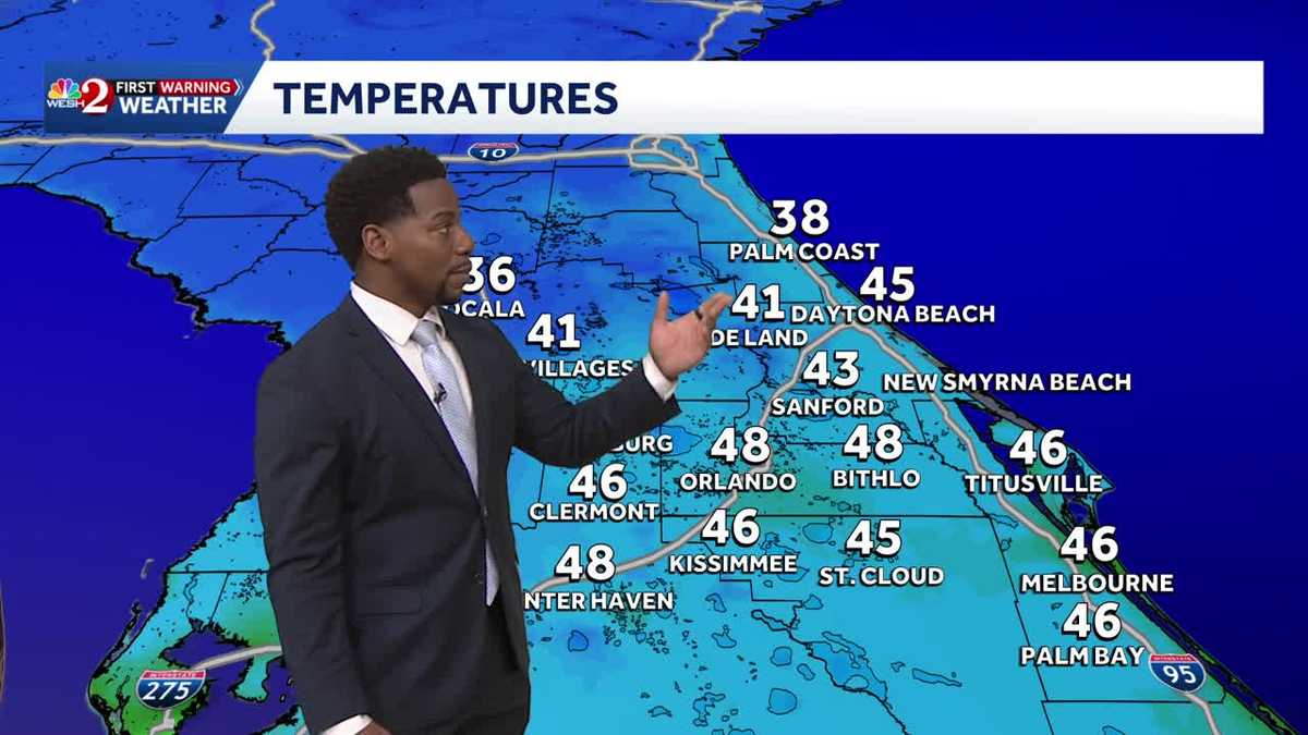
Central Florida begins the day with cold temperatures and frost concerns, as temperatures in the northern and western counties have fallen into the thirties.
It’s a clear start to the morning, so temperatures could still lose an extra degree or two before sunrise.
Sunshine will be plentiful today with an onshore flow, allowing temperatures to warm into the low seventies inland later this afternoon.
The warming trend will continue into the weekend, with peak temperatures reaching the mid and upper seventies on Saturday and Sunday.
However, a dry cold front will sneak into the picture as the weekend concludes, dropping temperatures into the lower sixties to start off the workweek.
First Warning Weather
Stay with WESH 2 online and on-air for the most accurate Central Florida weather forecast.
Download the WESH 2 News app to get the most up-to-date weather alerts.
The First Warning Weather team includes First Warning Chief Meteorologist Tony Mainolfi, Eric Burris, Marquise Meda and Cam Tran.