
Frosty Friday Start | Coolest Air of December So Far Ahead of a Weekend Warmup in Central Florida
Frosty Friday Start | Coolest Air of December So Far Ahead of a Weekend Warmup in Central Florida
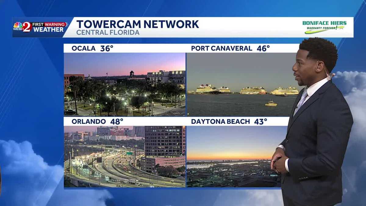
STUDIO THERE. ALLEN. YEAH, IT’S DEFINITELY SO EASY TO MAKE A DONATION REAL QUICKLY GOING THROUGH THAT DRIVE THROUGH. LET’S CHECK IN RIGHT NOW WITH FIRST WARNING METEOROLOGIST MARQUISE MEDA MARQUISE. THE SUN IS STARTING TO RISE, BUT THOSE COLDER TEMPERATURES ARE STILL LINGERING. YEAH, WE’RE GOING TO NEED A COUPLE EXTRA HOURS BEFORE THESE COOLER TEMPERATURES BEGIN TO WARM UP, BUT DO YOU HAVE A FAVORITE SUNRISE OUT OF THE PAIRING HERE, ELLEN. WE GOT OCALA, PORT CANAVERAL, ORLANDO DAYTONA BEACH. I DON’T KNOW, I MIGHT I MIGHT GO WITH DAYTONA MYSELF 43 DEGREES THOUGH. SO A LITTLE BIT COOL OUT ALONG THE COAST. OCALA CERTAINLY COOLER 36 OUT THAT DIRECTION HERE ACROSS TO TAVARES IN LAKE COUNTY. WE’VE GOT TEMPERATURES STILL STICKING AROUND THE 40S, BUT IT’S A GORGEOUS SUNRISE IN WHICH WE’RE SHOWING 45 DEGREE TEMPERATURES JUST TO YOUR SOUTH IN LEESBURG. THE COOLEST PLACES OF OCALA AND PALM COAST. AS YOU’RE STILL STUCK IN THE 30S THIS MORNING, AS YOUR CHRISTMAS DOES CONTINUE, EVENTUALLY WILL WARM TO THE MID 50S BY 9:00, AND WE’LL STILL BE BELOW OUR SEASONAL AVERAGE DESPITE THE SUNSHINE THIS AFTERNOON IN DAYTONA BEACH WITH HIGHS OF 69 DEGREES. SO DEFINITELY A COOLER FINISH TO YOUR WORKWEEK, BUT EVENTUALLY WE’LL SQUEEZE INTO THE 70S AS WE WRAP UP YOUR FRIDAY JUST A BIT BELOW YOUR SEASONAL AVERAGE. THIS WEEKEND, THOUGH, WARMER TEMPERATURES WILL BE BACK IN THE PICTURE. MILD ON SATURDAY AND SUNDAY AS WE RETURN TO THE MID AND UPPER 70S, BUT WATCH OUT FOR A COASTAL RAIN SHOWER ON SUNDAY AS YOU HEAD TOWARDS BREVARD COUNTY. HERE’S A LOOK AT YOUR WEEKEND WARM UP 72 FOR YOUR HIGH IN ORLANDO TODAY. MID 70S ON SATURDAY AND SUNDAY. SO A LOT TO LOOK FORWARD TO AS WE MOVE TOWARDS APOPKA FOR THE APOPKA CHRISTMAS PARADE IN ORANGE COUNTY TOMORROW. WILL BE COMFORTABLE IN THE AFTERNOON. LOOK FOR TEMPERATURES TO BE RIGHT AROUND 70 DEGREES. PERFECT WEATHER CONDITIONS BY NOONTIME. WHAT ABOUT THE START OF YOUR WORKWEEK? WELL, THAT’S WHEN WE’LL SEE SOME CHANGE COMING YOUR WAY HERE IN CENTRAL FLORIDA. A COLD FRONT IS GOING TO DESCEND TOWARDS THE SOUTH. WE MENTIONED THERE’S A SMALL CHANCE FOR A QUICK HITTING SHOWER SUNDAY AND MONDAY ALONG THE COAST, BUT PRIMARILY THIS IS GOING TO BE A DRY, COLD FRONT FOR US HERE IN CENTRAL FLORIDA. IT WILL, HOWEVER, BE A TEMPERATURE SHIFTING COLD FRONT, ALLOWING FOR HIGHS TO DROP DOWN INTO THE 60S BY MONDAY IN THE AFTERNOON. SO QUITE THE CHANGE COMING OUR WAY. SOME PEOPLE ARE LOOKING FORWARD TO THOSE TEMPERATURES. ME, I GOT ENOUGH OF THE COOLER WEATHER TODAY. AS FOR YOUR HOLIDAY COUNTDOWN, WE ARE NINE DAYS AWAY FROM THE START OF THE WINTER SEASON. THAT MEANS JUST AFTER THAT, WE ARE 13 DAYS AWAY FROM CHRISTMAS, 19 DAYS AWAY FROM NEW YEAR’S EVE, AND WE’VE GOT SOME WARMER TEMPERATURES COMING YOUR WAY. IN FACT, NEARLY ALL ACROSS THE COUNTRY WILL FEEL THAT WARM UP AS WE MOVE INTO THAT SECOND TO LAST WEEK OF DECEMBER. AND THAT INCLUDES US HERE IN CENTRAL FLORIDA AS WELL. BEFORE WE GET THERE, THOUGH, IT’S A COOL START TO YOUR MORNING. WE’RE BACK IN THE LOWER 40S ACROSS THE COAST. EVENTUALLY WILL WARM TO THE 70S THIS AFTERNOON. WE’LL KEEP THAT AROUND THIS WEEKEND, BUT WE DROP DOWN TO THE LOWER 60S O
Frosty Friday Start | Coolest Air of December So Far Ahead of a Weekend Warmup in Central Florida
Frosty Friday Start | Coolest Air of December So Far Ahead of a Weekend Warmup in Central Florida

Updated: 7:26 AM EST Dec 12, 2025
Frosty Friday Start | Coolest Air of December So Far Ahead of a Weekend Warmup in Central FloridaNo advisories issued for Central Florida to close out the workweek, but it is certainly a cold start to the morning. Temperatures in our north and western most counties have fallen into the thirties this morning with frost concerns. It’s a clear start to your morning, so we could still lose an extra degree or two before sunrise. Ultimately sunshine will be plentiful today with an onshore flow, therefore temperatures will warm into the low seventies inland later this afternoon. Our warming trend will follow us into the weekend with peak temps reaching the mid and upper seventies Saturday and Sunday. Don’t get too comfortable though, a dry cold front will sneak into the picture as the weekend comes to its conclusion. This will drop temps into the lower sixties to start off the workweek.
Frosty Friday Start | Coolest Air of December So Far Ahead of a Weekend Warmup in Central Florida
No advisories issued for Central Florida to close out the workweek, but it is certainly a cold start to the morning. Temperatures in our north and western most counties have fallen into the thirties this morning with frost concerns. It’s a clear start to your morning, so we could still lose an extra degree or two before sunrise. Ultimately sunshine will be plentiful today with an onshore flow, therefore temperatures will warm into the low seventies inland later this afternoon. Our warming trend will follow us into the weekend with peak temps reaching the mid and upper seventies Saturday and Sunday. Don’t get too comfortable though, a dry cold front will sneak into the picture as the weekend comes to its conclusion. This will drop temps into the lower sixties to start off the workweek.