
Wind Advisory in Place with Significant Temperature Dropoff Tonight | Cold Workweek Start in Central Florida
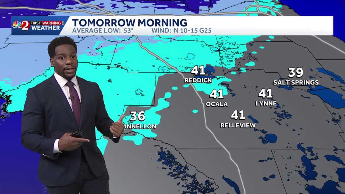
MEDIA. SPEAKING OF THOSE COOLER TEMPERATURES, WE HAVE MARQUISE MEDA JOINING US NOW. MARQUISE ONLY PARTS ARE REALLY GOING TO SEE THAT COLDER TEMPERATURE. YEAH, ESPECIALLY AS YOU HEAD FURTHER NORTH. RIGHT. THAT’S WHERE WE COULD HAVE THE CHANCE FOR MAYBE SOME WIND CHILL VALUES TO DIP BELOW 40 DEGREES. I’M TALKING ABOUT MARION COUNTY. ALSO FLAGLER. AND TO MAKE MATTERS EVEN WORSE, BUR SUMS IT UP PERFECTLY FINE, ESPECIALLY IF YOU’RE ALONG THE COAST. BECAUSE NOT ONLY WILL YOU BE TRENDING COOL, YOU’LL BE TRENDING QUITE WINDY. ALL OF OUR COASTAL COMMUNITIES FLAGLER, VOLUSIA, BREVARD YOU GUYS ARE UNDER A WIND ADVISORY THAT STARTS AT 7:00 TONIGHT AND CONTINUES ALL THE WAY THROUGH 9 A.M. TOMORROW. THESE GUSTS COULD BE UP TO 35, MAYBE EVEN 40MPH. AND TO MAKE MATTERS WORSE, WE’LL HAVE SOME ROUGH SEAS ALL ACROSS THE COAST AS WELL. SO IT’S GOING TO BE A BIT OF A BLUSTERY AND COLD START TO YOUR WORKWEEK. LARGE BREAKING WAVES ARE WHAT’S FORECASTED. THESE COULD BE ANYWHERE BETWEEN 7 AND 10FT HIGH. WE’LL SWING OUT TOWARDS THE COAST. RIGHT NOW WE HAVE CLEAR SKIES OVER VOLUSIA COUNTY HERE IN NEW SMYRNA BEACH. TEMPERATURE WISE, IT FEELS NICE. RIGHT NOW, 75 DEGREES. BUT YOU’LL BE LUCKY TO MAKE IT BACK INTO THE 50S EARLY. OUT THE DOOR TO START OFF THE MORNING TOMORROW. NOTICE UPPER 50S COMING YOUR WAY WITH BLUSTERY WINDS RIGHT AROUND THREE, FOUR AND 5:00. WE MENTIONED THOSE WIND GUSTS COULD BE UP TO 35MPH. LET’S TRACK THEM NOW ON FUTURECAST. NOT TOO MANY CLOUDS INLAND. YOU SEE THOSE CLOUDIER CONDITIONS ALONG THE COAST WITH MAYBE A SPRINKLE OF RAIN. KEEP IN MIND WE’RE WATCHING A COLD FRONT PASS THROUGH. THAT’S WHAT’S INCREASING YOUR WINDS. AND WE SEE THAT VERY SMALL CHANCE FOR SOME SHOWERS ALONGSIDE IT. THESE GUSTY WINDS, THOSE WILL REMAIN IN PLACE ALL NIGHT LONG. NOTICE THAT YOUR STRONGEST GUSTS INLAND ARE IN THE 20S ALONG THE COAST. WE’VE GOT A COUPLE GUSTS ABOVE 30MPH, SO IT WILL BE A WINDY START TO YOUR WORKWEEK. CHANCE FOR RAIN AS HIGHS ACROSS THE COAST, BUT INLAND YOU FEEL THE COOLER TEMPERATURES DUNNELLON 36 DEGREES. OCALA 41. YOUR AVERAGE LOW AROUND THIS TIME OF YEAR. THAT’S RIGHT AROUND 53 DEGREE TEMPERATURES WILL BE WELL BELOW AVERAGE IN SUMTER COUNTY TO 46 FOR LAKE PANASOFFKEE BUSHNELL AS WELL AS WE SWING OUT TOWARDS THE EAST, YOU’RE A TOUCH WARMER ALONG THE COAST, 50S AND 60S IN BREVARD COUNTY FOR MELBOURNE, 60 DEGREES. COCOA BEACH 62. TITUSVILLE, UPPER 50S 59. LOWER 50S. ONCE YOU SWING ALONG I-4 50 ON THE DOT FOR FOR WINDERMERE WINTER PARK 53 IS YOUR WAKE-UP TEMPERATURE IN ORLANDO TOMORROW. SO HERE’S THAT COLD FRONT. BY MONDAY MORNING IT’S WELL TO OUR SOUTH, AND THAT BLAST OF COOLER AIR. WELL, IT’S GOING TO COME WITH SOME STRONG WINDS AS THAT FRONT CONTINUES TO PUSH SOUTH. HIGH PRESSURE IS GOING TO DICTATE OUR FORECAST TO START OFF THE WORKWEEK. SO FOR THOSE OF US INLAND IT WILL BE MILD ONCE YOU GET INTO TUESDAY AND WEDNESDAY. AND WE WILL SEE THOSE WIND SPEEDS SUBSIDE. AND ONCE THEY DO, TEMPERATURES WILL BEGIN TO RISE AS WELL. WE’LL BE BACK IN THE 70S BY TUESDAY COMING UP, BUT WE WON’T MAKE IT OUT OF THE 60S TOMORROW. CLOUDY SKIES WILL BE PRESENT IN THE AFTERNOON SUNSHINE TO START OFF THE DAY. SUNNY, WINDY AND COOL HERE IN CENTRAL FLORIDA TOMORROW. HIGH TEMPERATURES ARE ABOUT TEN DEGREES BELOW YOUR SEASONAL AVERAGE. WE’LL HIT 64 IN THE AFTERNOON IN ORLANDO, AND THEN AS WE CONTINUE ACROSS THE WORKWEEK, WE HAVE VERY MINUSCULE CHANCES FOR RAIN ON THURSDAY AND FRIDAY. WE MIGHT SEE A COUPLE OF THOSE SHOWERS WORK THEIR WAY INLAND, BUT WHAT WE WILL SEE ARE WARMER TEMPERATURES AS WE GET READY FOR WINTER IN THE NEXT SEVEN DAYS. CHRISTMAS IS 11 DAYS AWAY. NEW YEAR’S EVE, 17 DAYS AWAY. AND THEN AS WE MOVE INTO CHRISTMAS WEEK, OVERALL, IT’S GOING TO BE VERY WARM HERE IN CENTRAL FLORIDA, AND WE’LL START TO SEE THOSE TEMPERATURES RISE ONCE YOU MOVE PAST MONDAY. 62 FOR YOUR HIGH TOMORROW, 69 ON TUESDAY, 70 FROM WEDNESDAY THROUGH NEXT SATURDAY. IN FACT,
Wind Advisory in Place with Significant Temperature Dropoff Tonight | Cold Workweek Start in Central Florida

Updated: 6:50 PM EST Dec 14, 2025
Wind Advisory in Place with Significant Temperature Dropoff Tonight | Cooler Workweek Start in Central FloridaWe hope you were able to enjoy the heat this weekend. Highs today found their way into the upper seventies both inland and along the coast. Tonight, a dry cold front will be pushing across the region, bringing strong gusty winds and cooler temperatures into the picture to start the workweek. Winds tonight will be between 15-25mph, with occasional gusts of 40 along the coast. For this reason, a Wind Advisory will be in place for coastal Flagler, Volusia, and Brevard Counties. We’ll start to see winds pick up at 7:00pm tonight and the advisory will be in place through 9AM tomorrow. Although this front will have very little rain chances, the bigger take away will be the temperature swing. Monday morning highs will plummet to the low/mid-sixties, with overnight lows (Monday into Tuesday) falling to the forties and fifties.
Wind Advisory in Place with Significant Temperature Dropoff Tonight | Cooler Workweek Start in Central Florida
We hope you were able to enjoy the heat this weekend. Highs today found their way into the upper seventies both inland and along the coast. Tonight, a dry cold front will be pushing across the region, bringing strong gusty winds and cooler temperatures into the picture to start the workweek. Winds tonight will be between 15-25mph, with occasional gusts of 40 along the coast. For this reason, a Wind Advisory will be in place for coastal Flagler, Volusia, and Brevard Counties. We’ll start to see winds pick up at 7:00pm tonight and the advisory will be in place through 9AM tomorrow. Although this front will have very little rain chances, the bigger take away will be the temperature swing. Monday morning highs will plummet to the low/mid-sixties, with overnight lows (Monday into Tuesday) falling to the forties and fifties.