
Breezy Workweek Finish + Holiday Travel Forecast | Central Florida Weather Dec 19th 2025
Breezy Workweek Finish + Holiday Travel Forecast | Central Florida Weather Dec 19th 2025
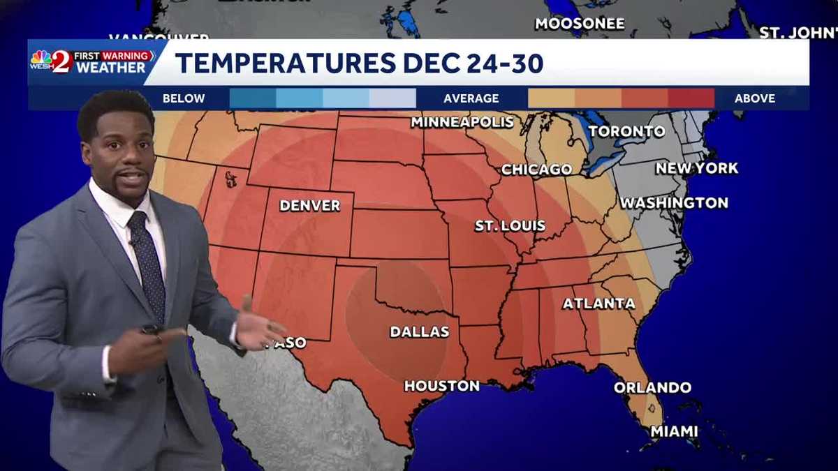
WE’RE GOING TO DO THIS, BUDDY. WE’RE GOING TO MAKE IT HAPPEN. ALL RIGHT, MARQUISE, LET’S SEND IT OVER TO YOU. NANCY. IT’S A BEAUTIFUL DAY FOR A WALK IN THE PARK WITH ZIG ZAG. MAYBE JUST NOT A BEAUTIFUL DAY FOR FRISBEE. WE’RE BREEZY HERE IN CENTRAL FLORIDA TODAY, SWINGING OUT TO MELBOURNE WHERE WE HAVE SUSTAINED WINDS OF 18MPH. BUT WE HAVE A LOT OF SUNSHINE BEGINNING TO EMERGE AS WELL. THAT’S WHAT’S PROPELLED TEMPERATURES INTO THE LOWER 80S, AND WE MAY SEE THESE RISE BY AN EXTRA DEGREE OR TWO BEFORE YOUR DAY IS SAID AND DONE. NOW, THE REASON WHY WE’RE TRENDING SO WINDY IS ALL COURTESY OF THIS FRONTAL BOUNDARY HERE, A COLD FRONT WHICH WILL SUBTRACT A FEW DEGREES OVER THE COURSE OF THE WEEKEND, PLACING US IN THE UPPER 70S. BUT THE BIGGER STORY FOR TODAY IS THE WINDS. WE HAVE A TIGHT PRESSURE GRADIENT SURROUNDING THIS COLD FRONT, AS DRY AIR STARTS TO FUNNEL IN FROM THE NORTH AND THE WEST. HERE’S A LOOK AT SOME OF THE MOST RECENT GUSTS THAT WE’VE SEEN. 25 IN SANFORD, MELBOURNE, 32 MILE PER HOUR CONDITIONS. WE ACTUALLY SAW GUST UP TOWARDS THE I-10 CORRIDOR JUST EAST OF LAKE CITY. THIS WAS ABOUT 44 45MPH. EARLIER THIS MORNING IN WATERTOWN. AND WE COULD SEE SOME OF THOSE BREEZY CONDITIONS DOWN HERE IN CENTRAL FLORIDA AS WELL, WITH THAT COLD FRONT PASSING THROUGH. BUT ONCE IT PUSHES TO THE SOUTH, WE’LL START TO SHOW THOSE CLOUDS BEGINNING TO SEPARATE LATER THIS AFTERNOON. AND WE’RE LEFT WITH SUNNY SKIES JUST BEFORE SUNSET AND MAYBE A SMALL BREEZE. TO START OFF YOUR SATURDAY MORNING. TEMPERATURE WISE THIS AFTERNOON THERE WILL BE BACK IN THE UPPER 70S AND LOWER 80S ALREADY BACK IN THE LOWER 80S IN MELBOURNE ALREADY. SO IT’S A VERY WARM FINISH TO YOUR WORK WEEK AND OVER THE COURSE OF THE REST OF YOUR EVENING, WE’LL SEE THOSE TEMPERATURES STUMBLE INTO THE 60S AND THE 50S OVERNIGHT. SO WITH CLEARER SKIES, WE’RE A LITTLE BIT COOLER TONIGHT THAN WE WERE YESTERDAY. THIS FRONT CONTINUES TO PUSH TOWARDS THE SOUTH. AND THERE YOU HAVE IT. SUNSHINE IS BACK ON YOUR WEEKEND FORECAST. STILL. WE’LL HAVE A NORTHERLY BREEZE THROUGHOUT THE WEEKEND, NORTH AND WESTERLY SATURDAY AND SUNDAY, KEEPING US A LITTLE BIT COOLER. SPEAKING OF COOL, WE’LL DROP ANYWHERE BETWEEN 43 AND 62 DEGREES TONIGHT UNDER CLEAR SKIES ONCE AGAIN. SO WE LET GO OF THE HEAT THAT WE ACCUMULATE THROUGHOUT THE DAY, BUT WE’LL BE WARMING BACK UP NICELY IN THE AFTERNOON TOMORROW. NOTICE THAT THE WIND SPEEDS AREN’T AS FAST TOMORROW AS WHAT WE’RE SEEING TODAY. SO MUCH MORE MILD CONDITIONS LIE AHEAD OF US ON SATURDAY AND SUNDAY. A COUPLE CLOUDS RETURN TO THE PICTURE SATURDAY NIGHT, BUT ULTIMATELY THROUGHOUT THE AFTERNOON, YOU’RE PERFECTLY CLOUD FREE. TO START OFF YOUR WEEKEND, HERE’S A LOOK AT THOSE MILD CONDITIONS AS HIGH PRESSURE SAGS TO THE SOUTH THIS WEEKEND THAT WILL KEEP THE SUNSHINE AROUND. WE HAVE ANOTHER FRONT TRYING TO WORK ITS WAY IN, BUT IT’S NOT GOING TO BE A GAME CHANGER FOR US HERE IN CENTRAL FLORIDA. MAYBE A COUPLE SHOWERS TO OUR NORTH ACROSS THE I-10 CORRIDOR. ULTIMATELY, YOU’RE WARMER ON SUNDAY THAN THE TEMPERATURES WE WILL SEE SATURDAY 77, SATURDAY 79 DEGREES ON SUNDAY. AND WE’RE COUNTING DOWN TO THE HOLIDAY SEASON SIX DAYS AWAY FROM CHRISTMAS, 12 FROM THE NEW YEAR IN WHICH ACROSS THAT STRETCH WILL BE TRENDING WARM HERE IN CENTRAL FLORIDA. HOW WARM? WELL, LET’S TAKE A LOOK AT YOUR SEVEN DAY CERTIFIED MOST ACCURATE FORECAST. WINTER BEGINS ON SUNDAY. WE’RE BACK IN THE UPPER 70S, A TOUCH COOLER TO START OFF THE WORKWEEK MONDAY, BUT AS WE HEAD INTO CHRISTMAS, WE’RE BACK IN THE UPPER 70S WEDNE
Breezy Workweek Finish + Holiday Travel Forecast | Central Florida Weather Dec 19th 2025
Breezy Workweek Finish + Holiday Travel Forecast | Central Florida Weather Dec 19th 2025

Updated: 3:18 PM EST Dec 19, 2025
Breezy Workweek Finish + Holiday Travel Forecast | Central Florida Weather Dec 19th 2025Just a bit breezy out the door today. With a weak cold front passing over the area, winds will be gusting upwards of 20 mph this afternoon as the sky begins to clear. Out across our northern most counties (Marion and Flagler) a Special Weather Statement has been issued with gusts possibly exceeding 40mph. Drier weather lies ahead of us this afternoon, which means that we’ll slowly start to show more sunshine as the day does progress. With that in mind high temperatures will squeeze into the upper seventies and the lower eighties today, with lows falling into the 50s under clear skies. As for your weekend, expect to be a touch cooler. Today’s cold front passing will place temps in the mid and upper seventies with consistent sunshine on Saturday and Sunday.
Breezy Workweek Finish + Holiday Travel Forecast | Central Florida Weather Dec 19th 2025
Just a bit breezy out the door today. With a weak cold front passing over the area, winds will be gusting upwards of 20 mph this afternoon as the sky begins to clear. Out across our northern most counties (Marion and Flagler) a Special Weather Statement has been issued with gusts possibly exceeding 40mph. Drier weather lies ahead of us this afternoon, which means that we’ll slowly start to show more sunshine as the day does progress. With that in mind high temperatures will squeeze into the upper seventies and the lower eighties today, with lows falling into the 50s under clear skies. As for your weekend, expect to be a touch cooler. Today’s cold front passing will place temps in the mid and upper seventies with consistent sunshine on Saturday and Sunday.