
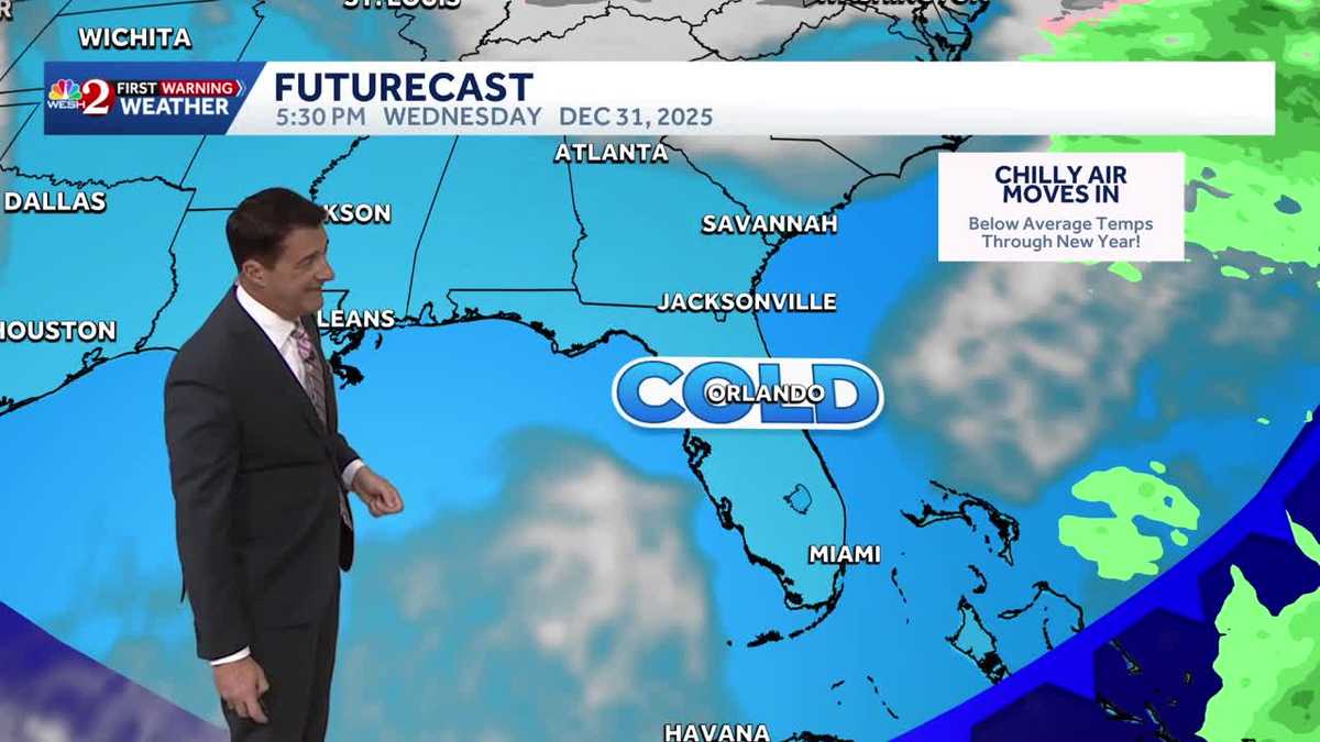
Timing out the cold blast moving into Central Florida this week
YOU’RE BRINGING BACK THAT COLD WEATHER. I AM. LET ME TAKE YOU BACK OUTSIDE. RIGHT. I GOT TO PICK ON HER. I HAVEN’T SEEN HER IN OVER A WEEK AND A HALF. IMPACT WEATHER. THAT’S WHAT WE HAVE GOING ON. THAT’S FOR WEDNESDAY MORNING. MAYBE EVEN THURSDAY MORNING AS WELL. WE’LL HAVE TO WAIT ON THE WINDS THERE TO SEE HOW COLD WE GET. BUT AGAIN, FOR FREEZING TEMPERATURES NOW UP TOWARDS THE OCALA SQUARE GET A LITTLE BIT OF LIGHT RAIN FALLING. NOW OUT AHEAD OF THAT FRONT, A FEW SHOWERS, CLOUDS ON THE ADVANCE NOW INTO THE METRO AREAS. LOOK AT THAT LOW 80S ORLANDO ON SOUTH AND EAST. BUT THAT POLAR PLUNGE IS ON THE WAY BEHIND THIS FRONT AT THE TOP OF THE HOUR THERE WE DID SHOW YOU THE TEMPERATURES NORTH AND WEST OF TOWN ALREADY IN THE 50S UP TOWARDS THE PANHANDLE. LOOK AT THE LINE OF RAIN NOW. THE VILLAGES, OCALA, BACK TOWARDS PALM COAST. LET’S GO AHEAD AND PUT IT INTO MOTION. MOVING ALONG AT A PRETTY GOOD PACE HERE. OFF TOWARDS THE EAST EAST NORTHEAST AT ABOUT 20 MILES AN HOUR. SO OCALA SALT SPRINGS A LITTLE BIT LATER ON, SORRENTO AND ALTOONA, YOU’LL GET IN ON THE RAIN. LOOK AT MOBILE, LOOK AT PANAMA CITY. YOU CAN SEE THE TEMPERATURES STARTING THEIR DOWNWARD TREND THERE. WHEREAS CENTRAL AND SOUTH FLORIDA IS STILL IN THE UPPER 70S AND LOWER 80S. WHEN YOU START SEEING THE BLUE, THAT’S THE SIGN OF THAT CHANGE AND THAT’S WHAT’S CURRENTLY GOING ON, COMPLIMENTS OF THE RAIN THAT IS NOW FALLING ACROSS PORTIONS OF THE NORTHERN REACHES OF OUR VIEWING AREA. YOU CAN SEE THOSE SHOWERS HERE KIND OF GO IN AND OUT, AND THEN THE PITTER PATTER OF RAIN WILL BEGIN TO END, I THINK RIGHT AROUND 11 OR 12 HERE IN THE METRO AREAS. THEN BY DAYBREAK, IT’S A NEW SEASON. TEMPERATURES WILL BE DROPPING THROUGH THE UPPER 40S TO ABOUT 45 OUT THE DOOR AT 7 A.M. WINTER GARDEN, 44, APOPKA 43 WEDGEFIELD COMING IN AT 44. WE WIDEN OUT THAT VIEW. MIDDLE AND UPPER 30S HERE, NORTH AND WEST OF TOWN, MIDDLE AND UPPER 40S, SOUTH AND EAST. SO TONIGHT AND TOMORROW. MILD TODAY. MUCH COLDER AIR FILTERING ON IN NOW. BREEZY AND COLDER. THAT’S GOING TO BE THE BIG STORY FOR TOMORROW. LET’S TAKE A LOOK AT THE AFTERNOON TEMPS TOMORROW. PARKA 59 WEDGEFIELD 60. POINCIANA COMING IN AT ABOUT 60 DEGREES. WE WIDEN OUT THAT VIEW. THE VILLAGE IS 58 AND TITUSVILLE COMING IN AT ABOUT 60. SO UPON FURTHER REVIEW, A LOT OF FOLKS ARE ASKING, IS THIS GOING TO STICK AROUND AS WE RING IN THE NEW YEAR? THE ANSWER IS DEFINITIVELY YES. WE ARE TALKING ABOUT TEMPERATURES AT MIDNIGHT HERE IN TOWN, RIGHT AROUND 40 WITH 30S NORTH AND WEST. SO TOMORROW, 60, WE GET YOU ON IN A NEW YEAR’S EVE, 59 FOR AN AFTERNOON HIGH NEW YEAR’S DAY COMING IN AT ABOUT 65. AND THEN WHEN YOU TAKE A LOOK NOW AT OCALA, 29, 58, 35, 65, WE’VE GOT THE POTENTIAL FOR FREEZING TEMPERATURES THERE. NEW YEAR’S EVE MORNING, NOT NEW YEAR’S EVE NIGHT. IT WILL BE CHILLY, BUT IT WON’T BE AS COLD RIGHT AROUND 40 IN THE METRO AREA. SO BECAUSE OF THAT, WE DO HAVE FREEZE WATCHES UP NORTH AND WEST OF TOWN. WHEN YOU LOOK AT THAT POTENTIAL THERE, YOU CAN SEE OCALA, THE VILLAGES, WILDWOOD, PORTIONS OF NORTHERN LAKE COUNTY. WOULDN’T EVEN BE SURPRISED IF THE WINDS GO LIGHT ENOUGH THAT THAT WOULD BE EXTENDED OVER TOWARDS INLAND VOLUSIA COUNTY. SO LET’S GO AHEAD AND TAKE A LOOK NOW AT THE COASTAL SEVEN-DAY FORECAST. AND NOTICE THE TREND HERE. CHILLY THROUGH FRIDAY MODERATING TEMPERATURES OVER THE WEEKEND. BY THEN WE COULD HAVE A COUPL
Timing out the cold blast moving into Central Florida this week

Updated: 4:28 PM EST Dec 29, 2025
Temperatures across Central Florida are expected to drop as we welcome a new year. A cold front will move in on Monday evening, sending temperatures between the mid-40s and lower 60s. >> Cold weather shelters openingNew Year’s Eve – WednesdayOn New Year’s Eve, expect to wake up to wind chill temperatures in the 20s and 30s. Temps will only reach 59 degrees. Because of that, the First Warning Weather team is calling for Impact Weather. A freeze watch has been issues for some areas: New Year’s DayOn New Year’s Day, we could see a little bit of frost. Overall, temperatures will be slightly warmer, reaching the mid-60s. Looking aheadTemps are expected to jump back into the mid to upper 70s over the weekend.First Warning Weather Stay with WESH 2 online and on-air for the most accurate Central Florida weather forecast.RadarSevere Weather AlertsDownload the WESH 2 News app to get the most up-to-date weather alerts. The First Warning Weather team includes First Warning Chief Meteorologist Tony Mainolfi, Eric Burris, Marquise Meda and Cam Tran.
Temperatures across Central Florida are expected to drop as we welcome a new year.
A cold front will move in on Monday evening, sending temperatures between the mid-40s and lower 60s.
>> Cold weather shelters opening
New Year’s Eve – Wednesday

WESH 2 News
Impact Weather on New Year’s Eve
On New Year’s Eve, expect to wake up to wind chill temperatures in the 20s and 30s.
Temps will only reach 59 degrees.
Because of that, the First Warning Weather team is calling for Impact Weather.
A freeze watch has been issues for some areas:

WESH 2 News
Freeze Watch NYE 2025
This content is imported from Twitter.
You may be able to find the same content in another format, or you may be able to find more information, at their web site.
New Year’s Day
On New Year’s Day, we could see a little bit of frost. Overall, temperatures will be slightly warmer, reaching the mid-60s.
This content is imported from YouTube.
You may be able to find the same content in another format, or you may be able to find more information, at their web site.
Looking ahead
Temps are expected to jump back into the mid to upper 70s over the weekend.
This content is imported from Twitter.
You may be able to find the same content in another format, or you may be able to find more information, at their web site.
First Warning Weather
Stay with WESH 2 online and on-air for the most accurate Central Florida weather forecast.
Download the WESH 2 News app to get the most up-to-date weather alerts.
The First Warning Weather team includes First Warning Chief Meteorologist Tony Mainolfi, Eric Burris, Marquise Meda and Cam Tran.