
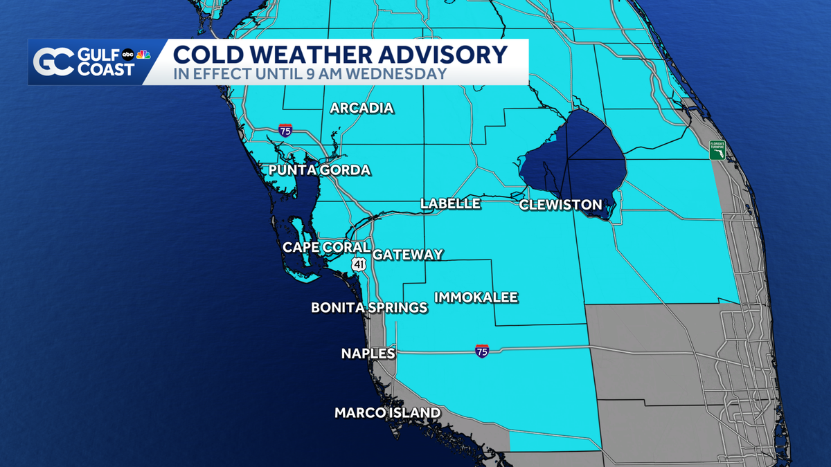
Cold weather advisory issued for SW Florida as 2025 wraps up with coldest air of season
Temperatures will plummet into the 30s overnight with patchy frost possible inland.
PRESSURE WHEN THE TEMPERATURE DROPS. AND SARAH, I’M NOT A FAN OF THE COLD WEATHER. >> WHAT DO SEE ME THERE? WELL, IT IS GOLD OUTSIDE. WE’RE ALREADY STARTING TO FEEL IN THE 40’S AND SOME OF OUR INLAND COMMUNITIES TOWARD BUCKINGHAM UNTOWARD ALVA. AND IT ONLY GETS COLDER FROM HERE ON OUT. TEMPERATURES ARE GOING TO CONTINUE TO FALL WHEN YOU ACCOUNT FOR THE BREEZE AND THE COOL WEATHER AS WELL AS THAT DRY CONDITIONS OUTSIDE. >> I DO FEEL IN THE 30’S MAYBE IN THE 20’S FOR SOME AREAS OF NORTH. NOW, BY FAR THE COLDEST FEEL-LIKE TEMPERATURES WILL BE IN OUR INLAND COMMUNITIES WERE TALKING ABOUT LABELLE AND PALMDALE. BUT STILL IT’S GOING TO BE CHILLY ALL ACROSS THE GULF COAST TO FEEL ABOUT. 29, WHEN YOU WAKE UP TOMORROW MORNING IN PORT CHARLOTTE AND DEEP CREEK, THE SAME STORY FOR ARCADIA IN LEE COUNTY. THE ONLY FEELING A COUPLE OF DEGREES WARMER, BUT STILL 33 IN GATEWAY AND IT’S FEELING AT 35 OUT THE DOOR IN FORT MYERS FOR YOUR FINAL DAY OF 2025. SO NEW YEAR’S EVE, WE ARE UNDER A GULF COAST WEATHER IMPACT DAY ALL THE WAY THROUGH THE MORNING. WE HAVE A COLD WEATHER ADVISORY THAT EXPIRES AT 9 THAT WILL DROP THE GULF COAST FOR THEIR IMPACT TODAY WE SHAKE OFF SOME OF THE CHILL AROUND LUNCH TOMORROW. BUT WE ARE GOING TO STRUGGLE TO GET WARMER THAN THE MID 60’S. WE’LL TOP OUT AROUND 63. 64 DEPENDING ON WHERE YOU ARE SLIGHTLY COOLER NORTH TOWARD DESOTO AND CHARLOTTE COUNTIES. WE’LL MAKE IT UP TO ABOUT 63 IN GORDA. BUT ONLY 65 IN AREAS AS FAR SOUTH AS MARCO ISLAND. THAT WHAT’S GOING TO BE COLD IN FORT MYERS? WE’RE FORECASTING 64 DEGREES, WHICH WOULD BE COLDEST NEW YEAR’S EVE THAT WE’VE SEEN SINCE 2001, A MAKE SURE YOU ARE BUNDLING UP BECAUSE IT IS GOING TO BE A VERY CHILLY DAY. NOW, IF YOU’RE HEADING OUT AND ABOUT TO RING IN 2026, IT WILL BE COOL AND DRY, BUT IT WILL BE FRIGID OUTSIDE. WE’RE TALKING ABOUT THE 50’S AROUND 07:00PM AND THEN WE OFFICIALLY MAKE IT TO NEXT YEAR. TEMPERATURES WILL BE ALL THE WAY INTO THE MID 40’S. NOW, IF YOU ARE RINGING IN THE NEW YEAR WITH SPARKLERS, FIREWORKS OR ANYTHING, THAT’S FLAMMABLE, MAKE SURE YOU’RE USING CAUTION. FIRE DANGER WILL BE A BIT ELEVATED TOMORROW ALL ACROSS THE GULF TOAST OR TALKING ABOUT A LEVEL 2 5 RISK OUT THERE. THAT’S BECAUSE WE’RE TRACKING PLENTY OF GUSTY WINDS THAT ARE COMING OUT OF THE NORTH. AND THAT’S GOING TO KEEP OUR HUMIDITY LOW. THAT’S THE PERFECT CONDITION FOR A SPARK TO SPREAD. SO MAKE SURE THAT YOU ARE USING FIRE RESPONSE TO PLAY OUT AND MAKE SURE THAT YOU’RE BUNDLING UP FOR YOUR PETS INSIDE, TOO, BECAUSE IT IS CHILLY OVERNIGHT. TEMPERATURES ARE PULL A MEETING DOWN INTO THE UPPER 30’S, BUT IT’LL FEEL LIKE THE 20’S WHEN WE’RE WAKING UP TOMORROW MORNING, WE’RE BACK INTO THE MID 60’S BY WEDNESDAY AFTERNOON, THE FIRST AFTERNOON OF 2026. ISN’T THAT MUCH WARMER? STILL LOOKING AT THE UPPER 60’S AND 70’S RETURN BY FRIDAY AFTERNOON. WE CONTINUE TO WARM UNTI
Cold weather advisory issued for SW Florida as 2025 wraps up with coldest air of season
Temperatures will plummet into the 30s overnight with patchy frost possible inland.

Updated: 11:39 PM EST Dec 30, 2025
Get ready for the coldest air of the season overnight, with low temperatures Wednesday morning ranging from the low 40s near the coast to near-freezing for some of our inland neighborhoods.With the wind factored in, it will feel even colder. A cold weather advisory is in effect from midnight until 9 a.m. Wednesday for most of Southwest Florida.New Year’s Eve will stay unseasonably cool, with daytime highs only reaching the mid-60s.If you are heading out to celebrate the New Year, make sure to bundle up. Temperatures at midnight will be in the mid-40s, so get ready for a cold start to 2026!We will be slow to warm back up with seasonal highs in the mid-70s returning for the weekend. Slim rain chances will return this weekend as a weak cold front works through the Gulf Coast. Live Interactive RadarCheck out the interactive Gulf Coast Live RadarWatch your Gulf Coast Weather forecasts on TV or onlineHere’s where to find our latest weather forecast videoYou can also watch newscasts live or on demand hereOr download the Gulf Coast News app to stream on your phone or tabletYour Gulf Coast Storm TeamChief Meteorologist Allyson RaeMeteorologist Caroline CastoraMeteorologist Jim DickeyMeteorologist Jason DunningMeteorologist Lauren HopeMeteorologist Raphael TavernierMeteorologist Rob DunsMeteorologist Sara BlueDOWNLOAD the free Gulf Coast News app for your latest breaking news and weather alerts. And check out the Very Local Gulf Coast app to stream news, entertainment and original programming on your TV.
Get ready for the coldest air of the season overnight, with low temperatures Wednesday morning ranging from the low 40s near the coast to near-freezing for some of our inland neighborhoods.
With the wind factored in, it will feel even colder. A cold weather advisory is in effect from midnight until 9 a.m. Wednesday for most of Southwest Florida.
New Year’s Eve will stay unseasonably cool, with daytime highs only reaching the mid-60s.
If you are heading out to celebrate the New Year, make sure to bundle up. Temperatures at midnight will be in the mid-40s, so get ready for a cold start to 2026!
We will be slow to warm back up with seasonal highs in the mid-70s returning for the weekend. Slim rain chances will return this weekend as a weak cold front works through the Gulf Coast.
Live Interactive Radar
Watch your Gulf Coast Weather forecasts on TV or online
Your Gulf Coast Storm Team
DOWNLOAD the free Gulf Coast News app for your latest breaking news and weather alerts. And check out the Very Local Gulf Coast app to stream news, entertainment and original programming on your TV.