
ORLANDO, Fla. – Winds have already started to change as our next cold front makes its approach from the northwest. Currently, it’s centered over the Deep South and Dixie Alley Regions, dumping heavy rain and producing severe weather tonight.
Thankfully, we won’t receive any of the nasty weather, but our chance for some isolated showers and stray thunderstorms will pick up, especially tomorrow after about 5 p.m.
There’s been a distinct change in our wind flow across the state, showing the presence of a front and supporting upper level trough nearby (Copyright WKMG 2025)
The front is slated to start sliding across the Florida panhandle in the morning, and by 2 p.m. we’ll probably begin to see the nose of that cool pool back behind the cold front showing up on radar northwest of Gainesville. Then after this it starts to dip into our viewing area, with Marion county right up next.
It looks like our computer models expect it to lose some steam the further south it goes. However, we’ll still see winds pick up and warmer temperatures tomorrow before it completely moves through our neighborhood and south.
The cold front coming down should be directly overhead towards the late afternoon, early evening when the shot for some rains in Central Florida will also be greatest. (Copyright WKMG 2025)
Then we’ll see winds shift to a northerly direction all over again, and dry air will clear the skies for us into the work week ahead.
There could be some leftover moisture hanging out over the northern half of the peninsula, which might produce overnight rains and some very light showers as you start your Monday. I’m skeptical of this though, given how potent of a front and supporting trough we have coming down.
Into the mid section of our upcoming new week, the front may try to retrograde some and slide back towards the north over the Florida peninsula which will keep temperatures on the higher end at least till Thursday.
Looking ahead for the rest of the month, towards Halloween night, we should remain in somewhat below average temperatures for the next few weeks which is AMAZING news leading up to the big day. (Copyright WKMG 2025)
We’ve got a reinforcing shot of cooler, drier air from up north ready to come down once again and push a lot of that leftover tropical air back where it belongs.
This could also get a little tricky for Invest 98L moving into the Caribbean by tomorrow as well. Models show progressive systems moving through the northern United States, driving fields of cooler air down towards us in Florida. As these fronts continue west to east, they tend to guide tropical features.
As Invest 98L develops these fronts will be key, as well as the high pressure centers back behind them.
Formation chances continue to rise for newly designated Invest 98L headed for the Caribbean. (Copyright WKMG 2025)
All in all however, your Sunday shouldn’t be a wash out. The start of your new work and school week looks pretty good as well, with another healthy dose of fall weather conditions arriving by Thursday.
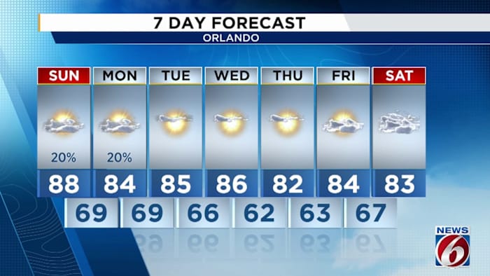
Daily Forecast
The News 6 Weather team ensures you’re always on top of the day’s weather.
Copyright 2025 by WKMG ClickOrlando – All rights reserved.