
Foggy mornings ahead for Southwest Florida
Expect low visibility for parts of the Gulf Coast this week.
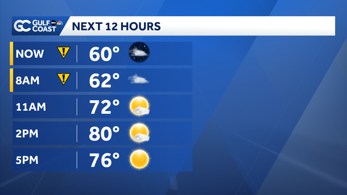
ABSOLUTELY. I CAN’T WAIT TO HATE. WATCH SOME RED SOX SPRING TRAINING. SPRING TRAINING. SO GREAT BECAUSE IT’S A SMALLER VENUE AND YOU GET TO SEE THEM MORE UP CLOSE AND WE HAVE BEAUTIFUL WEATHER THAT’S IT’S GOING TO FEEL LIKE SPRING TODAY. HEARD TRACK IN 80 DEGREE WEATHER THIS AFTERNOON. >> OUR NEXT COLD FRONT COMING EVENTUALLY. WE’LL TALK ABOUT THAT A BIT OUT THE DOOR THIS MORNING. FIRST THING YOU NEED TO KNOW IS GOING TO BE TRACKING SOME AREAS OF FOG. >> SIMILAR TO YESTERDAY MORNING AND MOST OF IT’S GOING TO STICK AROUND THROUGH ABOUT 9 O’CLOCK. SO SOME NEIGHBORHOODS, IT’S GOING TO BE A GREY AND SORT OF A GLOOMY START. THE NEXT IMPACT WEATHER FOR US. WIDESPREAD FOG OVERNIGHT INTO WEDNESDAY MORNING. LIKELY AFTER ABOUT 03:00AM. AND I THINK IT’S GOING TO BE A LOT THICKER WITH THAT FOG TOMORROW MORNING AND AGAIN, MORE WIDESPREAD AND THEN THE NEXT COLD FRONT ARRIVING LATE MONDAY AND INTO MONDAY MORNING. SO UNTIL THEN, WE’RE LOOKING AT 80’S ALL THE WAY THROUGH SATURDAY. LET’S CHECK SOME OF THE FOG WE HAVE OUT THERE THIS MORNING AND LOOKING PRETTY GOOD, ACTUALLY, FOR THOSE OF US CLOSER TO THE COAST, THE FOG IS LIGHTER. YOU CAN SEE IT’S A BIT THICKER IN THE AREAS THAT HAVE GOT SHADED IN YELLOW. THIS IS AROUND PALMDALE AND LABELLE AROUND HIGHWAY 27 AND JUST TO THE WEST OF LAKE OKEECHOBEE. BUT I THINK THIS WILL CONTINUE TO EXPAND AS WE GO THROUGH THE MORNING. AND HERE’S A PREVIEW. WHAT TO EXPECT OVER THE NEXT COUPLE HOURS. THE KIDS ARE HEADING BACK TO THE BUS. STOP ONE BACK TO SCHOOL TODAY FOR MOST OF THE GULF COAST. THIS AROUND 8 O’CLOCK YOU SEE FOR PARTS OF LEE, CHARLOTTE AND COLLIER COUNTY WILL SEE SOME FOGGY CONDITIONS BEFORE IT ALL STARTS TO BREAK UP AND LEFT BY AROUND 10 TO 11:00AM. TEMPERATURES RIGHT NOW. A LITTLE CHILLY PROBABLY WANT TO AT LEAST A LIGHT JACKET. LONG SLEEVES ARE STARTING OFF IN THE 50’S. 56 NORTH FORT MYERS, 57 BUCKINGHAM AND 60 RIGHT NOW IN THE VILLAS, 53 GORDA. SO GOING UP A LITTLE BIT COOLER UP THERE ACROSS PARTS OF CHARLOTTE COUNTY RIGHT NOW. SO I’VE GOT THE ICONS HERE JUST TO SHOW YOU THAT THAT WE’RE GOING TO HAVE THOSE FOGGY CONDITIONS. STILL ABOUT 8 TO 9 O’CLOCK. 11:00AM SUNNY 72. AND THEN BY 2 O’CLOCK HENNINGER, HIGH OF 80 DEGREES ABOUT 5 DEGREES ABOVE AVERAGE OR AVERAGE HIGH FOR JANUARY, WHICH IS THE COLDEST MONTH FOR US OUT OF THE YEAR IS 75. WE’LL SEE THAT BREEZE OUT OF THE WEST-SOUTHWEST TODAY. FAIRLY LIGHT AT 6 MILES PER HOUR. AND THOSE TEMPS RANGING ANYWHERE FROM 79 TO 82 DEGREES. ALL RIGHT. SO LET’S WALK YOU THROUGH THE DAY WITH OUR GULF COAST FUTURE CAST. YOU CAN SEE SOME OF THAT EARLY MORNING FOG AND THEN TURNING SUNNY, WE’RE NOT TRACKING ANY RAIN OUT THERE TODAY, AT LEAST ON OUR COAST. THAT COULD BE A COUPLE OF SHOWERS SOUTH OF LAKE OKEECHOBEE. AND THEN TOMORROW MORNING, THIS 03:00AM NOTICE HOW THE FOG REALLY BUILDS. AND YOU CAN SEE IT SHADED IN WHITE HERE ANYWHERE FROM THE LAKE OUT CLOSER TO THE COAST. AND THAT COULD STICK AROUND THROUGH ABOUT 10 TO 11 O’CLOCK TOMORROW MORNING. SO FOR TODAY, JUST KIND OF RECAP AREAS OF FOG UNTIL 9 TO 10, THEN TURNING SUNNY AND WARM. A HIGH OF 80 UPPER 50’S TONIGHT. MORE WIDESPREAD FOG. I THINK WE’LL LIKELY HAVE A DENSE FOG ADVISORIES FOR ENTIRE GULF COAST. START THE MORNING TOMORROW. AND THEN ANOTHER WARM DAY UP TO 80 DEGREES. I WISH I HAD BETTER NEWS WITH RESPECT TO OUR RAIN. CHANCES. BUT LOOKING VERY SLIM ALL THE WAY THROUGH SATURDAY AND EVEN AND SO THE COAST, 7 DAY FORECAST, YOU CAN SEE THE FOGGY CONDITIONS EARLY TOMORROW THURSDAY, TEMPERATURES HIT A LITTLE BOOST, TOO. FOR THE 2ND HALF OF THE WEEK IN THE MID 80’S. AND THEN ONCE THAT COLD FRONT ARRIVES LATE SUNDAY, WE’LL SEE TEMPERATURES TAKE A DIVE DOWN
Foggy mornings ahead for Southwest Florida
Expect low visibility for parts of the Gulf Coast this week.

Updated: 5:40 AM EST Jan 6, 2026
We’ll track very foggy mornings and sunny afternoons this week across Southwest Florida. Visibility will drop below a quarter mile in spots Tuesday morning before sunshine finally breaks through by mid-morning. Afternoon temperatures stay above average this week, with 80s for highs over the next several days. Tonight into Wednesday morning, the fog looks to be very widespread. Prepare for reduced visibility during the morning commute through 9 to 10 a.m.Our next cold front will be here Sunday, bringing us some cooler weather to start next week.Rain chances steer clear of the Gulf Coast for the foreseeable future, so we’ll need to keep a close eye on the drought situation until we’re able to get some beneficial rain.Live Interactive RadarCheck out the interactive Gulf Coast Live RadarWatch your Gulf Coast Weather forecasts on TV or onlineHere’s where to find our latest weather forecast videoYou can also watch newscasts live or on demand hereOr download the Gulf Coast News app to stream on your phone or tabletYour Gulf Coast Storm TeamChief Meteorologist Allyson RaeMeteorologist Caroline CastoraMeteorologist Jim DickeyMeteorologist Jason DunningMeteorologist Lauren HopeMeteorologist Raphael TavernierMeteorologist Rob DunsMeteorologist Sara BlueDOWNLOAD the free Gulf Coast News app for your latest breaking news and weather alerts. And check out the Very Local Gulf Coast app to stream news, entertainment and original programming on your TV.
FORT MYERS, Fla. —
We’ll track very foggy mornings and sunny afternoons this week across Southwest Florida.
Visibility will drop below a quarter mile in spots Tuesday morning before sunshine finally breaks through by mid-morning.
Afternoon temperatures stay above average this week, with 80s for highs over the next several days.
Tonight into Wednesday morning, the fog looks to be very widespread. Prepare for reduced visibility during the morning commute through 9 to 10 a.m.
Our next cold front will be here Sunday, bringing us some cooler weather to start next week.
Rain chances steer clear of the Gulf Coast for the foreseeable future, so we’ll need to keep a close eye on the drought situation until we’re able to get some beneficial rain.
Live Interactive Radar
Watch your Gulf Coast Weather forecasts on TV or online
Your Gulf Coast Storm Team
DOWNLOAD the free Gulf Coast News app for your latest breaking news and weather alerts. And check out the Very Local Gulf Coast app to stream news, entertainment and original programming on your TV.