
Another blast of cold weather expected to hit Central Florida
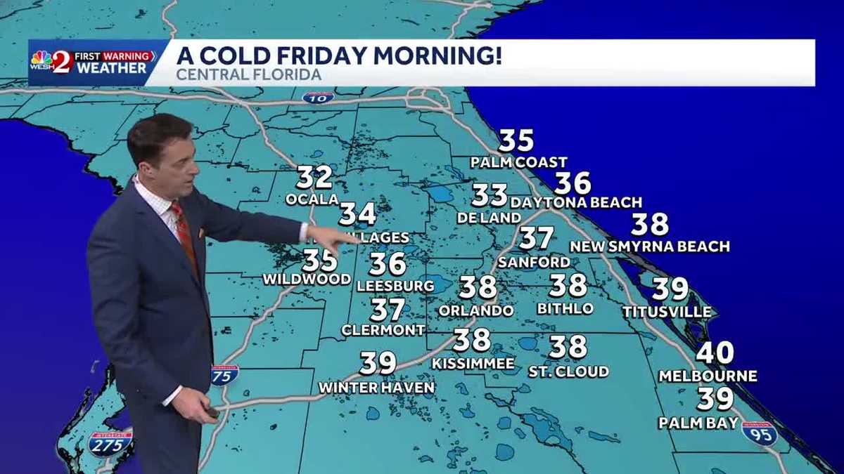
DO NOT PUT AWAY THE SCARVES AND THE TOBOGGANS JUST YET, BECAUSE IT’S REALLY GOING TO GET COLD OUT THERE. AND IT’S GOING TO FEEL A LOT LIKE WINTER. SO, YOU KNOW WE HAVE TWO FRONTS. THE FIRST FRONT COMING THROUGH TOMORROW IS GOING TO GET US BACK TO NORMAL FOR MONDAY. IT’S GOING YOU’RE GOING TO NOTICE A CHANGE. BUT BUT BY THE TIME WE GET TO FRIDAY, THE HEATERS ARE COMING ON. LET ME SHOW YOU THE HAND WARMERS OUT. YEAH. OH, BOY. I TELL YOU WHAT. PEOPLE ARE LAUGHING AT US. ANYWAY, LISTEN, LET’S SHOW YOU WHAT’S GOING ON. LET’S GET REAL SERIOUS ABOUT THAT. HERE’S YOUR FIRST DIP. THIS BIG RIDGE OF HIGH PRESSURE WE HAD THAT IS STARTING TO BREAK DOWN NOW AND THEN AS WE GO THROUGH THE DAY TOMORROW, YOU CAN SEE THAT BIG WARM RIDGE GETTING DEFLECTED TO THE SOUTH. WE START TO COOL DOWN AND THEN HERE COMES ANOTHER PIECE OF ENERGY COMING STRAIGHT OUT OF CANADA AND DROPPING SOUTHWARD DURING THE DAY ON THURSDAY. THAT IS GOING TO BE THE REAL DEAL. WE’VE HAD REALLY GOOD CONSISTENCY NOW WITH BOTH THE EUROPEAN AND THE GFS FOR THIS PARTICULAR FEATURE TO DIG TO THE SOUTH. SO MONDAY MORNING BEHIND FRONT ONE, WE’RE IN THE UPPER 30S BACK TO NORMAL AND UPPER 40S TO LOW 50S HERE IN TOWN. SO THERE’S THE FIRST FRONT. THERE GOES THE HIGH OFF TO OUR EAST. HERE COMES THE NEXT WEATHER MAKER. TWO PERIODS OF RAIN, ONE WEDNESDAY AND A QUICK LITTLE SHOT WITH THE FRONT THERE ON THURSDAY. BEHIND THIS. HERE’S WHERE IT GETS COLD. POTENTIAL FREEZE THERE IN MARION COUNTY. 33 TO 38 ORLANDO 38 BITHLO FACTOR IN THE WIND. FOR RIGHT NOW WE’RE TALKING ABOUT WIND CHILLS IN THE 20S AND 30S. OF COURSE, THIS COULD CHANGE EITHER WAY, BUT THE TREND SINCE YESTERDAY HAS BEEN JUST A LITTLE BIT COLDER. KEEP CHECKING BACK IN. OF COURSE, WE’LL LET YOU KNOW IF OLD MAN WINTER IS STICKING AROUND FOR A SHORT DURATIO
Another blast of cold weather expected to hit Central Florida

Updated: 10:42 PM EST Jan 10, 2026
Enjoying the warm Central Florida winter weather? Don’t get too comfortable. A significant cool down is expected to begin on Sunday, leading into a much chillier week.Prepare for a return to winter conditions as a cold blast is expected to arrive next Friday morning. Low temperatures are expected to drop into the 30s and 40s across Central Florida.Keep your sweaters, jackets and boots ready for the upcoming week.First Warning Weather Stay with WESH 2 online and on-air for the most accurate Central Florida weather forecast.RadarSevere Weather AlertsDownload the WESH 2 News app to get the most up-to-date weather alerts. The First Warning Weather team includes First Warning Chief Meteorologist Tony Mainolfi, Eric Burris, Marquise Meda and Cam Tran.
CENTRAL FLORIDA, USA —
Enjoying the warm Central Florida winter weather? Don’t get too comfortable. A significant cool down is expected to begin on Sunday, leading into a much chillier week.
Prepare for a return to winter conditions as a cold blast is expected to arrive next Friday morning. Low temperatures are expected to drop into the 30s and 40s across Central Florida.
Keep your sweaters, jackets and boots ready for the upcoming week.

From WESH
Cold front coming to Central Florida
First Warning Weather
Stay with WESH 2 online and on-air for the most accurate Central Florida weather forecast.
Download the WESH 2 News app to get the most up-to-date weather alerts.
The First Warning Weather team includes First Warning Chief Meteorologist Tony Mainolfi, Eric Burris, Marquise Meda and Cam Tran.