
Hello, Invest 98L. A system is brewing in the tropics that may or may not become the next named storm this hurricane season.
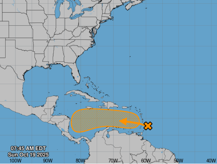
On Sunday, Oct. 19, the National Hurricane Center in Miami, Florida, was tracking a tropical wave, referred to as “AL98” on the organization’s site and also known as “Invest 98L,” near the Windward Islands and the Caribbean Sea. The tropical wave continues to produce a large area of showers and thunderstorms.
Though no storms have made landfall this hurricane season, it’s been an active one.
More than four months after the start of the 2025 Atlantic hurricane season, there have been several hurricanes and tropical storms churning in the tropics, but none have hit land.
The 8 a.m. Sunday, Oct. 19, 2025, tropical weather advisory from the National Hurricane Center shows the tropical wave, currently in the Caribbean Sea, has a low chance of formation within 48 hours and a medium chance of formation within the next seven days.
The hurricane center graphics and live weather radars below show what’s swirling in the tropics as well as the conditions for potential rain, flash flood and other warnings.
➤ 2025 Atlantic hurricane season predictions
Atlantic hurricane season is from June 1 to Nov. 30 every year, with the most activity between August and October. Should another weather system develop into a tropical storm, the system would be named Melissa, which is next on the list of the 2025 Atlantic hurricane season names (see below).
➤ Weather alerts via text: Sign up to get updates about current storms and weather events by location
Keep reading for information about tropical storm activity for Sunday, Oct. 19, 2025.
National Hurricane Center in Miami, Florida, forecast on tropical activity: Is there a tropical storm or hurricane now?
According to the Sunday, Oct. 19, 2025, tropical outlook from the National Hurricane Center in Miami, Florida, experts are keeping an eye on a tropical wave, Invest 98L or AL98 on the NHC site, churning in the Caribbean. The graphic above automatically updates with the most recent location for any or all disturbances.
The Atlantic basin consists of the northern Atlantic, Caribbean Sea and Gulf of America. NOAA changed its naming convention for the Gulf of Mexico after the U.S. Geological Survey changed the name on U.S. maps per President Trump’s order.
The Sunday, Oct. 19, advisory from the National Hurricane Center states:
“Near the Windward Islands and the Caribbean Sea (AL98): A tropical wave currently located near the Windward Islands is producing a large area of showers and thunderstorms. Heavy rainfall and gusty winds are expected today continuing through Monday morning across portions of the Windward and Leeward Islands as the system moves quickly westward at 20 to 25 mph into the eastern Caribbean Sea. Additional development is forecast to be limited over the next day or two, due to the fast forward motion of the wave. The system is then expected to slow down over the central Caribbean Sea during the middle portion of the week, where environmental conditions could become more conducive for development. A tropical depression could from over the central Caribbean Sea by the middle to latter portion of this week.”
Formation chance through 48 hours is low at 10 percent.
Formation chance through 7 days is medium at 60 percent.
The USA TODAY Network in Florida will produce daily tropics watch advisories.
Spaghetti models for Invest 98L or AL98 in the Caribbean
Special note about spaghetti models: Spaghetti model illustrations include an array of forecast tools and models, and not all are created equal. The Hurricane Center uses only the top four or five highest performing models to help make its forecasts.
Stay informed. Get weather alerts via textWhat’s next?
We will provided tropical weather coverage daily until Nov. 30 to keep you informed and prepared. Download your local site’s app to ensure you’re always connected to the news. And look for our special subscription offers here.
Contributing: Cheryl McCloud, USA TODAY Network-Florida
This article originally appeared on The Daytona Beach News-Journal: Spaghetti models for Invest 98L. Next hurricane name is Melissa