
Snowfall in Florida? Cold blast could bring wintery weather to the Sunshine State
APPROACH IN VENEZUELA. FIRST WARNING CHIEF METEOROLOGIST TONY MAINOLFI HERE. TONY. ALL EYES ARE ON THIS CRAZY COOLDOWN THAT’S COMING THURSDAY NIGHT INTO FRIDAY. YEAH, I MEAN, IT’S IT’S GOING TO BE A SHOCK TO THE SYSTEM. AND IT’S BEEN A LONG TIME SINCE WE’VE BEEN THIS COLD. GUYS, LET’S BEGIN NOW WITH THE IMPACT WEATHER GRAPHIC. THIS IS HOURS AWAY FROM BEING UPGRADED TO A SEVERE WEATHER WARNING DAY BECAUSE OF THE IMPENDING FREEZE WARNINGS AND WIND CHILLS THAT WILL BE IN THE 20S FOR A PROLONGED PERIOD OF TIME. SO WHERE EXACTLY IS THAT COLD AIR AND WHERE IS IT COMING FROM? WELL, YOU CAN SEE HUDSON’S BAY, THE GREAT LAKES. THIS IS DROPPING SOUTHWARD RIGHT NOW AND IS IN ROUTE TO CENTRAL FLORIDA. HERE, BY THE TIME WE GET YOU IN FRIDAY MORNING, YOU ARE GOING TO KNOW THAT THE ARCTIC PLUNGE IS HERE. THERE’S THE FRONT. LOOK AT THE SNOW NOW THROUGH THE OHIO VALLEY, WEST VIRGINIA, THE MOUNTAINS OF BOTH KENTUCKY AND TENNESSEE GETTING WHITE. AND RIGHT NOW FOR US, THIS IS SOME PRE-FRONTAL RAIN OUT AHEAD OF THAT ARCTIC BLAST. THERE. YOU CAN SEE A LITTLE BIT OF RAIN. NOW. PORT SAINT JOHN, CAPE CANAVERAL. IT EXTENDS OFF TOWARDS THE SOUTH AND WEST OVER THE FLORIDA TURNPIKE. SO WE’LL CONTINUE TO WATCH THAT. NOTHING SEVERE. BUT LISTEN, IT HAS BEEN VERY, VERY DRY. SO ANYTIME WE CAN GET SOME RAIN WE’LL TAKE IT OVERNIGHT. TONIGHT RAIN IS GOING TO REDEVELOP OFF OF THE GULF HERE OVER THE NEXT COUPLE OF HOURS. AND BY DAYBREAK YOU’RE GOING TO NOTICE THE WINDS PICKING UP AS THAT FRONT CROSSES THE PENINSULA. IT IS GOING TO BE AN INCREDIBLY WINDY AFTERNOON. GUSTS MAY PEAK OVER 30 MILES AN HOUR FOR A SHORT PERIOD OF TIME TOMORROW. AND THEN IT’S ALL ABOUT THE COLD WAKING UP FRIDAY MORNING AND FRIDAY AFTERNOON. LET’S GIVE YOU SOME PERSPECTIVE NOW, HE SAID. LOOK AT OCALA, 27 DUNNELLON 25. THE HARD OR DARK SHADE OF BLUE HERE? THAT’S A HARD FREEZE THAT HAPPENS WHEN TEMPERATURES ARE AT OR BELOW 28 DEGREES FOR SEVERAL HOURS SOUTH OF THE HARD FREEZE, WE HAVE A FREEZE. IF YOU ARE WATCHING US FROM MOUNT DORA, PAISLEY, BACK TOWARDS LEESBURG, OVER TOWARDS WEBSTER, GROVELAND AND CLERMONT, YOU ARE GOING TO HAVE A FREEZE. WILL INVESTIGATE THE DURATION HERE. IN A SECOND LOOK AT THE SURROUNDING AREAS OF DOWNTOWN ORLANDO. WE ARE TALKING ABOUT FREEZING TEMPERATURES. THE COAST WILL BE AT LEAST EAST OF 95 ABOVE FREEZING JUST INLAND FROM THERE OVER TOWARDS SCOTTSMOOR VITO BITHLO RIGHT AROUND 3233 DEGREES WITH A FREEZE DURATION HERE IN NORTHWEST ORANGE COUNTY, NEAR ZELLWOOD OF ABOUT 2 TO 3 HOURS. DAYTONA BEACH AT THE AIRPORT, NOT THE ACTUAL BEACH ITSELF ON THE SAND 31 CLOSER TO THE COAST, ABOUT 35 DEGREES. PALM KOSHER WIND CHILL 27. OCALA 26 BITHLO DOWNTOWN ORLANDO. MID AND UPPER 20S. SO THE COLD WEATHER? YEAH, IT’S HIGHLIGHTED HERE. FREEZING TEMPERATURES AND WIND CHILLS. VERY HIGH CONCERNS FOR THAT FROST IS CAN KIND OF BUMPED UP HERE A LITTLE BIT BECAUSE THE WINDS LOOK A LITTLE BIT LOWER. NO SNOW OR ICE IN CENTRAL FLORIDA. BUT THERE MAY BE A NORTH FLORIDA TOWARDS THE WEEKEND. I’LL TALK MORE ABOUT THAT IN THE NEXT HALF HOUR. ALL RIGHT. FREEZE DURATION. LET’S GET TO THE MAPS. DUNNELLON CITRA OCALA SALT SPRINGS, BELLEVIEW 24 TO 26. THAT IS A 6 TO 8 HOUR FREEZE DURATION. THAT IS PRETTY LENGTHY. LET’S TAKE A LOOK NOW AT SUMTER COUNTY, RUTLAND, THE VILLAGES, WILDWOOD, SUMTERVILLE 4 TO 7 HOURS. YOU GET TO BUSHNELL AND WEBSTER A LITTLE BIT FARTHER TO THE SOUTH. STILL A 4 TO 5 HOUR FREEZE DURATION. AND LAST BUT NOT LEAST, ASTER, PAISLEY, UMATILLA. 4 TO 6 HOURS. CLERMONT AND GROVELAND, SOUTHERN LAKE COUNTY. YOU’RE LOOKING AT THE POTENTIAL FOR 1 TO 3 HOUR FREEZE DURATION. OH, BY THE WAY, A COLD MORNING MEANS A COLD AFTERNOON. LOOK AT THESE TEMPERATURES HERE IN THE UPPER 50S. THERE’S THAT SNOW POTENTIAL GOING TO GET MORE DETAILED ON THAT A LITTLE BIT LATER ON, BUT IT’S ALL IN RESPONSE TO ANOTHER FRONT THAT’S GOING TO REINFORCE SOME VERY COLD AIR SUNDAY INTO MONDAY. LET’S PUT IT ALL TOGETHER HERE FOR YOU RIGHT NOW. CENTRAL FLORIDA’S MOST ACCURATE SEVEN DAY COASTAL FORECAST IMPACT WEATHER BECOMING FIRST WARNING. SEVERE WEATHER DAY THERE FRIDAY MORNING. FRONT TWO ARRIVES ON SUNDAY.
Snowfall in Florida? Cold blast could bring wintery weather to the Sunshine State

Updated: 11:00 PM EST Jan 14, 2026
Snow enthusiasts hoping to see flurries in Florida may get their opportunity on Sunday.Another surge of frigid air is expected to plunge southward, which will keep Florida temperatures well below normal, providing a brief window for snowfall in parts of North Florida and Georgia. Early model data suggests snow amounts could range from a small dusting to 3 inches in the affected areas.When was the largest snowfall in Florida The last time the state of Florida saw snowfall was in Jan 2025. A whopping 8 to 10 inches of snow fell across Northern Florida, breaking the state’s 1954 record of 4 inches. First Warning Weather Stay with WESH 2 online and on-air for the most accurate Central Florida weather forecast.RadarSevere Weather AlertsDownload the WESH 2 News app to get the most up-to-date weather alerts. The First Warning Weather team includes First Warning Chief Meteorologist Tony Mainolfi, Eric Burris, Marquise Meda and Cam Tran.What is Impact Weather?Impact Weather suggests weather conditions could be disruptive or a nuisance for travel and day-to-day activities.
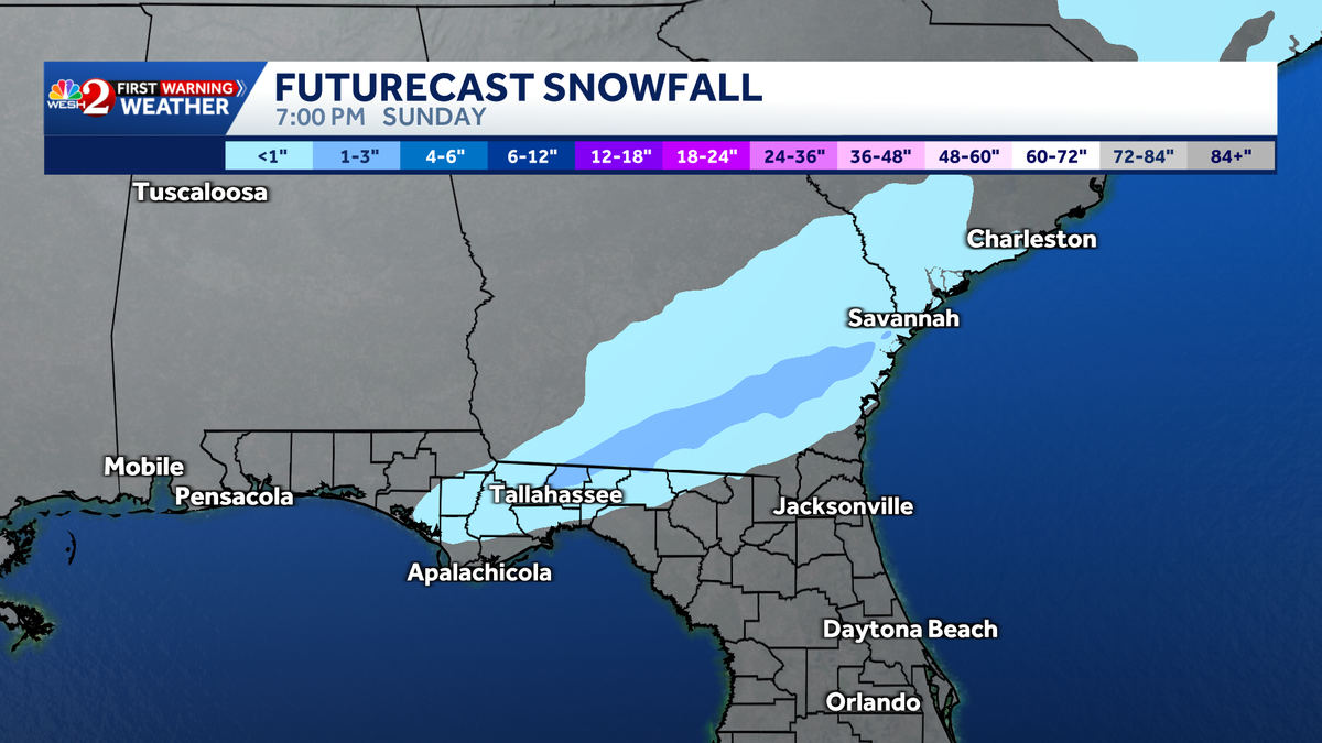
Snow enthusiasts hoping to see flurries in Florida may get their opportunity on Sunday.
Another surge of frigid air is expected to plunge southward, which will keep Florida temperatures well below normal, providing a brief window for snowfall in parts of North Florida and Georgia.
Early model data suggests snow amounts could range from a small dusting to 3 inches in the affected areas.
![]()
When was the largest snowfall in Florida
The last time the state of Florida saw snowfall was in Jan 2025. A whopping 8 to 10 inches of snow fell across Northern Florida, breaking the state’s 1954 record of 4 inches.

First Warning Weather
Stay with WESH 2 online and on-air for the most accurate Central Florida weather forecast.
Download the WESH 2 News app to get the most up-to-date weather alerts.
The First Warning Weather team includes First Warning Chief Meteorologist Tony Mainolfi, Eric Burris, Marquise Meda and Cam Tran.
What is Impact Weather?
Impact Weather suggests weather conditions could be disruptive or a nuisance for travel and day-to-day activities.