
Central Florida residents are waking up to a chilly Friday morning as temperatures plunge to their lowest levels in years.Freeze warnings and cold weather advisories remain in effect through 9 a.m. That is why WESH 2’s First Warning Weather crew has declared a severe weather warning for Friday.Residents are advised to protect plants, pipes, pets and people.Sunshine dominates today with high pressure in control, keeping conditions dry and cool, with afternoon highs only reaching the upper 50s to mid-60s and light winds. The night will be clear and cold again, with lows in the 30s and 40s, and a small chance for patchy frost in northern communities.Timing out the coldIn Orlando: Friday: Sunny, with a high near 57.Friday Night: Clear, with a low around 38. Saturday: Sunny, with a high near the 60s. >> Subscribe to the WESH 2 YouTube channelIn Cocoa Beach: Friday: Sunny, with a high near 59. Friday Night: Mostly clear, with a low around 47. Saturday: Sunny, with a high near 67.Looking aheadSaturday warms up into the upper sixties with mostly dry weather, but don’t expect to be dry all weekend. Sunday brings the next cold front, increasing rain chances to about 40%. No storms are expected, but behind the front, gusty northwest winds and colder air return Sunday night into early next week, bringing overnight lows back into the 30s on Monday.First Warning Weather Stay with WESH 2 online and on-air for the most accurate Central Florida weather forecast.RadarSevere Weather AlertsDownload the WESH 2 News app to get the most up-to-date weather alerts. The First Warning Weather team includes First Warning Chief Meteorologist Tony Mainolfi, Eric Burris, Marquise Meda and Cam Tran. What is Impact Weather?Impact Weather suggests weather conditions could be disruptive or a nuisance for travel and day-to-day activities.What is a Severe Weather Warning Day?A Severe Weather Warning Day suggests weather conditions that could potentially harm life or property.
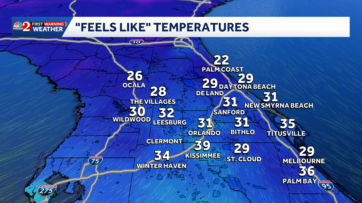
Central Florida residents are waking up to a chilly Friday morning as temperatures plunge to their lowest levels in years.
Freeze warnings and cold weather advisories remain in effect through 9 a.m. That is why WESH 2’s First Warning Weather crew has declared a severe weather warning for Friday.
Residents are advised to protect plants, pipes, pets and people.
Sunshine dominates today with high pressure in control, keeping conditions dry and cool, with afternoon highs only reaching the upper 50s to mid-60s and light winds.
The night will be clear and cold again, with lows in the 30s and 40s, and a small chance for patchy frost in northern communities.
Timing out the cold
In Orlando:
Friday: Sunny, with a high near 57.
Friday Night: Clear, with a low around 38.
Saturday: Sunny, with a high near the 60s.

>> Subscribe to the WESH 2 YouTube channel
In Cocoa Beach:
Friday: Sunny, with a high near 59.
Friday Night: Mostly clear, with a low around 47.
Saturday: Sunny, with a high near 67.

Looking ahead
Saturday warms up into the upper sixties with mostly dry weather, but don’t expect to be dry all weekend.
Sunday brings the next cold front, increasing rain chances to about 40%. No storms are expected, but behind the front, gusty northwest winds and colder air return Sunday night into early next week, bringing overnight lows back into the 30s on Monday.
First Warning Weather
Stay with WESH 2 online and on-air for the most accurate Central Florida weather forecast.
Download the WESH 2 News app to get the most up-to-date weather alerts.
The First Warning Weather team includes First Warning Chief Meteorologist Tony Mainolfi, Eric Burris, Marquise Meda and Cam Tran.
What is Impact Weather?
Impact Weather suggests weather conditions could be disruptive or a nuisance for travel and day-to-day activities.
What is a Severe Weather Warning Day?
A Severe Weather Warning Day suggests weather conditions that could potentially harm life or property.