
Snow in Florida and another cold blast on the way | What to expect
THANK YOU. ALL RIGHT, TONY, WE ALSO NEED TO FOLLOW THE WEATHER THIS WEEKEND BECAUSE LOCALLY WE’RE ACTUALLY GETTING WINTER AGAIN. YEAH. ROUND TWO. YOU GUYS READY? YEAH. NO, BUT IT’S GOING TO HAPPEN REGARDLESS. HERE WE GO. WELL DONE. ALL RIGHT, LET ME TAKE YOU BACK OUTSIDE TOMORROW. BRIEFLY WARMER. AND THEN WE’LL DO IT ALL OVER AGAIN ON SUNDAY. MORE COLD AIR, MORE RAIN AND THE POTENTIAL FOR SOME SNOW IN NORTH FLORIDA. COLD ENOUGH TONIGHT THAT WE BELIEVE THAT THERE IS GOING TO BE SOME MORE FROST HERE UP TOWARDS LAKE COUNTY, MARION COUNTY, WHERE THEY’RE UNDER A FROST ADVISORY PORTIONS THERE OF SUMTER COUNTY INLAND, FLAGLER AND VOLUSIA COUNTY WILL LIKELY ALSO SEE SOME FROST. LET ME TAKE YOU OUTSIDE RIGHT NOW, OVER TOWARDS LAKE DOOR TEMPERATURE THERE IN THE 40S. 46 OCALA 47. IN DELAND, 52 RIGHT NOW IN ORLANDO, WE TAKE A LOOK AT THAT 12 HOUR PLANNER. 52, 48, 44 AND 45 COLD HERE, NO FROST, PLENTY OF FROST. LOOK AT THE BLUE ZONE. DUNNELLON BELLEVIEW LIN OUT OVER TOWARDS SALT SPRINGS. THIS IS OUR HIGH RESOLUTION MODEL THAT WE USE NOT ONLY FOR THE TEMPERATURES, BUT THE CALCULATION OF THE FROST. YOU CAN SEE BUSHNELL BACK TOWARDS EUSTIS, MOUNT DORA, POTENTIALLY SOME FROST OVER TOWARDS PAISLEY ASTOR, JUST TO MENTION A FEW MORE CITIES THAT COULD BE IMPACTED BY THE FROST FARTHER TO THE SOUTH. WE’RE GOING TO BE OKAY. CELEBRATION. THE LAND ON THE KINGSVILLE AREA 4243 OVER TOWARDS THE COAST, RANGING FROM 43 TO 49 ON THE SAND FROM COCOA BACK TOWARDS BITHLO 4245 APOPKA, ZELLWOOD I WOULDN’T RULE OUT ZELLWOOD EUSTIS, MOUNT DORA, SORRENTO AND MOUNT PLYMOUTH. A LITTLE BIT OF PATCHY FROST. WE’LL WATCH THAT. THERE’S THE LAND, THERE’S THE WESTERN SIDE OF PALM COAST, LIKELY TO SEE SOME FROST. NOW I WANT TO TAKE YOU IN TIME AND SHOW YOU WHAT’S GOING TO HAPPEN ONCE WE GET PAST THE MORNING. LOOK AT THDS TURNING AROUND OUT OF THE SOUTH. NOW ON SATURDAY, AND YOU CAN SEE BY THE EVENING CLOUDY SKIES BEGINNING TO MARCH ON IN, FOLLOWED BY SOME RAIN BY DAYBREAK. SUNDAY MORNING. VILLAGES. WILDWOOD OVER TOWARDS OCALA. LOOK AT THESE WIND GUSTS NOW 15 TO 20 WINDS ARE OUT OF THE SOUTHWEST AND THEN TURNING TO THE NORTHWEST ON THE NORTHERN SIDE. SEE THAT LITTLE WHITE ZONE UP HERE? THAT IS A LITTLE PERIOD OF POTENTIAL SNOW AS THIS FRONT CONTINUES TO POUR SOUTH, THINGS WILL BEGIN TO CLEAR ON OUT. AS WE GET YOU INTO EARLY TO MID AFTERNOON ON SUNDAY, SETTING THE STAGE FOR WHAT IS GOING TO BE A VERY, VERY COLD MONDAY MORNING RAINFALL AMOUNTS WITH THAT FRONT, A QUARTER TO A HALF AN INCH IN MARION COUNTY, MOST FOLKS WILL SEE LESS THAN A QUARTER OF AN INCH OF RAIN. SO IF YOU’RE TIRED OF THE COLD, TOMORROW IS GOING TO BE YOUR DAY. LOOK AT THESE AFTERNOON HIGHS RUNNING IN THE LOW 70S. THE I-4 CORRIDOR 7273 DEGREES, A LITTLE COOLER. PALM COAST DOWN TOWARDS NEW SMYRNA BEACH. AND THEN AS WE TAKE YOU TO THE ATTRACTIONS TOMORROW, COOL START, BEAUTIFUL AFTERNOON. GET OVER THERE, HAVE SOME FUN IN THE SUN. AND THEN MONDAY, TUESDAY AND WEDNESDAY, 2831 33 OCALA. THAT’S ANOTHER COLD STRETCH OF WEATHER BEHIND THIS FRONT RIGHT HERE. THAT’S GOING TO BE DROPPING SOUTH WITH A LITTLE BIT OF SNOW ON THE NORTHERN SIDE, POTENTIALLY INTO NORTH FLORIDA AND SOUTHEAST GEORGIA. WHEN YOU TAKE A LOOK AT THE SNOWFALL POTENTIAL MAPS HERE, HERE’S WHERE WE’RE LOOKING AT TALLAHASSEE. BACK TOWARDS SAVANNAH. YOU’RE GOING ABOUT AN INCH TO 1 TO 3IN OF RAIN ACROSS GEORGIA. THE AMERICAN MODEL IS GOING WITH A LITTLE BIT MORE SWATH OF 1 TO 3 ACROSS SOUTH GEORGIA. THE SOUTHERN EXTENT NEAR TALLAHASSEE, AND OUR LOCAL HIGH RES MODEL DOES HAVE A LITTLE BIT OF SNOW NORTH OF TALLAHASSEE BUILDING TOWARDS SAVANNAH. BY THE TIME WE GET YOU INTO LATE SUNDAY MORNING ON INTO THE AFTERNOON, PUTTING IT ALL TOGETHER HERE FOR YOU NOW. IMPACT WEATHER FOR MONDAY MORNING DUE TO THE COLD AND THEN ANOTHER
Snow in Florida and another cold blast on the way | What to expect

Updated: 8:03 PM EST Jan 16, 2026
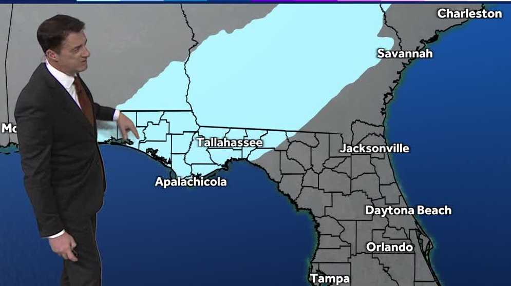
Another strong cold front will bring snow up along the Florida-Georgia line. Residents and travelers in the Tallahassee area could start to see snowflakes as early as dawn on Sunday.North Florida and Georgia could see anywhere from a trace to 3 inches of snow if our current models don’t change. The last time we had measurable snowfall in Central Florida you have to go back to Dec. 1989 when snow fell along the I-4 corridor. While snow isn’t in the forecast for Central Florida this year, another blast of cold winter air is expected to flow through late Sunday, early Monday. When was the last snowfall in Florida?This isn’t the first time Florida has seen snow flurries. There have been more than 80 instances of snowfall in Florida documented since 1886. The last time it snowed in Florida was around this same time last year, in Jan 2025 when 8 to 10 inches of snow fell across Northern Florida, breaking the state’s 1954 record of 4 inches. First Warning Weather Stay with WESH 2 online and on-air for the most accurate Central Florida weather forecast.RadarSevere Weather AlertsDownload the WESH 2 News app to get the most up-to-date weather alerts. The First Warning Weather team includes First Warning Chief Meteorologist Tony Mainolfi, Eric Burris, Marquise Meda and Cam Tran.What is Impact Weather?Impact Weather suggests weather conditions could be disruptive or a nuisance for travel and day-to-day activities.
Another strong cold front will bring snow up along the Florida-Georgia line. Residents and travelers in the Tallahassee area could start to see snowflakes as early as dawn on Sunday.
North Florida and Georgia could see anywhere from a trace to 3 inches of snow if our current models don’t change.
The last time we had measurable snowfall in Central Florida you have to go back to Dec. 1989 when snow fell along the I-4 corridor.

While snow isn’t in the forecast for Central Florida this year, another blast of cold winter air is expected to flow through late Sunday, early Monday.
When was the last snowfall in Florida?
This isn’t the first time Florida has seen snow flurries. There have been more than 80 instances of snowfall in Florida documented since 1886.
The last time it snowed in Florida was around this same time last year, in Jan 2025 when 8 to 10 inches of snow fell across Northern Florida, breaking the state’s 1954 record of 4 inches.

First Warning Weather
Stay with WESH 2 online and on-air for the most accurate Central Florida weather forecast.
Download the WESH 2 News app to get the most up-to-date weather alerts.
The First Warning Weather team includes First Warning Chief Meteorologist Tony Mainolfi, Eric Burris, Marquise Meda and Cam Tran.
What is Impact Weather?
Impact Weather suggests weather conditions could be disruptive or a nuisance for travel and day-to-day activities.