
Snow in Florida and ANOTHER Cold Blast on the Way | What to Expect And Where – January 17th Forecast
Snow in Florida and ANOTHER Cold Blast on the Way | What to Expect And Where – January 17th Forecast
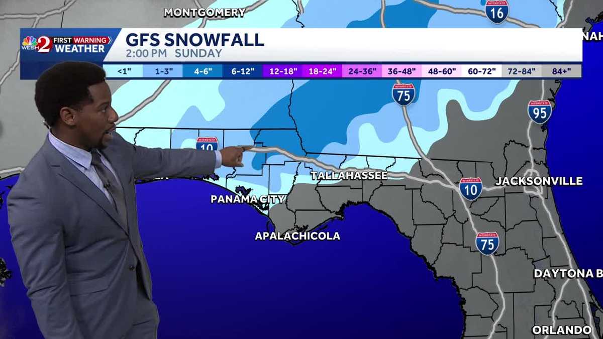
JENN SULLIVAN, WESH TWO NEWS. ALL RIGHT, LET’S TALK ABOUT WHAT IS GOING ON WEATHER WISE. SOME MILD TEMPERATURES OUT THERE, TO PUT IT NICELY. MUCH BETTER THAN THOSE FREEZING TEMPERATURES THAT WE HAVE BEEN EXPERIENCING. IT’S LIKE WE’RE UP. WE’RE DOWN. THE ROLLER COASTER RIDE ALWAYS CONTINUES HERE IN CENTRAL CENTRAL FLORIDA. YES, IT’S IT’S CRAZY BECAUSE WE WERE BACK IN THE 30S TO START THE 30S AND 40S FRIDAY MORNING THIS AFTERNOON. YEAH. IT’S NICE TO SEE. RIGHT. TAKE A LOOK AT THE DIFFERENCE THAT 12 HOURS, 24 HOURS CAN MAKE EVERYWHERE IN CENTRAL FLORIDA. YOU ARE SIGNIFICANTLY WARMER THAN YOU WERE AT THIS POINT IN TIME YESTERDAY. SOME OF US THAT DIFFERENCE COULD BE CLOSE TO 20 DEGREES, LIKE WILDWOOD, A 17 DEGREE DIFFERENCE, JUST LIKE DAYTONA BEACH AS WELL. BUT DON’T GET TOO COMFORTABLE. MAJOR CHANGES ARE ON THE WAY, SO I HOPE YOU’RE ABLE TO SOAK UP THE SUNSHINE TODAY AND THE HEAT BECAUSE BOTH WILL BE GONE BY TOMORROW. HERE’S A LOOK AT DAYTONA BEACH CURRENTLY, IN WHICH WE DO SHOW TEMPERATURES IN THE MID AND UPPER 60S. SOME OF US STILL HANGING AROUND THE 70S, LIKE KISSIMMEE AND SAINT CLOUD, BUT WE’LL BE COOLING OFF TONIGHT, DROPPING DOWN TO THE 50S BEFORE YOUR NIGHT IS SAID AND DONE. BUT TOMORROW WE WILL SEE THE CHANCE FOR SHOWERS AND BREEZY WEATHER THROUGHOUT THE AFTERNOON. AND THEN ON MONDAY, IT’S ANOTHER POLAR PLUNGE HERE IN CENTRAL FLORIDA. A FRIGID START TO YOUR MORNING. AND THEN WE’RE STILL CHILLY IN THE AFTERNOON, WITH HIGHS NOT GOING TO BE ABLE TO MAKE IT OUT OF THE 50S. SO FOR TONIGHT, CLOUDS ARE RETURNING INTO THE PICTURE. WE’LL SEE THOSE TEMPERATURES STALL IN THE MID 50S. IF YOU’RE IN THE ORLANDO AREA. NOW WE ALSO SEE THAT CHANCE FOR RAIN STARTING TO INCREASE AS EARLY AS 5:00 AT 20% COVERAGE. YOU WON’T SEE THE SHOWERS QUITE THIS EARLY IN THE METRO, BUT YOU WILL SEE THEM FOR OUR NORTH AND WESTERNMOST COMMUNITIES. AND IT’S COURTESY OF THIS COLD FRONT. YOU SEE THAT ACROSS THE PANHANDLE RIGHT NOW, AND THE SHOWERS MOVING IN FROM THE GULF COMING FROM THE SOUTH AND THE WEST, SURROUNDING THAT FRONTAL BOUNDARY, SHOWERS WILL TURN TO SNOW FOR SOME OF OUR NORTHERNMOST COUNTIES ACROSS THE STATE. BUT BY MONDAY, HERE’S WHAT YOU’RE GOING TO BE STEPPING OUTDOORS TO. TEMPERATURES THAT PLUMMET ALL THE WAY DOWN INTO THE MIDDLE OF THE 30S, A 39 DEGREE DROP FROM THE HIGHS THAT WE DID EXPERIENCE TODAY. SO, AS I MENTIONED, MAJOR CHANGES ARE INBOUND HERE IN CENTRAL FLORIDA. AND WITH THAT, MUCH OF A TEMPERATURE DROP, WE HAVE A TIGHT TEMPERATURE GRADIENT SURROUNDING THAT FRONTAL BOUNDARY. WHAT THAT MEANS WE’LL HAVE SOME VERY STRONG WINDS. THE HIGHER THE TEMPERATURE DIFFERENCE, THE STRONGER THE WINDS TYPICALLY ARE SURROUNDING A COLD FRONT. SO ONCE IT STARTS TO MOVE IN FROM THE NORTH AND THE WEST, NOTICE WITH THE RAIN SHOWERS YOUR WINDS ARE INCREASING, RIGHT? WILDWOOD 29MPH. OCALA 29MPH. THIS IS VERY EARLY ON SUNDAY MORNING IN WHICH WE’RE GUSTING NEARLY 30MPH CONDITIONS, AND WE WILL SEE THOSE GUSTS EXCEED 30MPH AS WE DRAW CLOSER TO THE AFTERNOON. ALSO, YOUR RAIN COVERAGE STARTS TO BECOME A LITTLE BIT MORE WIDESPREAD. A 50% COVERAGE THROUGHOUT THE DAY. MOST OF THE SHOWERS WILL BE NORTH OF I-4. THAT’S WHERE WE HAVE THE HEAVIEST CONCENTRATION OF RAIN, BUT WE CAN STILL SEE SOME TOWARDS OUR COASTAL COMMUNITIES AS WELL. BUT LATER IN THE DAY, WE’RE STILL BREEZY IN THE AFTERNOON. NOTICE HOW WE CLEAR OUT JUST AS SOON AS THE FRONT PASSES BY. BUT THE WINDS, THEY REALLY STICK AROUND HEADING INTO MONDAY MORNING. AS FAR AS RAIN SHOWERS ARE CONCERNED, ACCUMULATIONS ARE GOING TO BE A LITTLE BIT GREATER ONCE YOU HEAD NORTH ACROSS. I-75 COULD SEE UP TO HALF AN INCH, MAYBE A FULL INCH IN PLACES LIKE THE VILLAGES AND OCALA. BUT SPEAKING OF INCHES, WE COULD HAVE INCHES OF RAIN ACROSS THE PANHANDLE NEXT TO I-10. WE COULD POSSIBLY SEE FOUR TO POSSIBLY EVEN SIX INCHES. NOW, THIS IS ONE OF THE MODELS THAT’S A LITTLE BIT HEAVIER ON THE SNOWFALL ACCUMULATION IN BETWEEN THE TWO THAT WE WERE JUST TALKING ABOUT, WE COULD POSSIBLY SEE MAYBE ABOUT AN INCH TO THREE INCHES IN SOME ISOLATED AREAS. BUT FOR US IN CENTRAL FLORIDA, IT’S ANOTHER COLD BLAST AS WE DROP DOWN TO THE 20S IN OCALA, MID 30S FOR US INSIDE THE METRO ALONG THE I-4 CORRIDOR. WE’RE ALSO WATCHING OUT FOR A FREEZE WATCH ON MONDAY MORNING WITH A BETTER CHANCE OF COOLER TEMPERATURES. CERTAINLY NORTH, BUT ALL ACROSS CENTRAL FLORIDA WE RUN THE RISK OF FROST. TO START OFF YOUR MONDAY, AND THEN AS WE GET FURTHER IN TIME THROUGHOUT THE WORKWEEK, EVENTUALLY WE DO THAW OUT. HIGH PRESSURE SETTLES IN AFTER A WEAK FRONTAL BOUNDARY PASSES US BY. AND WE’RE BACK IN THE 70S BEFORE YOU KNOW IT. SO WE DO HAVE SOME THINGS TO LOOK FORWARD TO, BUT I’M DEFINITELY NOT LOOKING FORWARD TO MONDAY MORNING AS TEMPERAT
Snow in Florida and ANOTHER Cold Blast on the Way | What to Expect And Where – January 17th Forecast
Snow in Florida and ANOTHER Cold Blast on the Way | What to Expect And Where – January 17th Forecast

Updated: 6:59 PM EST Jan 17, 2026
Snow in Florida and ANOTHER Cold Blast on the Way | What to Expect – January 17th ForecastA cold front is pushing toward Central Florida tonight, with clouds increasing this evening and overnight. It stays mostly dry, but a few showers could reach Sumter and Marion counties near sunrise. Overnight lows stay mild in the 50s. Throughout the day Sunday, that front moves through with scattered showers, mainly north and west of I-4. No storms expected, but it will turn very windy with the rain. Further North along the Panhandle a dusting of snow is possible (< 1inch) Sunday morning. Back here at home, winds shift northwest throughout the day with gusts of 25 to 35 mph. Much colder air rushes in Sunday afternoon. Temperatures fall through the day, and by Monday morning we’re looking at lows in the low to mid-30s with a Freeze Watch in effect. Wind chills dip into the 20s, and Monday stays sunny but cold, with highs struggling to reach the 50s and low 60s.
Snow in Florida and ANOTHER Cold Blast on the Way | What to Expect – January 17th Forecast
A cold front is pushing toward Central Florida tonight, with clouds increasing this evening and overnight. It stays mostly dry, but a few showers could reach Sumter and Marion counties near sunrise. Overnight lows stay mild in the 50s. Throughout the day Sunday, that front moves through with scattered showers, mainly north and west of I-4. No storms expected, but it will turn very windy with the rain. Further North along the Panhandle a dusting of snow is possible (< 1inch) Sunday morning. Back here at home, winds shift northwest throughout the day with gusts of 25 to 35 mph. Much colder air rushes in Sunday afternoon. Temperatures fall through the day, and by Monday morning we’re looking at lows in the low to mid-30s with a Freeze Watch in effect. Wind chills dip into the 20s, and Monday stays sunny but cold, with highs struggling to reach the 50s and low 60s.