
TALLAHASSEE, Fla. (WCTV) – A winter weather system will bring mostly cold rain to Big Bend and South Georgia Sunday morning, with some snow mixing in at times as a cold front moves through the region.
Cold rain, wintry mix to kick off our Sunday morning
Mostly wet with occasional snow flurries and light accumulations possible on grassy surfaces.
What to expect this morning:
The winter weather event began during the pre-dawn hours Sunday, with rain transitioning to a rain and snow mix across the region as a strong cold front pushes through. Expect mostly cold rain with occasional snow mixing in throughout the morning.
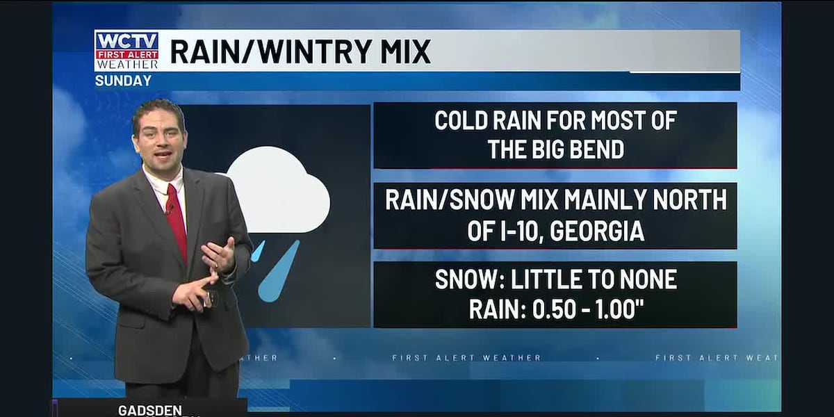
Mostly cold rain with occasional snow flurries and light accumulations possible on grassy surfaces. Forecast snowfall amounts will be 1 inch or less. Rain totals between 0.50″ and 1.00.
While the heaviest snow is expected to develop along an axis from near Dothan northeast to near Dawson and Leesburg, Georgia, Big Bend and South Georgia will experience primarily rain with some snow mixing in. Light accumulations will mainly be confined to grassy surfaces, with most roads remaining wet rather than snow-covered.
Travel impacts:
Residents in Big Bend and South Georgia should use caution on roadways this morning, but conditions should remain manageable. Expect wet roads and reduced visibility during heavier rain and snow mix periods, but significant snow accumulation is not expected.
Most of the day will feature cold rain, so plan for typical wet weather rather than winter weather driving conditions.
When will it end?
Precipitation will come to an end around midday Sunday as drier air exits the region. A cold and sunny end to the day, with temperatures in the 40s and wind chills in the 30s.
Winds and marine hazards:
Behind the strong cold front, hazardous marine conditions are expected on Sunday. A Gale Warning is in effect through early afternoon for Gulf waters, with northerly winds gusting near 40 knots this morning—still rough waters in the afternoon.
Inland, winds out of the north/northwest will blow between 15 and 25 mph.
What comes next:
Following the system, widespread freezing temperatures are forecast for late Sunday night and Monday morning, with lows in the mid-to-upper 20s across Big Bend and South Georgia. A cold and dry air mass will persist through Tuesday night. Highs in the 50s and low 60s.
Low-impact weather is expected from Monday through Saturday, with only a slight chance of a few showers around Thursday as a weak cold front moves through the area.
To stay updated on all the latest forecasts and weather, follow WCTV First Alert Weather on Facebook and X (Twitter).
Click here to see all the latest weather headlines and here to view the First Alert Radar. Receive push alerts and watch the latest forecast anytime on the free WCTV First Alert Weather app. Click here to download it now.
Interested in becoming a WCTV First Alert Weather Watcher? Click here to join the team!
Copyright 2026 WCTV. All rights reserved.