
Snow in the Panhandle | All Four Seasons Across Florida – Summer to Winter And Everything in Between
Snow in the Panhandle | A Taste of All Four Seasons Across Florida – Summer to Winter and Everything in Between
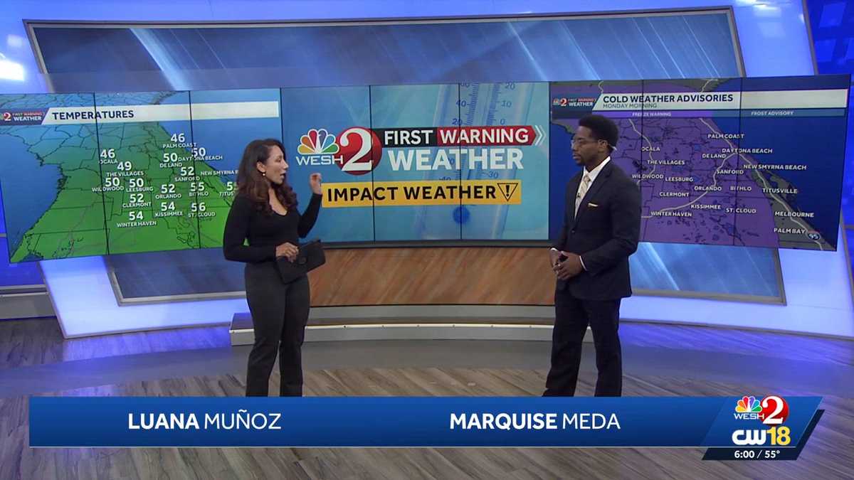
BUT FIRST, WE’RE TALKING ALL THINGS WEATHER. GOOD EVENING AND THANKS FOR JOINING US. I’M LUANA MUNOZ JOIN WITH MARQUISE MEDA RIGHT NOW. MARQUISE OUR HIGH TODAY 79 DEGREES. THEN IT DROPPED DOWN INTO THE 50S. THIS IS WACKY WEATHER. IT’S SO CRAZY. WE’RE GOING TO HAVE A TASTE OF FOUR DIFFERENT SEASONS HERE ACROSS THE SUNSHINE STATE. OUR FRIENDS UP NORTH, THEY HAD THAT TASTE OF WINTER TODAY WITH THE COLD FRONT MOVING IN WITH A CHANCE FOR SOME SNOW ACROSS THE PANHANDLE HERE IN CENTRAL FLORIDA. YOUR HIGH IN ORLANDO AS YOU ALLUDED TO. LUANA WE WERE BACK IN THE UPPER 70S. WE HAD SOME STRONG GUSTY WINDS COURTESY OF THIS COLD FRONT MOVING ACROSS THE I-4 CORRIDOR. WINDS GUSTING UPWARDS OF 50MPH TODAY. AND THEN ON TOP OF THAT, WE’LL GET THAT TASTE OF WINTER HERE IN CENTRAL FLORIDA. AFTER THE RAIN SHOWERS THAT WE SAW TODAY AS WELL. SO HERE’S A LOOK AT YOUR HIGHS. LOOK AT THE TEMPERATURE DISPARITY UP IN OCALA WHERE YOU GUYS WERE HIT BY THE COLD FRONT. FIRST YOU ONLY REACHED 58 DEGREES. BUT HERE IN ORLANDO, BITHLO KISSIMMEE, YOU GUYS WERE IN THE UPPER 70S JUST EAST OF THE I-4 CORRIDOR. AND ONCE YOU MADE YOUR WAY TOWARDS I-95, WE SAID HELLO TO THE 80S THIS AFTERNOON. OF COURSE, NONE OF US ARE NOW IN THE 80S WITH THAT COLD FRONT MOVING ACROSS THE REGION AND WHAT IT LEFT BEHIND IN ITS PATH. STRONG, BREEZY, GUSTY WINDS SURGING ABOVE 50MPH IN WINTER HAVEN. ORLANDO. ALSO SANFORD, 55 MILE PER HOUR GUSTS. AND THOSE CERTAINLY CHANGE YOUR TEMPERATURES AS THE GUSTS STARTED TO FLOW, YOUR TEMPERATURES BEGIN TO DROP. WE ACTUALLY FELL FROM YOUR HIGH OF 79 DOWN INTO THE 50S IN JUST UNDER AN HOUR HERE IN CENTRAL FLORIDA TODAY. SO RIGHT NOW WHERE WE SIT 52 DEGREES WITH THE WIND FROM THE NORTH AND THE WEST AT 13MPH, THAT NORTHERLY COMPONENT WILL CERTAINLY COOL TEMPERATURES DOWN. AS WE TAKE A LOOK AT SATELLITE AND RADAR. NO MORE RAIN IN THE PICTURE, JUST A FEW EXTRA CLOUDS, BUT UP NORTH. TAKE A LOOK AT THE SNOWFALL THAT WE DID RECEIVE OUT TOWARDS MARIANNA IN JACKSON COUNTY. 1.3IN OF SNOW. SO JUST A BIT ABOVE A DUSTING. IT’S GOING TO BE A LONG TIME BEFORE WE MAY SEE SNOW AGAIN. SO PRETTY HISTORIC HERE IN CENTRAL FLORIDA. LUANA. IT IS SO HARD FOR ME TO BELIEVE. LOOK AT THESE IMAGES RIGHT HERE. A LOT OF PEOPLE OUT THERE HAVING A GOOD TIME. HARD TO BELIEVE THIS IS FLORIDA. THAT SNOW CREATING A GLIMMER OF A WINTER WONDERLAND IN PARTS OF THE PANHANDLE TODAY. WESH TWO’S JESSE PAGAN WENT CHASING THE FRESH POWDER, AS I LIKE TO CALL IT, WHERE MOTHER NATURE ULTIMATELY DELIVERED. I’M ONE OF THOSE, JUST THAT, ONE THING. IT’S ANOTHER BUSY SUNDAY AT BIG JOHN’S BARBECUE AND DONUTS IN BONIFAY FROM SOUR CREAM CAKE. BLUEBERRY CAKE. WE’VE HAD RED VELVET WITH CREAM CHEESE, BUT THE CONVERSATION IS LESS ABOUT THE FROSTED DONUTS AND MORE ABOUT THE FROSTED TOWN THEY’VE BEEN POURING IN. AND YEAH, THAT’S ALL THEY TALK ABOUT IS HOW BIG THE FLAKES WERE AND HOW WE GOT IT. WOKE UP THIS MORNING, WALKED OUTSIDE AND IT WAS SNOWING. JONATHAN KIRKLAND IS A BIG JOHN’S REGULAR AND AT BREAKFAST THIS MORNING, SNOW IS ALL HE AND JASON COULD TALK ABOUT AS A FLORIDA MAN. IT’S WILD. I’M STILL NOT USED TO IT. FOR DAYS, THE FORECASTERS EXPECTED SNOW IN THIS AREA OF THE PANHANDLE WEST OF TALLAHASSEE OVERNIGHT INTO SUNDAY. THE NATIONAL WEATHER SERVICE UPGRADED THEIR ADVISORIES TO A WINTER STORM WARNING. EARLY MORNING RAIN IN MARIANNA TURNED INTO SLEET, AND A LITTLE LATER, AT A FEW MILES WEST. IT CAME DOWN. IT MAY NOT BE MUCH, BUT TO US FLORIDIANS, IT’S SNOW NONETHELESS, JUST ENOUGH FOR IT TO COVER CARS LIKE THIS THAT AREN’T MOVING SOME BUSHES AND SOME ROOFS. OUT HERE IN CHIPLEY. WE DIDN’T THINK WE WAS GOING TO GET ANYTHING. AND THEN ABOUT 630 IT STARTED FLURRYING. AND THEN THE NEXT THING YOU KNOW, THEY WERE HUGE. THEY, YOU KNOW, THEY JUST LOOK LIKE SOFTBALLS COMING DOWN, JUST FLAT, JUST BIG AS BIGGEST FLAKES I’VE EVER SEEN. AND FOR FOLKS IN THE PANHANDLE, THAT’S ENOUGH TO GET A LITTLE WINTER MAGIC FLOATING IN THE AIR. EVEN IF THEY’RE FLORIDIANS THROUGH AND THROUGH, READY FOR IT TO WARM UP BY THIS POINT IN THE MORNING, THE SUN IS OUT, AND MOST OF WHAT FELL IS MELTED. THAT DOESN’T MEAN IT WASN’T A NICE TREAT FOR THE PEOPLE OF THE PANHANDL
Snow in the Panhandle | All Four Seasons Across Florida – Summer to Winter And Everything in Between
Snow in the Panhandle | A Taste of All Four Seasons Across Florida – Summer to Winter and Everything in Between

Updated: 6:59 PM EST Jan 18, 2026
A Taste of All Four Seasons in the Sunshine State, Including Snow Along the Panhandle | January 18th 2026Rain showers (and snow for Northern Florida) were present this morning as a strong cold front is sweeping south across central Florida today, bringing damaging winds and a sharp temperature drop. Wind gusts as high as 52 miles per hour (Orlando) were recorded as the front moved through, with breezy conditions continuing into this evening.Behind the front, temperatures are falling fast. Some areas dropped from the 70s into the 50s in under an hour. And that drop will follow us into the evening tonight. Freeze Warnings and Cold Weather Advisories (Through 9:00 AM) are in effect late tonight into early Monday, with lows in the 30s and wind chills in the 20s by morning.Cold weather lingers through early week, with highs mainly in the 50s Monday and another chilly start Tuesday. Conditions stay dry through midweek, then scattered showers may return Thursday and Friday, followed by a warmer trend heading into the weekend
A Taste of All Four Seasons in the Sunshine State, Including Snow Along the Panhandle | January 18th 2026
Rain showers (and snow for Northern Florida) were present this morning as a strong cold front is sweeping south across central Florida today, bringing damaging winds and a sharp temperature drop. Wind gusts as high as 52 miles per hour (Orlando) were recorded as the front moved through, with breezy conditions continuing into this evening.Behind the front, temperatures are falling fast. Some areas dropped from the 70s into the 50s in under an hour. And that drop will follow us into the evening tonight. Freeze Warnings and Cold Weather Advisories (Through 9:00 AM) are in effect late tonight into early Monday, with lows in the 30s and wind chills in the 20s by morning.Cold weather lingers through early week, with highs mainly in the 50s Monday and another chilly start Tuesday. Conditions stay dry through midweek, then scattered showers may return Thursday and Friday, followed by a warmer trend heading into the weekend