
Central Florida wind chills drop to 20s, 30s this morning; warmer weather on the way
NONETHELESS. THIS HAS NEVER HAPPENED BEFORE. OKAY. LET’S TALK A LITTLE BIT ABOUT THIS MORNING. IT’S CHILLY. IT’S HAPPENED BEFORE. THAT HAS HAPPENED BEFORE LIKE YESTERDAY. STOP HAPPENING. WE’VE GOT A LITTLE BIT OF A BREEZE. SO THE WIND CHILLS ARE A THING, BUT WE’RE ALREADY LOOKING AHEAD TO SOME NICE CHANGES. SO FIRST OFF, BACK TO WORK AND BACK TO SCHOOL. MORNING BUS STOP IS GOING TO BE COLD IMPACT. WHETHER YOU WANT TO HAVE THE JACKET HANDY. OKAY THEN INTO THE AFTERNOON MILDER. I MEAN I DON’T KNOW THAT I’D SAY 65 WAS MILD BUT MILDER TEMPERATURES. WE’RE GETTING BETTER AND BETTER. BUT LOOK AT HOW MICROCLIMATES PLAY OUT IN VOLUSIA COUNTY, FOR EXAMPLE. WE’RE IN THE 40S FROM PONCE INLET OVER TO BEACH SAFETY AND DAYTONA BEACH. LOOK AT SAMUEL AT 31. LOOK AT DELAND, DOWNTOWN DELAND AT 29 DEGREES. IT’S 29. IN DELEON SPRINGS, 28 IN ASTOR. YOU GET INLAND AND OH, DOES THAT TEMPERATURE DROP LIKE A ROCK? 50 DEGREES AT PATRICK, 49, PORT CANAVERAL, 40. PORT SAINT JOHN 39. HERE IN MIMS, SEMINOLE COUNTY. IT’S 39 IN GENEVA, 33 IN CASSELBERRY, 32 DEGREES ALTAMONTE SPRINGS AND INTO ORANGE COUNTY, SITTING AT 41 UCF, 44 ON I-DRIVE AND 41 IN WINDERMERE. SO IT’S A COLD START AREA WIDE. WE’VE GOT COLDER POCKETS, OF COURSE, BUT YOU GET THE IDEA. 38 IN OCALA, 33 IN WILDWOOD AND 40 DEGREES IN CLERMONT. THEN YOU WORK IN A BREEZE OF ABOUT 3 TO 8 MILES AN HOUR ON AVERAGE, AND THERE’S JUST THAT LITTLE EXTRA BITE. SO YOU WANT TO BE ABLE TO BUNDLE UP THIS MORNING. BUT WATCHING THOSE TEMPERATURES THROUGH THE DAY, THEY’LL CLIMB BEAUTIFULLY 57 BY 11:00, 62 DEGREES BY 1:00 AND 65 WILL BE OUR HIGH TEMPERATURE ON THE DAY, AT LEAST IN ORLANDO. AVERAGE HIGH 72. SO WE’RE RUNNING BELOW AVERAGE, BUT WE’RE CREEPING BACK IN THAT DIRECTION. YEAH, 62 DEGREES IN OCALA, 60 IN DAYTONA BEACH AND NEARLY 70 IN MELBOURNE. SO FOR TODAY, CHILLY START, BUT A COMFORTABLE FINISH THE REST OF THE WEEK. WE WATCH TEMPERATURES WARM. AND THEN THIS WEEKEND SHOWERS, WARM TEMPERATURES AND OUR NEXT COLD FRONT MOVING IN FRIDAY, SATURDAY, SUNDAY. LOOK AT THESE HIGHS 80 DEGREES ON FRIDAY, 81 ON SATURDAY AND 80 DEGREES ON SUNDAY. MODELS ARE SHOWING MONDAY TUESDAY. OUR NEXT FRONT WILL WORK INTO THE AREA. SO LET’S PUT IT ALL TOGETHER. IMPACT WEATHER THIS MORNING. BECAUSE OF THE CHILL, IT WILL BE MUCH BETTER THIS AFTERNOON AT 6570 FOR OUR WEDNESDAY, THURSDAY, FRIDAY A FEW SPRINKLES. WE HIT 80 DEGREES THIS WEEKEND. SHOWERS 80 AND THEN INTO MONDAY. RAIN AS THAT NEXT FRONT CLEARS THE AREA, WE’LL ADD IN A FEW ADDITIONAL SHOWERS FOR OUR COASTAL SEVEN DAY FORECAST. OTHERWISE, THINGS ARE JUST ABOUT AS NICE. THEY’RE TALKING MUCH
Central Florida wind chills drop to 20s, 30s this morning; warmer weather on the way

Updated: 5:59 AM EST Jan 20, 2026
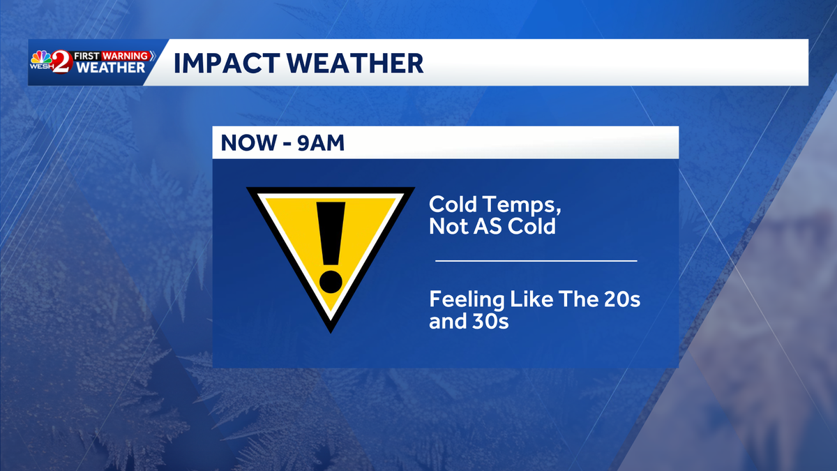
After a chilly start, with temperatures in the 20s in northwestern areas of Central Florida and the 30s and 40s elsewhere, the weather is expected to warm into the 60s today. The WESH 2 First Warning Weather team has declared Impact Weather due to Cold Weather Advisories in effect until 9 a.m.While it’s going to be a frosty start around the area, temperatures on Tuesday actually warm a touch more than Monday.On Wednesday, the warming continues with highs in the 70s, nearly reaching 80 degrees by late week. First Warning Weather Stay with WESH 2 online and on-air for the most accurate Central Florida weather forecast.RadarSevere Weather AlertsDownload the WESH 2 News app to get the most up-to-date weather alerts. The First Warning Weather team includes First Warning Chief Meteorologist Tony Mainolfi, Eric Burris, Marquise Meda and Cam Tran.What is Impact Weather?Impact Weather suggests weather conditions could be disruptive or a nuisance for travel and day-to-day activities.
ORLANDO, Fla. —
After a chilly start, with temperatures in the 20s in northwestern areas of Central Florida and the 30s and 40s elsewhere, the weather is expected to warm into the 60s today.
The WESH 2 First Warning Weather team has declared Impact Weather due to Cold Weather Advisories in effect until 9 a.m.
This content is imported from Twitter.
You may be able to find the same content in another format, or you may be able to find more information, at their web site.
While it’s going to be a frosty start around the area, temperatures on Tuesday actually warm a touch more than Monday.
On Wednesday, the warming continues with highs in the 70s, nearly reaching 80 degrees by late week.
First Warning Weather
Stay with WESH 2 online and on-air for the most accurate Central Florida weather forecast.
Download the WESH 2 News app to get the most up-to-date weather alerts.
The First Warning Weather team includes First Warning Chief Meteorologist Tony Mainolfi, Eric Burris, Marquise Meda and Cam Tran.
What is Impact Weather?
Impact Weather suggests weather conditions could be disruptive or a nuisance for travel and day-to-day activities.