
Central Florida to see warming trend before cold front hits
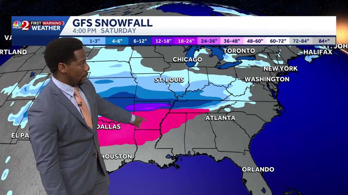
YEAH, I KNOW, BUT YES, TEMPERATURES WILL BE LIFTING OFF THIS AFTERNOON. LOOKING TO RETURN TO THE UPPER 70S IN ORLANDO. AND WE’LL CONTINUE THIS WARMING TREND ACROSS YOUR WEEKEND AS WELL. 77 FOR YOUR HIGH IN ORLANDO THIS AFTERNOON. YOU’LL MATCH THAT IN SANFORD. ALSO LEESBURG A LITTLE BIT COOLER ACROSS THE COAST 72 IN DAYTONA MELBOURNE 75. BUT ALL OF US WILL BE PEEKING ABOVE OUR SEASONAL AVERAGE. LET’S TALK ABOUT THE RIGHT HERE AND NOW ACROSS BREVARD COUNTY. HERE’S WHERE SOME OF YOUR WARMEST TEMPERATURES DO LIE. TITUSVILLE, MELBOURNE, PALM BAY ALL SHOWING 59 DEGREES HERE JUST BEFORE 520, OUR TOWER CAM NETWORK, SITUATED IN BREVARD COUNTY, DOES SHOW A LITTLE BIT OF FOG IN THE AIR, BUT ULTIMATELY THAT FOG WILL LIFT AND YOUR TEMPERATURES WILL CONTINUE TO RISE. THAT MOISTURE IS BEING BROUGHT TO YOU BY THAT EAST COAST SEA BREEZE THIS MORNING. BUT AS WE TAKE A LOOK AT YOUR TEMPERATURES DAY AFTER DAY, WE’RE GETTING WARMER AND WARMER. CLIMBING INTO THE UPPER 70S BY SATURDAY MID 80S BY SUNDAY. AND I’LL HAVE A LOOK AT THOSE RECORD SETTING POTENTIALS COMING UP IN JUST A FEW SHORT MOMENTS. BUT ACROSS THE COASTLINE, KEEP IN MIND WE STILL HAVE A RIP CURRENT RISK THAT REMAINS HIGH IN VOLUSIA AND BREVARD COUNTY, AS HIGH PRESSURE REALLY LEADS THE WAY TO DICTATE OUR FORECAST TODAY AND TOMORROW. AS WE’RE JUST BENEATH THIS COLD FRONT. SO IT’S STILL A WARM AND MOIST POCKET OF AIR WITH THAT EAST COAST SEA BREEZE COMING YOUR WAY TO FINISH OFF THE WORK WEEK. AS FAR AS YOUR NUMBERS ARE CONCERNED, IN MELBOURNE WILL BE REACHING 75 DEGREES THIS AFTERNOON. MOSTLY CLOUDY. EARLY ON. WE’LL START TO UNRAVEL THE CLOUDS LATER IN THE AFTERNOON AND THAT PROPELS YOUR HIGH TEMPERATURES TO THE UPPER 70S INLAND. SO FROM OCALA, THROUGH THE VILLAGES DOWN INTO THE METRO, 77 IS LIKELY GOING TO BE YOUR HIGH THIS AFTERNOON. AND THEN OVER THE COURSE OF THE EVENING, TEMPERATURES WILL DROP DOWN ANYWHERE BETWEEN THE LOW 50S IN THE UPPER 60S. BUT TOMORROW WE CONTINUE TO WARM UP. 71 TO 82 DEGREE TEMPERATURES WILL BE BACK. LOOKS LIKE YOU’RE A LITTLE BIT COOLER UP NORTH IN FLAGLER COUNTY, BUT INSIDE OUR INLAND MOST AREAS WE CAN SHOW THOSE HIGHS RETURNING TO THE LOWER 80S. WHAT WE’RE ALSO WATCHING OUT FOR IS THE WINTER STORM THAT WILL TRACK FROM CENTRAL TEXAS ALL THE WAY INTO THE NORTHEAST, UNLEASHING HEAVY ICE AND ALSO THE CHANCE FOR UPWARDS OF TWO FEET OF SNOW ACROSS HIGHER ELEVATIONS, THOUGH AS FAR AS OUR FORECAST IS CONCERNED, WE’LL START TO SEE A COLD FRONT ENTER FLORIDA HAPPENING ON MONDAY, INCREASING YOUR CHANCES FOR RAIN SHOWERS AND ALSO DECREASING YOUR TEMPERATURES. BUT WE WILL SHOW MUCH MORE WINTER WEATHER FURTHER UP NORTH FROM SAINT LOUIS TO DC, UP INTO WASHINGTON, UP INTO NEW YORK, WE COULD SEE UPWARDS OF 12IN OF SNOW OUT THAT DIRECTION. OUR HIGHS FOR THIS WEEKEND BACK IN THE LOW AND MID 80S SATURDAY AND SUNDAY. GORGEOUS CONDITIONS COMING YOUR WAY THIS WEEKEND. NOT SO GREAT TO START OFF THE WORKWEEK. WE’LL SEE THOSE TEMPERATURES PLUMMET FROM THE MID 80S TO THE UPPER 60S. AND THEN WE’RE STILL STUCK IN THE 60
Central Florida to see warming trend before cold front hits

Updated: 6:11 AM EST Jan 22, 2026
Central Florida is set to experience a warming trend this weekend, with mostly dry weather and a slight chance of coastal showers on Thursday.Temperatures are expected to rise into the 70s this afternoon under mostly sunny to partly cloudy skies.Overnight lows will start in the mid to upper 50s, and as the weekend approaches, southerly winds will push highs into the upper 70s and low 80s on Friday and Saturday, with temperatures potentially reaching near record-breaking mid to upper 80s by Sunday, including in Orlando.However, this warm spell will be short-lived as a cold front is expected to arrive on Monday, bringing a sharp cooldown and showers, with highs dropping to the lower 60s by Tuesday.First Warning Weather Stay with WESH 2 online and on-air for the most accurate Central Florida weather forecast.RadarSevere Weather AlertsDownload the WESH 2 News app to get the most up-to-date weather alerts. The First Warning Weather team includes First Warning Chief Meteorologist Tony Mainolfi, Eric Burris, Marquise Meda and Cam Tran.
ORLANDO, Fla. —
Central Florida is set to experience a warming trend this weekend, with mostly dry weather and a slight chance of coastal showers on Thursday.
Temperatures are expected to rise into the 70s this afternoon under mostly sunny to partly cloudy skies.
Overnight lows will start in the mid to upper 50s, and as the weekend approaches, southerly winds will push highs into the upper 70s and low 80s on Friday and Saturday, with temperatures potentially reaching near record-breaking mid to upper 80s by Sunday, including in Orlando.
However, this warm spell will be short-lived as a cold front is expected to arrive on Monday, bringing a sharp cooldown and showers, with highs dropping to the lower 60s by Tuesday.
First Warning Weather
Stay with WESH 2 online and on-air for the most accurate Central Florida weather forecast.
Download the WESH 2 News app to get the most up-to-date weather alerts.
The First Warning Weather team includes First Warning Chief Meteorologist Tony Mainolfi, Eric Burris, Marquise Meda and Cam Tran.