
Think The Southeast Is Cold Now? Just Wait.
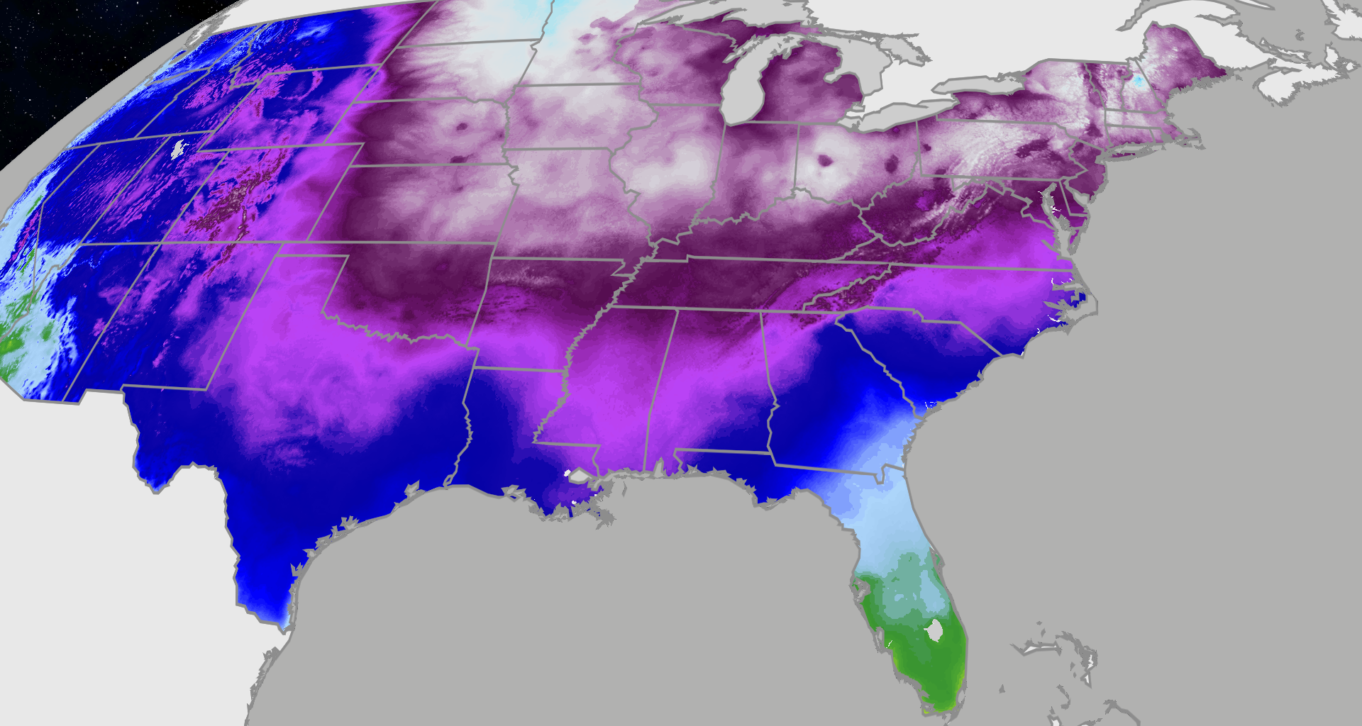
While extreme cold has settled into the eastern half of the U.S., including many across the South shivering without power after Winter Storm Fern, another shot of even colder air will spill south and east late this week and weekend.
This next round of cold air will have the potential to break records as far south as the Florida Keys, bringing not only the coldest air of the season to the Sunshine State, but possibly the coldest air in more than 15 years in parts of South Florida.
(MORE: Winter Storm Fern Recap)

Weather in your inbox
By signing up you agree to the Terms & Privacy Policy. Unsubscribe at any time.
The National Weather Service has issued extreme cold alerts in parts of the South and Ohio Valley for the cold air that’s currently in place, as the map below shows. And as the week progresses, expect these alerts to expand for the second shot of cold air.
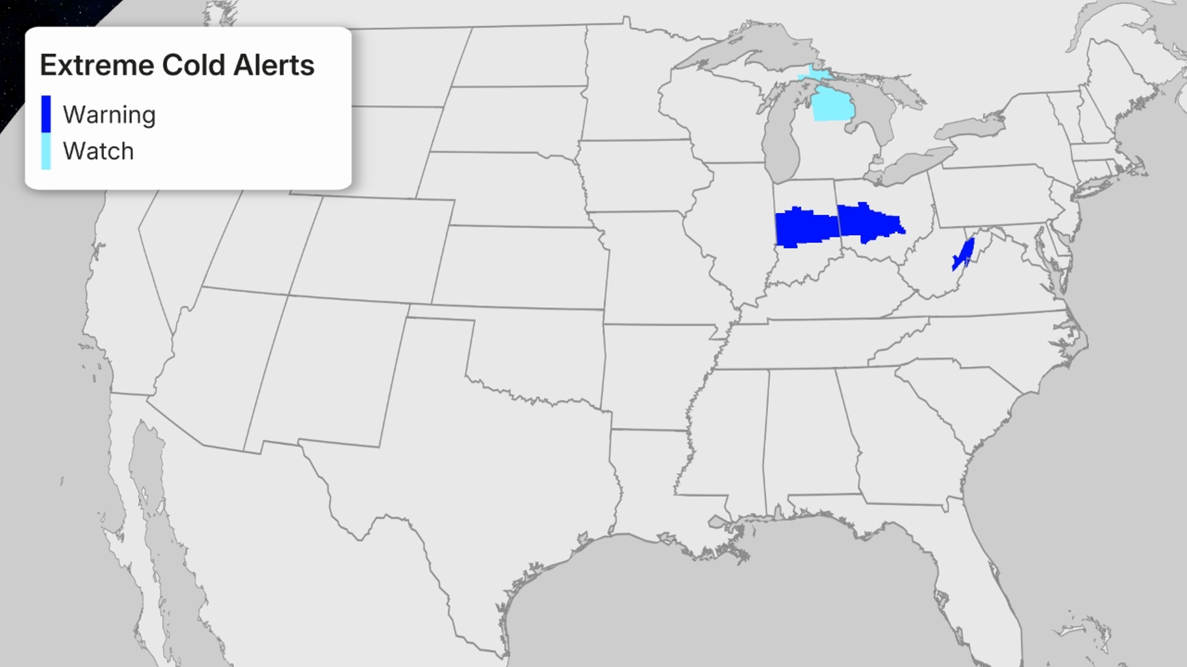
National Weather Service Extreme Cold Alerts
Many dozens of daily record cold high and low temperatures may fall by the wayside this week in the South and East. That’s tough to do during what is already the coldest time of year. By the end of the weekend, freezing temperatures could stretch as far as South Florida.
(CURRENT MAPS: Temperatures | Wind Chills)
The Ohio Valley, Mid-Atlantic, Northeast
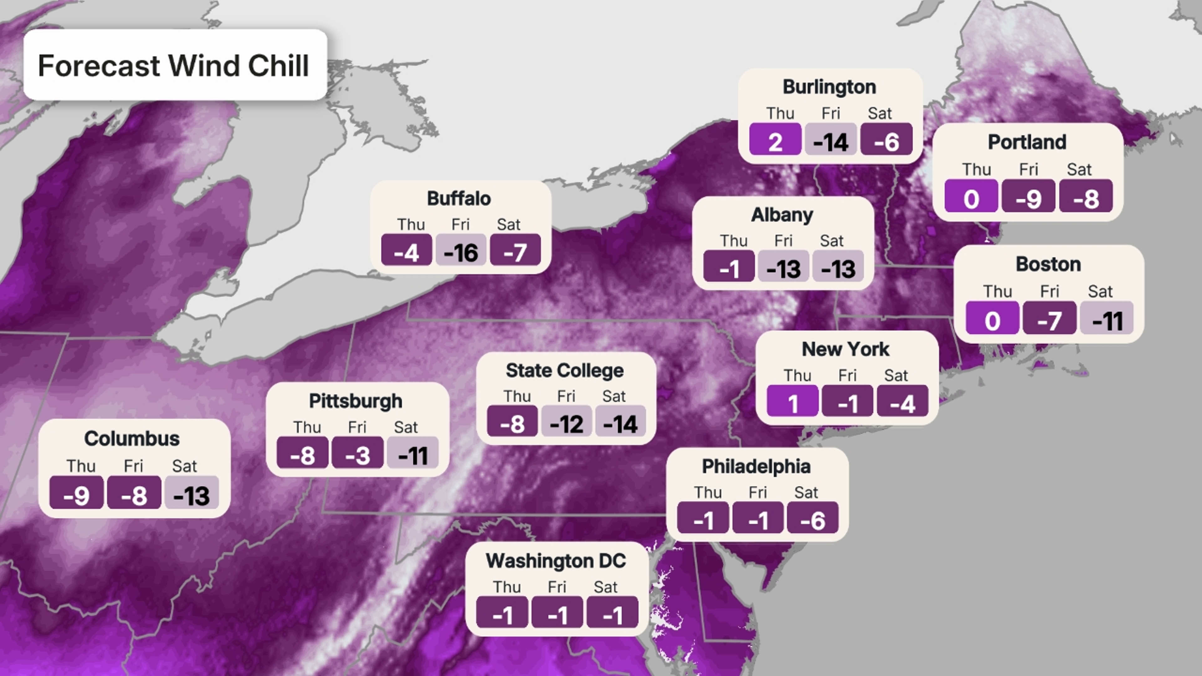
This second round of record cold will arrive in the Ohio Valley, mid-Atlantic and Northeast on Thursday and last through Saturday, with the cold peaking on Friday. We could see dozens of records fall as temperatures drop to the single digits and teens below zero from Ohio to New Jersey.
Even Washington, D.C., is expected to drop to 2 degrees Friday morning. This will be a similar trend all the way up the I-95 corridor, with many places dropping to at least zero.
When you factor in the wind chill, or the “feels like” temperature, temperatures will feel even colder.
 Deep South, Southeast
This second round of cold will arrive in the Deep South and Southeast on Friday, impacting many of the same people who have just been hit by Winter Storm Fern. Cold records could fall from Oklahoma to the Carolinas.
On Saturday, high temperatures will struggle to get above freezing, even for places like Montgomery, Alabama, and Columbus, Georgia.
(MORE: What Is Wind Chill And Why Can It Have Dangerous Consequences?)
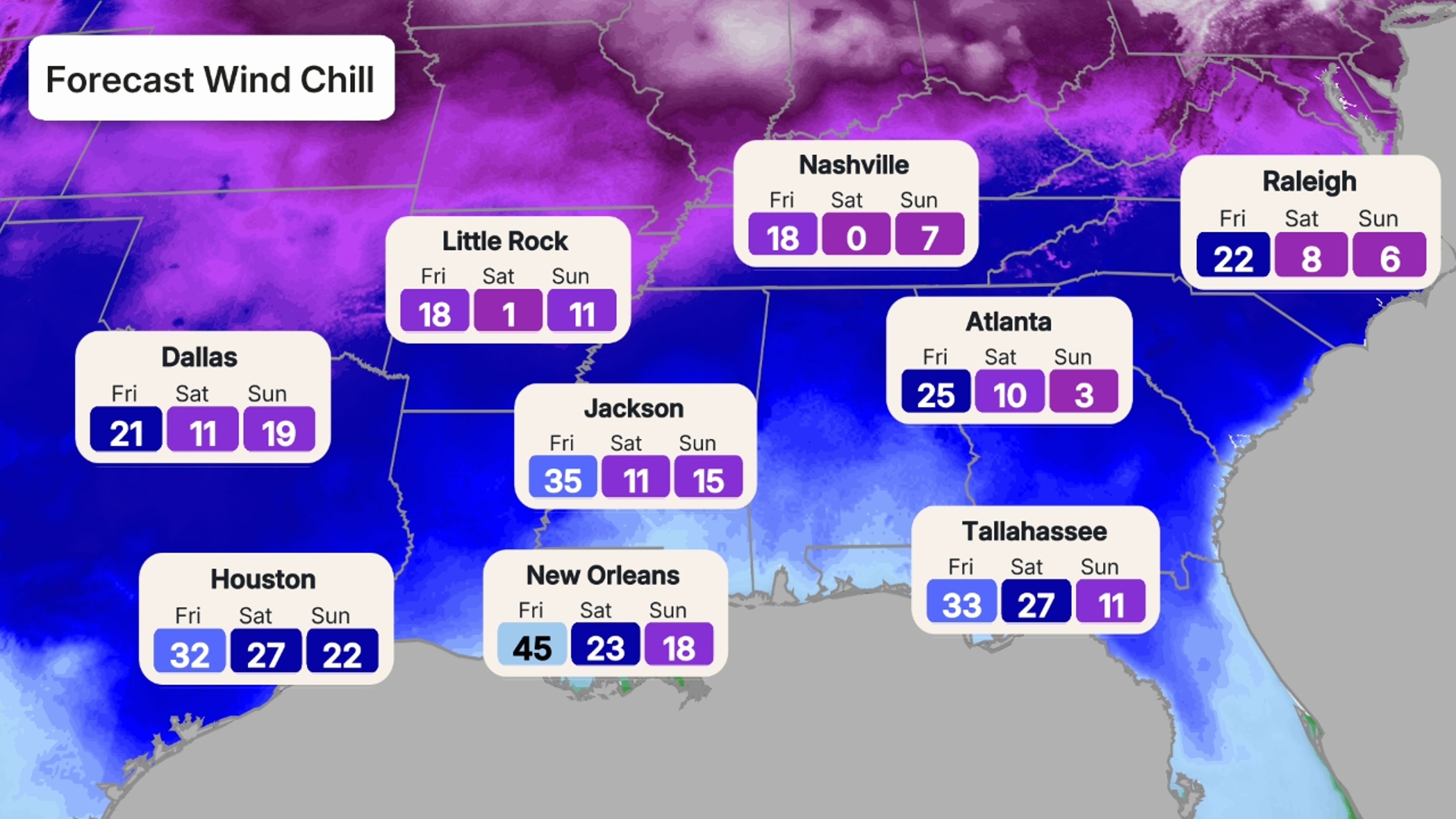
Lows bottom out Sunday morning when temperatures will drop into the teens as far south as New Orleans and the Florida Panhandle. Widespread temperatures will drop onto the teens and single digits for places in and around Atlanta, Charlotte and Nashville.
Morning wind chills in the South are forecast to stay in the single digits and teens for many places. Atlanta could wake up on Sunday morning with a wind chill of only 5 degrees.
 Yes, Florida Will Be Cold Too
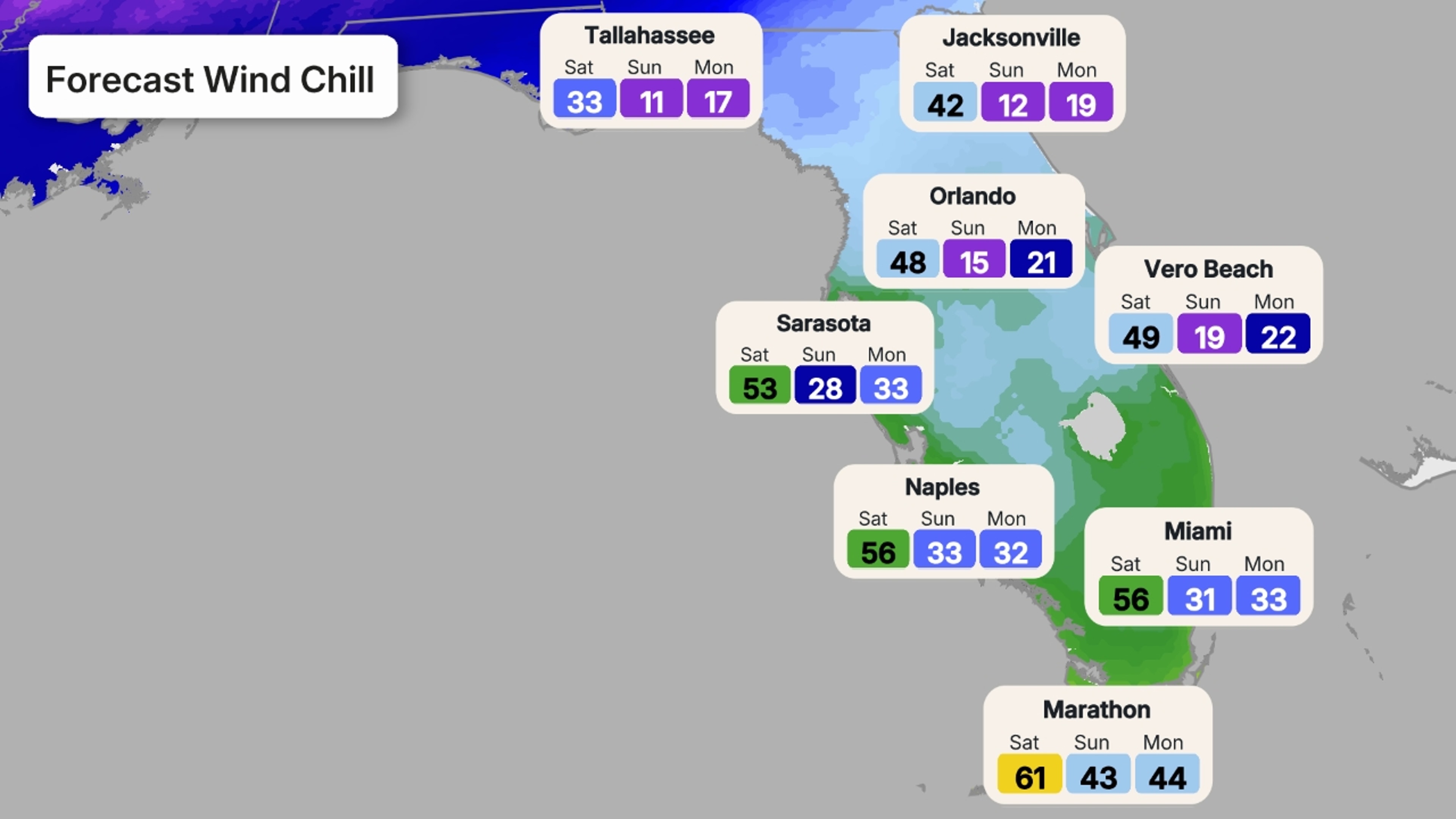
Yes, even Florida will get in on the cold this round as well. Many areas that have been enjoying temperatures in the 60s and 70s, while the rest of us freeze, will see temperatures plummet. This will by far be the coldest air of the season for the Sunshine State.
The cold air will arrive on Saturday and peak on Sunday and Monday. On Sunday morning, northern Florida will bottom out in the teens, and temperatures will drop to the 20s as far south as Orlando. Highs in central Florida Sunday may not make it out of the 40s with a stiff wind.
Even South Florida will experience the cold. Lows will be in the mid 30s as far south as Fort Lauderdale and Miami on Sunday morning, with wind chills in the 20s. Afternoon highs will only make it to the mid 50s. Even parts of the Keys will drop to the 40s Sunday morning and stay in the 50s for the afternoon.
 Records Already Set Early This Week
More than a dozen record lows were set Monday morning across the Deep South, many in just the state of Texas alone, as temperatures dropped well below freezing.
Some of the cities with new daily record lows include:
New Orleans: 27 degrees
San Antonio, Texas: 19 degrees
Austin, Texas: 19 degrees
Brownsville, Texas: 30 degrees
Tulsa, Oklahoma: 0 degrees
Springfield, Missouri: -11 degrees
What’s more impressive is that some of the old records were long-standing, meaning we haven’t seen this severe of a cold snap since the 1940s or the 1960s in some cases. In San Antonio, the previous record low was set back in the 1897.
A handful of record lows were also set Tuesday across parts of Texas, Alabama, Mississippi, Louisiana and South Carolina as morning lows Tuesday dropped below freezing yet again.
Jennifer Gray is a weather and climate writer for weather.com. She has been covering some of the world’s biggest weather and climate stories for the last two decades.