
Coldest air of the decade pushing into Southwest Florida; Snow flurries possible
The coldest air of the 2020’s is beginning to blast through the Gulf Coast, bringing the chance of snow
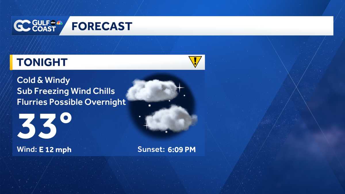
TRACKING THE POSSIBILITY OF A RARITY GUYS. I KNOW WE’RE ON FLURRY WATCHED. WHAT ARE SOME OTHER THINGS THAT WE’RE LOOKING OUT FOR? >> ALMOST CERTAINLY WE TALKED ABOUT THE WINDS. THE WINDS ARE REALLY GOING TO BE CRANKING LATER ON TONIGHT. AND THAT’S GOING TO CONTRIBUTE TO THAT WIND CHILL FACTOR AS WELL. >> IT’S GOING TO BE A COLD ONE. IT KIND OF FEELS LIKE WE’RE SOMEWHERE A BIT FURTHER NORTH RATHER THAN FLORIDA, OK? SO WHAT’S ON OUR RADAR? GUSTY WINDS AND SOME RAIN TONIGHT. THAT’S GOING TO BRING DANGEROUSLY COLD TEMPERATURES. WE HAVE FREEZE ALERTS AND COLD WEATHER ALERTS GOING UP ALL ACROSS THE GULF COAST AND THE COLD DOES CONTINUE FOR A COUPLE OF LET ME WALK YOU THROUGH IT ALL. TAKE ME OUTSIDE TO OUR RADAR. WE’RE TRACKING QUITE A FEW POCKETS OF RAIN FLYING IN FROM THE NORTHWEST. MOVING TO THE SOUTHEAST AT ABOUT 25 MILES PER HOUR. THE GOOD NEWS IS IT’S NOT BRINGING THAT HEAVY OF A DOWNPOUR. LOT OF THIS IS COMING THROUGH AS LIGHT RAIN. NOW WE’RE STARTING TO SEE THE LEADING EDGE OF IT MAKE ITS WAY THROUGH LEE COUNTY RIGHT NOW. SO RAIN BACK TOWARD CAPE CORAL AND THEN ALL THE WAY BACK OR OUT TOWARD THE GULF. WE’RE STARTING TO SEE THE SHOWERS REAPPEAR AFTER RAIN THAT WE HAD THIS MORNING. THAT’S GOING TO CONTINUE PUSHING OFF TO THE SOUTHEAST. I TIMED IT OUT FOR YOU. IT SHOULD REACH BEACHWALK PRETTY SOON. CONTINUING OFF INTO THE SOUTHEAST. EVENTUALLY HEADING BACK TOWARD IMMOKALEE AND AVE MARIA WILL DEAL WITH THIS FOR THE NEXT SEVERAL HOURS. BUT BY THE TIME THE SUN SETS, I THINK THAT WE’RE MOSTLY IN THE CLEAR WHEN IT COMES TO RAIN SPOTS PER TO EARLY TOMORROW MORNING. WE COULD SEE SOME OF THAT RAIN TRANSFER OVER INTO THE PIT. HENSCHEL POUR SOME FLURRIES WILL GET TO THAT IN JUST A SECOND. ON TOP OF THAT, WE ARE TRACKING PLENTY OF GUSTY WINDS. CURRENTLY, WIND GUSTS ARE SITTING AT ABOUT 35 MILES PER HOUR WITH GUSTS YOUR CONDITIONS OFF INTO THE GULF AND THOSE STRONG GUSTY WINDS ARE GOING TO CONTRIBUTE TO THE POTENTIAL. FOR THESE POTENTIAL FLURRIES ARE GOING SAY POTENTIAL A LOT OVER THE NEXT LITTLE BIT. SO THOSE FLURRIES IF WE START TO SEE THEM POPPING UP, IT’LL STAY MAINLY TO THE NORTH BECAUSE THOSE WINDS ARE STRONG. THEY’RE GOING TO BRING A LITTLE BIT OF HUMIDITY BACK INTO THE AIR FROM THE GULF. AND IT’S REALLY GONNA COME DOWN TO THE WIRE ON. IF WE HAVE THAT HUMIDITY, IF WE’LL SEE THESE FLURRIES POP-UP, IT WOULD BE VERY, VERY EARLY TOMORROW MORNING FOR AREAS UP NORTH WE’RE SEEING IS BLUE IS WHERE WE COULD POTENTIALLY SWITCH OVER TO THAT LURIE LIGHT. FLURRY CONSISTENCY AS THIS CONTINUES TO ROLL THROUGH. BY THE TIME WE GET TO SUNRISE, I THINK THAT WE’RE KIND OF IN THE CLEAR NOT ALL OF US ARE GOING TO SEE THESE FLURRIES. BUT FOR OUR BEST CHANCE. IT’LL BE WHEN MOST OF US ARE SLEEP BETWEEN 02:00AM AND SUNRISE. TOMORROW MORNING, HIGHER CHANCES FOR AREAS NEAR THE COAST WHERE WE START TO SEE THAT HUMIDITY COME BACK IN AND FURTHER NORTH. IF YOU HAPPEN TO SEE THIS, SEND IT OUR WAY. WE LOVE A VIDEO. YOUR REPORTS ARE SO IMPORTANT. MAKE SURE THAT YOU BE SAFE BUT HAVE FUN. IF YOU DO SEE SOME OF THESE FLURRIES OUT THERE. NOW THINGS ARE MUCH TOO WARM FOR ANY FLURRY ACTIVITY RIGHT NOW. WE’RE CURRENTLY SITTING IN THE 50’S, BUT THINGS WILL DROP VERY QUICKLY. WE’LL MAKE IT DOWN TO THE 40’S BY AROUND 8 AND THEN THINGS CONTINUE TO PLUMMET UNTIL WE SEE THE 30’S POPPING UP ACROSS THE GULF COAST. A LOT OF US ARE DIVING DOWN TO THAT FREEZING MARK. WE COULD SEE BELOW FREEZING CONDITIONS FOR OUR INLAND COMMUNITIES, SORT OF IMMOKALEE LABELLE IN ARCADIA AND AREAS UP NORTH. I THINK THAT CHARLOTTE AND DESOTO COUNTIES HAVE THE BEST CHANCE TO SEE SOME FREEZES POTENTIALLY. 29, THE DEEP CREEK AROUND FREEZING TONIGHT IN PORT CHARLOTTE. NOW IT’S BEEN A LONG TIME SINCE WE’VE SEEN WHETHER THIS COLD, ABOUT 16 YEARS. FORT MYERS AND FOR NAPLES SINCE WE’VE HAD FREEZES GORDA SAW ONE A BIT MORE RECENTLY. BUT ACROSS THE BOARD, IT IS FRIGID. MAKE SURE THAT YOU ARE PROTECTING THE 4 P’S FORTH. THIS FREEZING WEATHER, PEOPLE, PETS, PLANTS AND PIPES NEED TO MAKE SURE YOU ARE PROTECTING ALL 4 OF THEM. NOW WE ARE EXPECTING EVEN COOLER WEATHER. YOU ACCOUNT FOR THE BREEZE TOMORROW MORNING. BEYOND THAT WILL KEEP THE CHILL IN THE FORECAST ALL THE WAY THROUGH THE MORNING INTO THE AFTERNOON. WE’RE ONLY MAKING IT UP INTO THE 50’S WILL BE IN A GULF COAST WEATHER ALERT DAY READ ABOUT 25 DEGREES BELOW AVERAGE. TOMORROW AFTERNOON. WE’LL KEEP IT IN THE 50’S MONDAY. WE SLOWLY BUT SURELY TRY TO WARM UP AND THEN YET ANOTHER COLD FRONT IS ON THE WAY AS WE HEAD INTO THE END OF THE WEEK IN JUST A FEW MORE LITTLE RAIN SHOWERS. THOSE WANT TO FEEL CONFIDENT WILL COME ACROSS AS RAIN. BUT TONIGHT, MAKE SURE YOU ARE PREPARING FOR THIS FOR RIGID WHETHER TO SEND THINGS OVER TO GULF COAST. METEOROLOGIST RAFAEL TAVERN AIR TO GIVE US A FEW MORE TIPS AND TELL US WHAT WE NEED TO KNOW ABOUT THE WEATHER TONIGHT. >> IT IS GOING TO BE VERY COLD TONIGHT. WE’RE TRACKING SOME OF THAT COLDEST TEMPERATURES WE’VE SEEN IN OVER 16 YEARS. LET’S TAKE A LOOK AT HOW CLOSE WE ARE GOING TO GET TO BREAKING SOME RECORDS TOMORROW MORNING. WHEN WE WAKE UP, WE’RE FORECASTING TEMPERATURE IN FORT MYERS OF 33 DEGREES. THAT IS THE OLD RECORD. SO IT LOOKS AS THOUGH WE’RE GOING TO VERY, VERY CLOSE TO MAYBE TIME OR MAYBE EVEN POTENTIALLY BREAKING THAT RECORD PLACES LIKE GORDA. YOUR RECORD FOR TOMORROW. 35 DEGREES. WE’RE FORECASTING TEMPERATURES EVEN LOWER THAN THAT. NAPLES MAY NOT GET TO THAT RECORD, BUT IT IS GOING TO BE VERY CHILLY INDEED. AS WE LOOK TO OUR TEMPERATURES ON MONDAY MORNING, WE’RE GOING TO BE TRACKING TEMPERATURES VERY CLOSE TO THOSE RECORDS YET AGAIN. FORT MYERS FORECASTING A LOW TEMPERATURE. 33 DEGREES THAT RECORD 34. SO WE ARE EXPECTING TO BREAK THAT RECORD MONDAY MORNING. GORDA. THE FORECAST INTO FREEZING TEMPERATURE AND THAT RECORD IS 33 DEGREES. I MENTION NAPLES A LITTLE BIT WARMER. IT LOOKS AS THOUGH WE ARE GOING TO BE TRACKING VERY CHILLY CONDITIONS
Coldest air of the decade pushing into Southwest Florida; Snow flurries possible
The coldest air of the 2020’s is beginning to blast through the Gulf Coast, bringing the chance of snow

Updated: 6:58 PM EST Jan 31, 2026
Temperatures will continue to drastically drop across Southwest Florida all night, along with gusty winds. A strong cold front has pushed through the Gulf Coast, bringing dramatic changes. Gusty winds will continue tonight, and gusts as high as 40 mph are expected. These strong winds will push Arctic air into the area, and widespread 30s and 20s are expected overnight and early Sunday morning. Many areas east of Interstate 75 are expected to see sub-freezing temperatures for at least a couple of hours. Along with brutally cold conditions comes the chance of seeing rare snow across the area. Temperatures near the surface will be near freezing across the Gulf Coast, and some residual moisture could be available to produce some Gulf-effect snow. Snow flurries are possible for areas across the Gulf Coast, specifically northern counties like Desoto and Charlotte; however, Collier and Lee could also see a flurry or two. The timing of potential flurries begins very late Saturday night and early Sunday morning. Highs will struggle to warm out of the 50s Sunday afternoon, along with increasing sunshine. Daily records are likely to be broken during this polar outbreak that will begin to subside by mid-next week. Late next week, another cold front is likely, keeping things very chilly next weekend. Live Interactive RadarCheck out the interactive Gulf Coast Live RadarWatch your Gulf Coast Weather forecasts on TV or onlineHere’s where to find our latest weather forecast videoYou can also watch newscasts live or on-demand hereOr download the Gulf Coast News app to stream on your phone or tabletFollow the Gulf Coast Storm Team on social mediaChief Meteorologist Allyson Rae on Facebook and XMeteorologist Caroline Castora on Facebook and XMeteorologist Jim Dickey on Facebook and XMeteorologist Jason Dunning on Facebook and XMeteorologist Rob Duns on Facebook and XMeteorologist Lauren Hope on Facebook and XMeteorologist Raphael Tavernier on Facebook and XDOWNLOAD the free Gulf Coast News app for your latest breaking news and weather alerts. And check out the Very Local Gulf Coast app to stream news, entertainment and original programming on your TV.
FORT MYERS, Fla. —
Temperatures will continue to drastically drop across Southwest Florida all night, along with gusty winds.
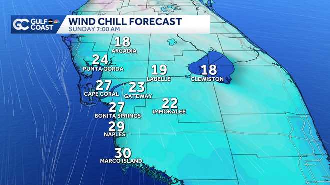
A strong cold front has pushed through the Gulf Coast, bringing dramatic changes. Gusty winds will continue tonight, and gusts as high as 40 mph are expected. These strong winds will push Arctic air into the area, and widespread 30s and 20s are expected overnight and early Sunday morning. Many areas east of Interstate 75 are expected to see sub-freezing temperatures for at least a couple of hours.
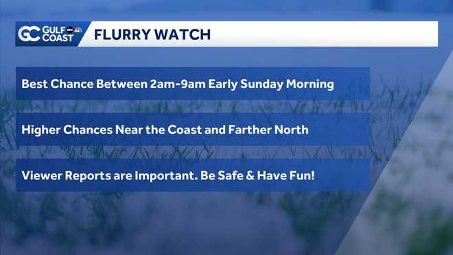
Along with brutally cold conditions comes the chance of seeing rare snow across the area. Temperatures near the surface will be near freezing across the Gulf Coast, and some residual moisture could be available to produce some Gulf-effect snow. Snow flurries are possible for areas across the Gulf Coast, specifically northern counties like Desoto and Charlotte; however, Collier and Lee could also see a flurry or two. The timing of potential flurries begins very late Saturday night and early Sunday morning.
Highs will struggle to warm out of the 50s Sunday afternoon, along with increasing sunshine.
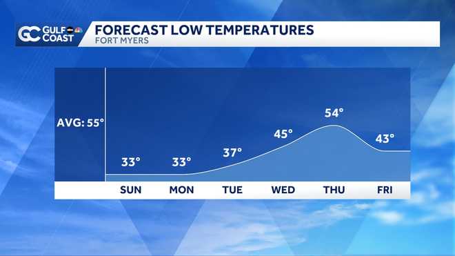
Daily records are likely to be broken during this polar outbreak that will begin to subside by mid-next week. Late next week, another cold front is likely, keeping things very chilly next weekend.
Live Interactive Radar
Watch your Gulf Coast Weather forecasts on TV or online
Follow the Gulf Coast Storm Team on social media
Chief Meteorologist Allyson Rae on Facebook and XMeteorologist Caroline Castora on Facebook and XMeteorologist Jim Dickey on Facebook and XMeteorologist Jason Dunning on Facebook and XMeteorologist Rob Duns on Facebook and XMeteorologist Lauren Hope on Facebook and XMeteorologist Raphael Tavernier on Facebook and X
DOWNLOAD the free Gulf Coast News app for your latest breaking news and weather alerts. And check out the Very Local Gulf Coast app to stream news, entertainment and original programming on your TV.