
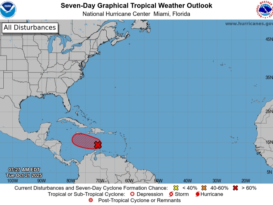
Tropical Storm Melissa is expected to form on Tuesday as a tropical wave moving through the Caribbean Sea is expected to slow down and strengthen, the National Hurricane Center said, with forecasters watching to see if the storm coalesces and proves a threat to coastal Florida.
The system, now called Invest 98L, has a near 100 percent chance of strengthening into a tropical depression or storm within the next two days, the NHC said.
Experts are also eyeing three additional tropical waves that are moving west across the Atlantic behind it, although none are expected to develop, AccuWeather said.
There are three possible tracks for Invest 98L, Matt Devitt with WINK Weather wrote in a social media post.
“A) An earlier turn northeast into Puerto Rico or Hispaniola, B) Keeps heading west into Central America, C) Heads into the Western Caribbean, takes more time and then heads northeast across Cuba and the Bahamas,” Devitt wrote, adding, “With that said, Florida is not in the clear or out of the woods yet. Remember, models are analyzing something that hasn’t even formed!”
A coming cold front would steer the storm away from Florida, experts said.
According to Devitt, “A possible blocker for Florida could be a cold front sweeping by around Halloween to pick up the system, but the TIMING of that front will be a big factor.”
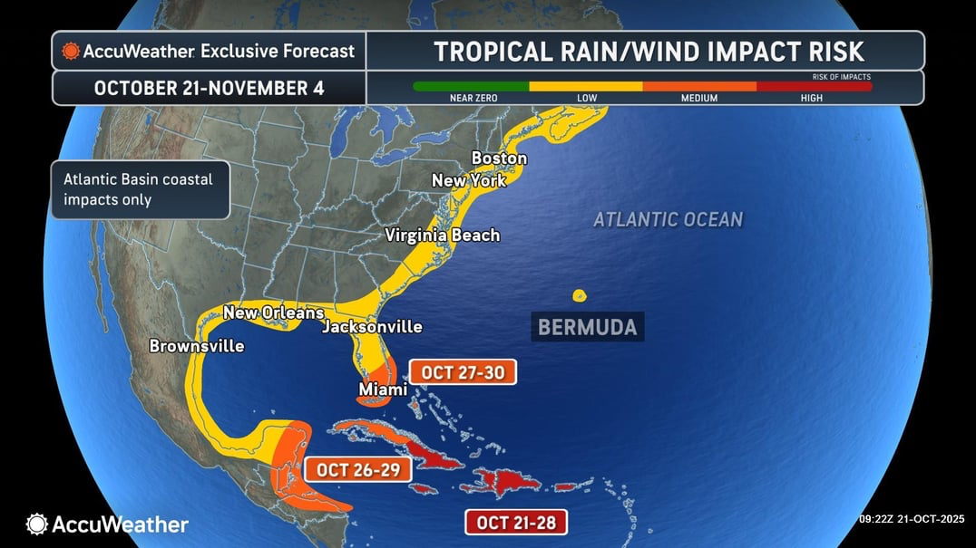
South Florida has a medium risk of tropical rain and winds from Oct. 27 to 30, according to the AccuWeather forecast. The rest of Florida is at a low risk of being impacted by the storm.
 (AccuWeather)
Invest 98L “appears to be developing a well-defined center” over the central Caribbean Sea on Tuesday morning, the NHC said. It’s already producing winds up to 45 mph.
The U.S. Air Force Hurricane Hunters are scheduled to investigate the system later on Tuesday.
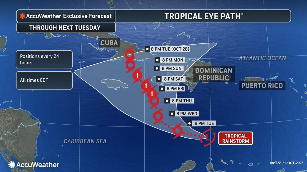
“Due to favorable conditions, the storm is expected to intensify into a hurricane as it slows down and begins to turn north late this week. It is possible that this rainstorm could undergo rapid intensification as it sits over the warm waters of the Caribbean,” Alex DaSilva, AccuWeather’s lead hurricane expert, said.
The system is expected to bring heavy rains and gusty winds to parts of Aruba, Bonaire and Curaçao over the next day or two, according to forecasters, the NHC said.
“As the storm moves northward, significant flooding and strong winds will be possible in Jamaica, Cuba and Hispaniola,” DaSilva said. “The storm could also drift farther west before making a northward turn. Interests in the Caribbean and Mexico should continue to monitor the progress of this storm, as a shift in track can bring impacts farther west.”
 (AccuWeather)
Puerto Rico could also see heavy rain and flooding, strong winds, and rough surf later this week, according to the NHC.
Jonathan Porter, AccuWeather’s chief meteorologist, is especially concerned about “the potential for a life-threatening, catastrophic flooding disaster” in the mountainous areas of Cuba, Haiti and the Dominican Republic if the storm turns north and stalls.
“These communities are especially vulnerable to flooding, as seen in major flooding disasters in this area, including Hurricane Flora in 1963, which tragically claimed over 7,000 lives. More recently, in May 2004, devastating floods occurred across Hispaniola when nearly 20 inches of rain fell. While not from a tropical storm or hurricane, this is yet another example of the flood risk in the Caribbean,” Porter said.
These areas could see 8 to 16 inches of rain from the storm with localized amounts up to 30 inches, AccuWeather forecasters said.
“Most models eventually bring [the storm] into the area between the Dominican and Cuba later this week. GFS is a bit more East and faster, but the exception is… the Euro. It’s much more West and stalls it out for days. A front will eventually pick Melissa up and move her NE, but when does that happen? The Euro is historically the best model on Earth,” Denis Phillips, chief meteorologist for Tampa Bay 28, wrote in a social media post. “None of the ensemble runs bring Melissa into the Gulf at this point. Trips to the DR will be dicey. For Florida, we watch for any unexpected changes West. I’m not saying it can’t happen, I’m saying it won’t. There’s a difference.”