
ORLANDO, Fla. – After the incredible and historic winter blast we’ve received here in town and the temps we felt during the weekend, I feel like the last thing Floridians want to hear is another six weeks of winter.
I want to set the record straight (without stepping on Punxsutawney Phil’s toes at all!).
The calendar start for the spring season isn’t until March 20. Now, granted, January felt like a blur considering it’s now February. The clock is ticking, but we’re not too close just yet.
Despite the warm up we’re tracking towards Friday the 13th and Valentines Day, we’re still going to be watching out for the next imminent wintry blast that will come down from up north (Copyright 2026 by WKMG ClickOrlando – All rights reserved.)
While another six weeks of winter are absolutely on the table, they can mean a variety of things for us Central Floridians.
For example, as we head toward Valentine’s Day, we’re actually looking at temperatures increasing so much we’ll come out of below-average territory and head right toward the above-average range once again.
Just remember one of my favorite rules of thumb: whenever heat begins to build, there’s always some cold behind it to even the playing field. While a cooldown once the warmth settles in may not be an immediate swap, rest assured our next cold front and winter storm will be on the horizon.
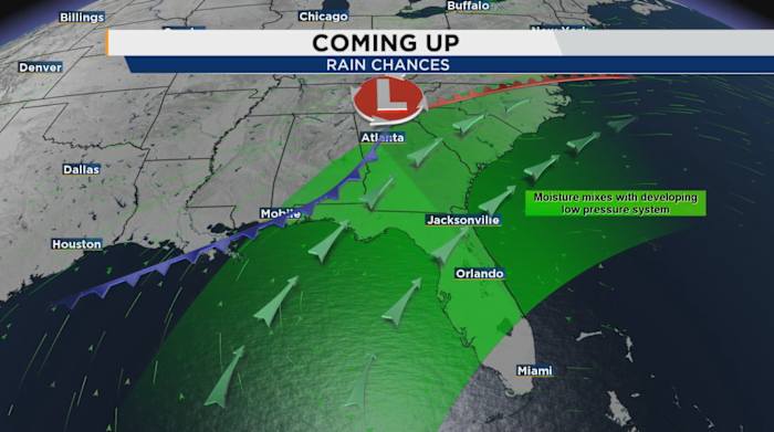
Over the next few days as the pattern starts to evolve, a pulse of energy is slated to come down and deliver us another dose of cooler air and possibly rain chances on the leading edge of this push (Copyright 2026 by WKMG ClickOrlando – All rights reserved.)
It looks like toward the backside of this month is when we’ll be bracing for another blast of cold air.
Each of our individual “teleconnections” we typically use to look far down the pike at what our weather pattern could be doing point toward the reversal from hot to cold again.
This actually confirms Punxsutawney Phil’s current forecast for the lower 48, suggesting we will indeed be in for another four to six weeks of wintry weather before things start to make the transition.
While winter is still in play for the next few days, slowly towards this weekend and especially next week the dominating ridge over the west will start to lose some of its northern extent and begin a move towards the east (Copyright 2026 by WKMG ClickOrlando – All rights reserved.)
There’s a point between winter and spring we used to call in Air Force Weather a “transition season.” This is when the atmosphere shows a noticeable response to the change in what parts of the northern hemisphere receive the most sun, where we are in our orbit around the sun and how the jet stream responds to these changes.
It looks like February could deliver another substantial blast of heavy snow for many, frigid temperatures and a drastic cool down for the Sunshine State after Valentine’s Day weekend. Then, based on our current model output, the winter season begins to say its goodbyes.
Daily Forecast
The News 6 Weather team ensures you’re always on top of the day’s weather.
Copyright 2026 by WKMG ClickOrlando – All rights reserved.