

National Hurricane Center (NHC) meteorologists have warned there is significant uncertainty in Tropical Storm Melissa’s final path as the storm is expected to strengthen to a major hurricane by early next week.
Newsweek reached out to the NHC via email for comment.
Why It Matters
Melissa is the 13th named storm of the 2025 Atlantic hurricane season and comes as meteorologists have urged people living in hurricane-prone areas to remain alert in the fall. The Atlantic hurricane season began June 1 and runs through November 30.
NHC experts anticipate Melissa will accelerate to a hurricane while warning there is “significant uncertainty” in the storm’s path, making it especially crucial that people remain vigilant and prepare to act should the storm shift their way.
What To Know
As of Wednesday, the areas of top concern are Jamaica, Haiti and the Dominican Republic. All three Caribbean countries are expecting strong winds, heavy rainfall and other life-threatening impacts, like mudslides.
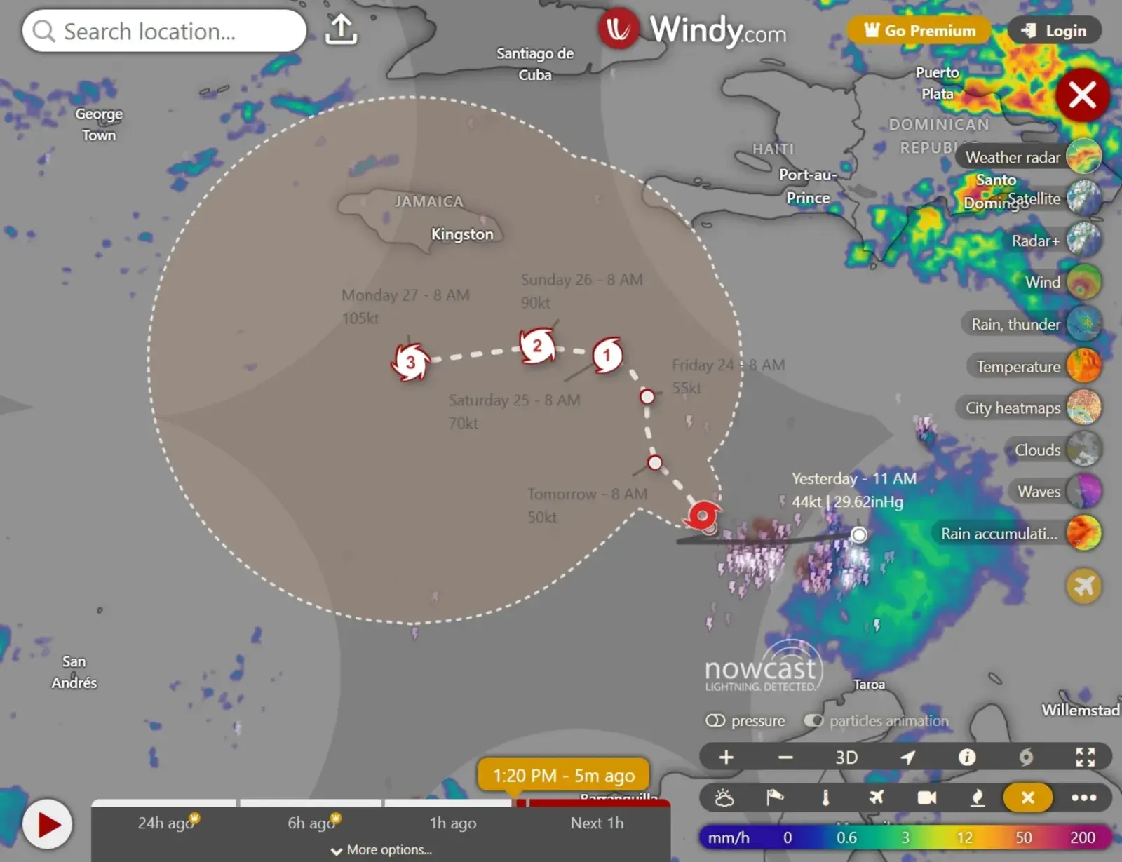
Due to questions about the storm’s path, concerns have been raised that Florida could be affected as Melissa strengthens. However, animated weather radar from windy.com shows impacts from the storm are currently far from the Sunshine State.
The strongest winds are currently south of Haiti and rain accumulation tracker maps from windy.com also show Florida is not expecting any heavy rainfall over the next three days.
AccuWeather Lead Hurricane Expert Alex DaSilva, however, previously told Newsweek that because the steering flow is light this week, the storm has a greater chance of meandering outside its forecast path.
Tropical Storm Melissa Path: Where Is the Storm Headed?
The NHC has said there is significant uncertainty in the storm path, but as of Wednesday afternoon, forecasts anticipate the storm, which is moving north, will take a westward turn to skirt the southern Jamaica coast. The storm will likely continue moving west when it becomes a major hurricane by Monday morning.
This path takes the storm even farther from Florida. However, some spaghetti models, or computer-illustrated models showing potential storm paths, anticipate the storm will turn northeast instead. Despite this, most of these models show the storm veering into the Dominican Republic or heading northeast, toward the Bahamas.
As of Wednesday afternoon, no tropical storm or hurricane watches or warnings were in place for the U.S., including Florida.
FOX 35 Orlando senior meteorologist Noah Bergren shared data on X Tuesday that shows there’s an increasing chance that Melissa will head west.
“Starting to see the potential of the ‘go west’ scenario in the models,” he posted. “If Melissa gets west of Jamaica — odds are high it will take off. HMON [Hurricanes in a Multi-scale Ocean-coupled Non-hydrostatic model] tonight shows Cat. 4/5 potential by late weekend SW of Jamaica. Intense banding into Jamaica would be an extreme flood threat even as the storm tracks west, away from the island.”
Loading twitter content…
What People Are Saying
NHC, in a public advisory on the storm: “Melissa is expected to bring 5 to 10 inches of rain to the southern Dominican Republic, southern Haiti, and eastern Jamaica through Saturday, with locally higher amounts possible. Additional heavy rainfall is possible beyond Saturday; however, uncertainty in Melissa’s track and forward speed reduces confidence in exact totals. Significant flash flooding and landslides are possible.”
NHC, in a key message about the storm: “Preparations to protect life and property should be completed by Thursday.”
What Happens Next
Meteorologists will continue tracking Tropical Storm Melissa and issuing regular updates on its path. People living in Jamaica, Haiti, the Dominican Republic and other parts of the Caribbean are urged to remain vigilant and take action to protect lives and property.