
Showers and storms arriving Friday to Central Florida
BUT WE’RE GOING TO GET SOME. IT JUST MAY BE THAT IT’S NOT A COMPLETE WASHOUT TOMORROW. SO HERE’S THE SETUP FOR US THIS AFTERNOON. STORM SYSTEM NORTH COLD FRONT APPROACHING. AND THAT’S GOING TO BE WHAT’S GOING TO HELP TO SPARK UP SHOWERS AND THUNDERSHOWERS. THEN TOMORROW THIS FRONT SAGS A LITTLE FURTHER SOUTH THAN WE FIRST THOUGHT. KEEPING THE TREASURE COAST IN THE PALM BEACHES IN THE SOGGY DAY. FOR US, IT’S GOING TO BE OUR SOUTHERN AREAS THAT WILL GET INTO SHOWERS FOR SATURDAY AND THEN INTO SUNDAY. THE ENTIRE PENINSULA DRIES OUT A BIT BEFORE WE START TO GET SOME COASTAL SHOWERS COMING IN. LOOKING AHEAD TO MONDAY OF NEXT WEEK. SO WHEN WE LOOK AT THE SEVEN DAY FORECAST, WE CAN SEE HIGHEST COVERAGE OF RAIN IS GOING TO BE TODAY AND IT’S GOING TO BE THIS AFTERNOON EVENING. THEN TOMORROW OUR SOUTHERN 40% GETS SHOWERS A BIT DRIER FOR OUR SUNDAY. AND THEN LOOKING AHEAD TO MONDAY, TUESDAY WILL BRING IN THOSE COASTAL SHOWERS. SO HERE’S FUTURECAST HELPING YOU PLAN TODAY. 3:00 POPCORN SHOWERS, ESPECIALLY OUT WEST. THEN BY DINNER TIME WE BRING THAT LINE OF RAIN IN STARTING AROUND OCALA ACROSS 40 TO PALM COAST. LITTLE BY LITTLE. THIS IS 7:00. IT SAGS INTO DELAND. IT SAGS INTO LEESBURG. ORLANDO GETS INTO THE METRO BY ABOUT 10:00 OR SO. THEN 3:00 IN THE MORNING, SOME LINGERING SHOWERS IN OUR SOUTHERN AREAS. AND THAT’S WHERE THAT’S GOING TO KIND OF STAY. SO FOR TODAY, WE’VE GOT THIS MOSTLY CLOUDY SKY, BUT THE RISING RAIN COVERAGE AFTERNOON THROUGH THE EVENING TIME FRAME. THEN LOOKING AHEAD TO TOMORROW MORNING, WE’LL HAVE A FEW SHOWERS WITH US. BUT YOU’LL NOTICE THE VAST MAJORITY OF THE ENERGY WILL KEEP RAINS BASICALLY FOR THE ORLANDO METRO OFF TO THE SOUTH. THEN LOOKING AHEAD TO NEXT WEEK, THE OVERALL UPPER AIR PATTERN BUILDS IN THIS RIDGE, WHICH BASICALLY SETS US UP FOR A WARM STRETCH OF WEATHER. LOOKING AT THE AMERICAN GFS MODEL, OKAY, TEMPERATURES STEADILY CLIMBING AND ALL THE WAY TO MID MONTH, WE’RE JUST HANGING IN THE MID 80S. SO SPRING REALLY LOOKS TO GET GOING. METEOROLOGICAL SPRING STARTS MARCH THE 1ST, WHERE OUR AVERAGE HIGH TEMPERATURES JUST CONTINUE TO CLIMB. AND THEN OF COURSE THERE’S THE WHOLE SPRING FORWARD THING. DAYLIGHT SAVING TIME BEGINS IN JUST NINE DAYS. NOT THIS WEEKEND, BUT NEXT WEEKEND. GOOD TIMES. WE NEED THE RAINFALL THOUGH. WHEN WE LOOK AT THE DROUGHT MONITOR FROM LAST WEEK TO THIS WEEK. NOT A SIGNIFICANT CHANGE IN EITHER DIRECTION, BUT ALSO NOT A SIGNIFICANT CHANGE. SO WE’RE STILL ABNORMALLY DRY AND INTO NOW A SIGNIFICANT DROUGHT THIS MORNING. WE’VE GOT SOME CLOUDS OVER TOP OF US, SOME FOG TRYING TO DEVELOP IN OUR WESTERN AREAS. NOTHING TOO TOO BAD. 50 TO THE NORTH, 60S ACROSS THE METRO. AND THE SEVEN DAY FORECAST BASICALLY SHOWS A VERY SPRING TIME MARCH TYPE PATTERN WITH HIGH TEMPERATURES IN THE 70S AND 80S THAT RUNS ABOVE AVERAGE, AND A CHANCE OF RAIN HERE OR THERE. SO I’M GLAD WE’RE NOT LOOKING AT
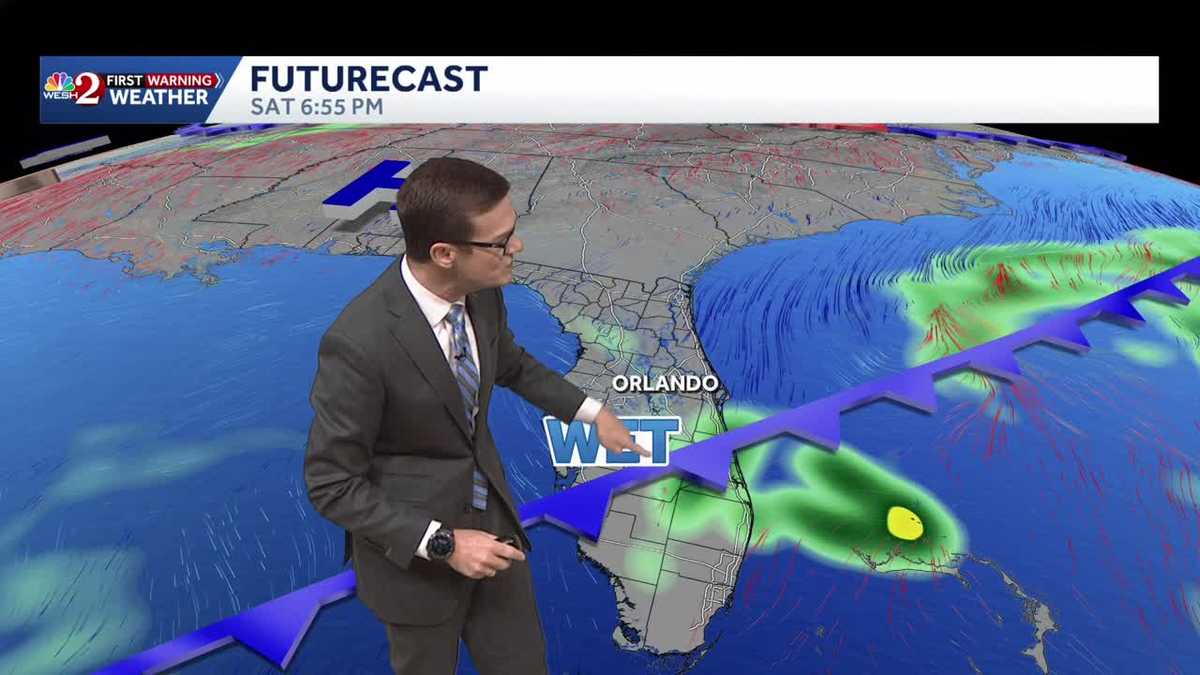
The day starts with much warmer temperatures than recently experienced, with highs expected to reach around 83 degrees.Models have trended stormier this afternoon, and the latest runs of the FutureCast model and hero show showers and even storms arriving this afternoon and evening, whereas the GFS waits a bit later. The globals also keep rain for tomorrow, but our FutureCast does not, making for a tough forecast.First Warning Weather Stay with WESH 2 online and on-air for the most accurate Central Florida weather forecast.RadarSevere Weather AlertsDownload the WESH 2 News app to get the most up-to-date weather alerts. The First Warning Weather team includes First Warning Chief Meteorologist Tony Mainolfi, Eric Burris, Marquise Meda and Cam Tran.
ORLANDO, Fla. —
The day starts with much warmer temperatures than recently experienced, with highs expected to reach around 83 degrees.
Models have trended stormier this afternoon, and the latest runs of the FutureCast model and hero show showers and even storms arriving this afternoon and evening, whereas the GFS waits a bit later.
The globals also keep rain for tomorrow, but our FutureCast does not, making for a tough forecast.
First Warning Weather
Stay with WESH 2 online and on-air for the most accurate Central Florida weather forecast.
Download the WESH 2 News app to get the most up-to-date weather alerts.
The First Warning Weather team includes First Warning Chief Meteorologist Tony Mainolfi, Eric Burris, Marquise Meda and Cam Tran.