
For 142 very pleasant days of the 2025 hurricane season, the waters of the Caribbean Sea were still. All the storms that mattered this year formed to the north or east, and then turned north in an orderly fashion towards Bermuda. And it was good.
But on the 143rd day, Tropical Storm Melissa moved over the waters. And Melissa unfortunately looks to make up for lost time heading into the weekend, posing a serious and historic threat of major hurricane impacts on Jamaica, Cuba, and the Bahamas — but little to no risk to Florida or the continental U.S.
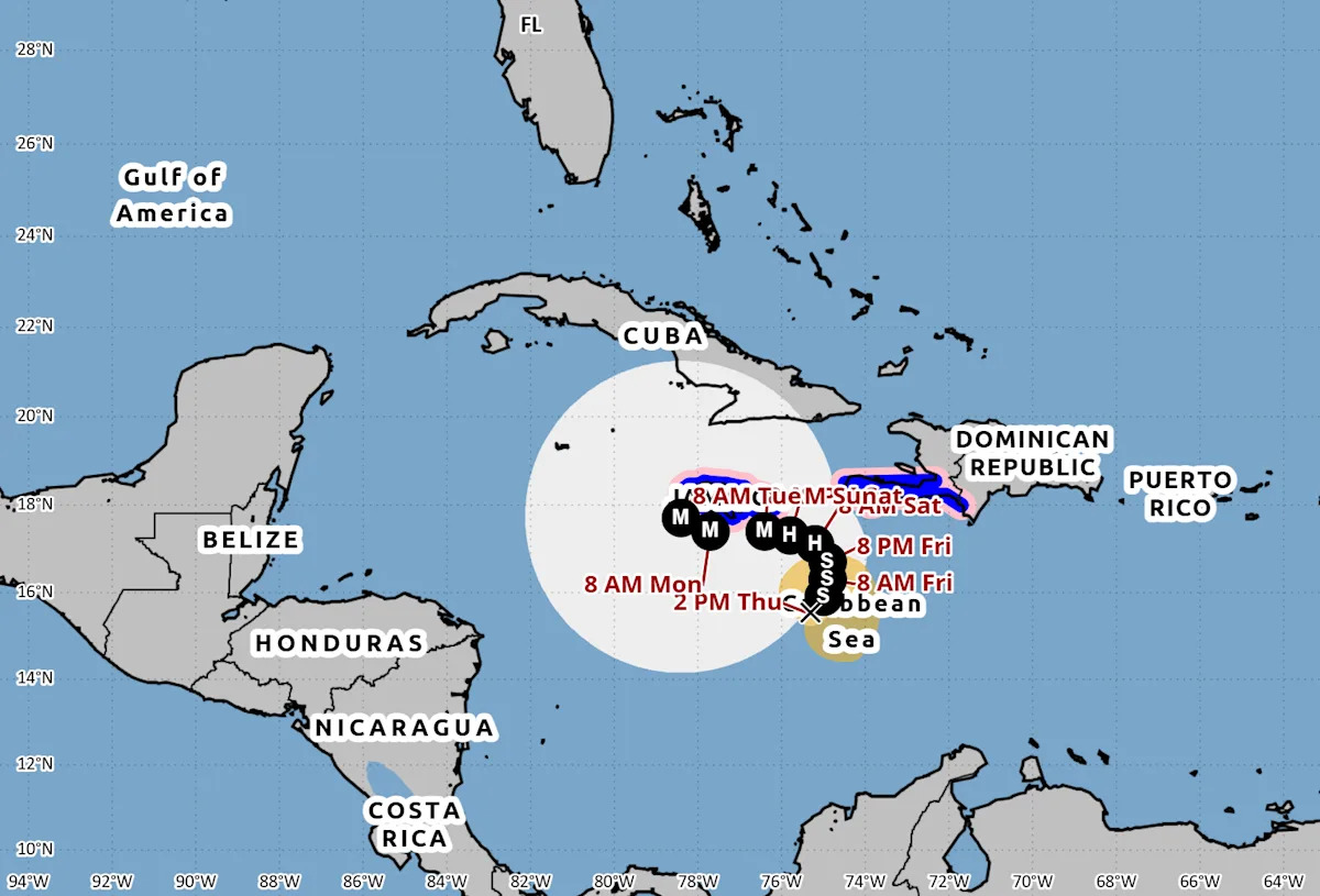
As of Friday morning, Melissa remains a messy and weak tropical storm in the central Caribbean, southeast of Jamaica and southwest of Hispaniola, with maximum sustained winds estimated at near 45 mph. Currently, Melissa is torn between the northward steering influence of eastern U.S. troughing and the southwestward influence of ridging over the western Gulf, a combination that will result in little motion or a northwestward drift into the weekend.
This mismatch in lower- and upper-level currents is also causing significant wind shear over the storm, and the center of Melissa’s circulation at the surface is still located over 100 miles west of the circulation higher up in the atmosphere.
This wind shear should gradually ease over the next couple days as the trough moves away, allowing two things to happen. First, slow westward motion should resume over the weekend, and Melissa is expected to track near or southwest of Jamaica into early next week. Second, Melissa is likely to explosively strengthen, as long as it avoids moving over land.
A monster in the making, Tropical Storm Melissa has ‘outrageous oceanic potential energy’
You see, the silence of the Caribbean this season has not been due to cooler than average waters there. Quite the opposite, in fact.
The total oceanic heat content (how warm and deep the top layers of the sea are) of the Caribbean at present only slightly lags the record levels of 2023 and 2024.
Deep, warm water can’t create hurricanes from nothing, however, and weather patterns have kept tropical disturbances from reaching into the Caribbean — until this week.
By all indications, Melissa will be moving this weekend into an environment south of Jamaica coupling outrageous oceanic potential energy with ample low- and mid-level moisture and favorable upper-level outflow. That’s a recipe for rapid intensification, defined as a storm’s maximum sustained winds increasing by 30 mph or more in a 24-hour period.
The Thursday afternoon National Hurricane Center forecast calls for rapid intensification to occur in the next 24 to 72 hours, making Melissa a major hurricane by Sunday.
While forecast intensity plateaus at Category 4 strength on Monday and Tuesday, if Melissa slips a bit further south and west over the weekend, intensification could well continue into early next week, and a third Category 5 storm of the season is a possibility.
That would be the most since 2005.
Florida and the US should be in the clear with only a chilly Halloween to fear
This all sounds scary, and if you are in the eastern half of Cuba, Jamaica, Haiti, the eastern Bahamas, or the Turks and Caicos you should be scared and preparing for severe impacts.
Before getting into what that region can expect, I do want to make very clear that Melissa is not a meaningful threat to the continental U.S., and does not rate specific preparations in Florida or anywhere else stateside.
Model consensus is strong and unchanging that a second deep dip in the jet stream will drop into the eastern U.S. in the middle of next week and sweep Melissa northeast, and keeping it moving well offshore through the end of next week.
Odds of any outer bands of Melissa even minimally scraping southeast Florida on its way out are around 5%, while the odds of a crisp, cool Halloween weekend for most of Florida are around 95%.
There is a slight chance of Melissa or its post-tropical remnants curling back towards the northeastern U.S. at the end of next week, but this is not a likely outcome. Much more probable is a path in the general direction of (where else but) Bermuda.
Melissa could bring untold suffering to Jamaica and Cuba
On the flip side of that protective cold front, Melissa’s impacts on the north-central Caribbean have the potential to rate with the region’s historical worst, including the November 1932 Cuba hurricane, Charlie in 1951, Allen in 1980, and Gilbert in 1988.
Jamaica is at the highest risk of severe wind, surge, and wind; probably their best case scenario is a weaker hurricane moving over land sooner, rather than building strength over water and then angling towards Jamaica later.
Depending on how far west Melissa gets in the next 5 days, eastern or east-central Cuba will also likely take the brunt of a major hurricane, precise path across Cuba and the eastern Bahamas or Turks and Caicos to be determined. Haiti should be east of the path of the hurricane, but flood impacts may well be severe regardless.
In short, we will be very fortunate if Melissa does not cause a humanitarian disaster in the northern Caribbean next week, even as the continental U.S. once again remains out of the crosshairs of the strange 2025 hurricane season.
Keep tabs on Melissa, as its possible intensification this weekend may well result in a fearful symmetry, but know that unless something major changes, Florida and the lower 48 has nothing to fear but fear itself this Halloween week.
Keep watching the skies.

Ryan Truchelut, WeatherTiger
Dr. Ryan Truchelut is chief meteorologist at WeatherTiger, a Tallahassee company providing forensic meteorology expert witness services and agricultural and hurricane forecasting subscriptions. Visit weathertiger.com to learn more. Email Truchelut at ryan@weathertiger.com.
This article originally appeared on Tallahassee Democrat: Hurricane Melissa forecast points to historic hit for Jamaica, Cuba