
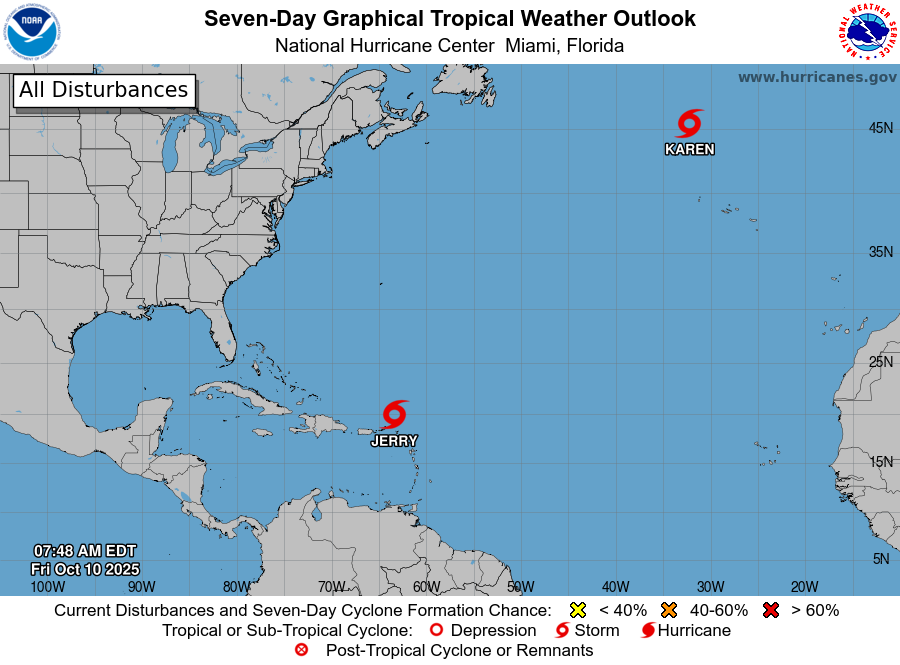
Subtropical Storm Karen has formed, joining Tropical Storm Jerry in the Atlantic.
Neither system is expected to impact the U.S. mainland, though Jerry will bring heavy rains to the Leeward Islands, British Virgin Islands, the U.S. Virgin Islands and Puerto Rico through Friday, the National Hurricane Center said.
Jerry currently has maximum sustained winds of 50 mph as it moves northwest at 17 mph. The system is expected to curve north Friday night and then northeast over the weekend away from the U.S., forecasters said.
The storm has struggled to organize, and recent aircraft and satellite data shows that Jerry’s center could be stretching out as pressure rises, indicating the system is weakening, News 6 meteorologists said.
Meanwhile, Karen is in the north Atlantic as of Friday morning, moving northeast at 9 mph with maximum sustained winds of 45 mph, NHC said.
 (National Hurricane Center)
The small storm, though sitting over cooler waters, is entangled in a large upper-level low-pressure system and Karen could start to speed up because of it, News 6 experts said.
It’s not expected to strengthen much, though, Fox 13’s Paul Dellegatto wrote in a Facebook post. “There is no manager to call because it is in the middle of nowhere. In a day or two, it will be gone.”
It’s not generally a place where a storm would form this time of year, he added.
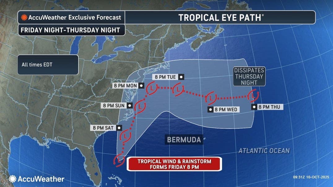
A slow-moving tropical wind and rainstorm is expected to form off Georgia’s coast on Friday and before moving north from the Carolinas to New England through early next week. The system is expected to strengthen each day and could become a named subtropical storm, AccuWeather forecasters said.
“Confidence continues to increase that a tropical wind and rainstorm will soak parts of the mid-Atlantic and Northeast later this week and through the weekend. Parts of the mid-Atlantic and Northeast could see several inches of rain, gusty winds, significant beach erosion, and prolonged coastal flooding, regardless of tropical development,” Alex DaSilva, AccuWeather’s lead hurricane expert, said. “A very stormy weekend is likely for parts of the mid-Atlantic and Northeast, especially if this storm hugs the coast or stalls. The rainstorm will have the potential to strengthen into a tropical storm as it moves over the warm waters of the Gulf Stream.”
 (AccuWeather)
AccuWeather’s chief meteorologist Jon Porter added, “Perplexingly, the government’s National Hurricane Center does not have any risk for tropical or subtropical development identified near the US East Coast through the next seven days. As such, it seems the National Hurricane Center may not ever assign a name to this storm once it develops Friday evening or may wait for the storm to exhibit certain meteorological characteristics, such as a warm core or other objective characteristics they have defined. By then, it may be way too late for people to take the needed precautions to save lives and protect property.”
Denis Phillips, chief meteorologist for Tampa Bay 28, wrote in a Facebook post that this “coastal low will bring a Nor’Easter type of storm all the way up to the Jersey Shore into early next week.”
Because it’s not a tropical system, he doesn’t expect it to be a named storm.
In Florida, the first cold front of the season is headed for the Sunshine State this weekend with lower humidity and weekend lows in the 60s, Phillips said.
Crystal River is forecast to see a low of 60 degrees, while Venice could see a low of 67, he added. “Remember, these temps are for before 8:30 am. This is still Florida. We’ll be in the 80s tomorrow [Saturday] afternoon. The humidity will be comfy all weekend.”
Matt Devitt with WINK Weather wrote in a Facebook post, “Only in Florida do people get excited about a cold front dropping high temperatures in the 80s.”