
Showers, storms return to Central Florida this afternoon
YOUR CHILDREN AT ALL TIMES WHILE IN THE WATER. AND LET’S CHECK IN NOW. FIRST WARNING METEOROLOGIST ERIC BURRIS GENTLEMAN TALKED ABOUT A LITTLE RAIN. MAYBE LATER ON TODAY. GUYS, WE’VE GOT A LITTLE BIT OF RAINFALL. BUT THE BIGGER STORY, I THINK, IS THE FACT THAT COME SPRING BREAK, YEAH, THE SPRING LIKE WEATHER GOES AWAY. I KNOW ERIC SAY IT AIN’T SO. IT IS. IT IS WINTER’S LAST STAND. SO HERE’S THE RAW COMPUTER MODELS LOOKING AHEAD TO NEXT WEEK. AND THEY’RE SHOWING A CHILLIER SETUP. LOOK AT HOW MONDAY ON BOTH MODELS IS WARMER. NOW THE GFS WANTS TO GO 86. THE EUROPEAN WANTS TO GO 79. BUT THEY BOTH REALLY TAKE A DIP ON TUESDAY AND WEDNESDAY WITH HIGHS IN THE 60S. NOW ON BOTH MODELS AND MORNING LOWS IN THE 50S OR EVEN THE 40S. SO WE’RE GONNA HAVE A LITTLE BIT OF A DIP NEXT WEEK. AND THEN WE START TO WARM UP BY THE END OF THE WEEK INTO NEXT WEEKEND. BUT I WANT YOU TO PLAN ACCORDINGLY. SO THAT’S WINTER’S LAST STAND. I THINK THAT’S GOING TO BE IT FOR THE SEASON. THEN WE’LL START TO JUST WARM UP AND WARM UP. BUT FOR NOW, YEAH, SHOWERS AND THUNDERSHOWERS ARE BACK IN THE FORECAST TODAY, ESPECIALLY IN OUR NORTHERNMOST AREAS. THAT’S WHERE WE’VE GOT THE HIGHEST CHANCE OF RAIN, ALL THANKS TO A COLD FRONT THAT’S MARCHING IN. SO HERE’S FUTURECAST ONE 130 STARTING TO BUILD THE CLOUDS INTO THE METRO. THERE’S THE RAIN’S ARRIVING 4 P.M. THAT’S WHEN WE START TO SEE THE SHOWERS AND STORMS. THIS IS NOT GOING TO BE A WASHOUT OF A DAY, BUT OVERALL COVERAGE WILL BE THE HIGHEST WE’VE SEEN IN A MINUTE THROUGH ABOUT 6:00 RAINS INTO THE METRO, 7 P.M. OR SO, WORKING IT OFF THE SHORELINE THERE. BREVARD COUNTY AND WILL BE CLEARING OUT FOR TOMORROW. SO FOR THIS AFTERNOON, 83 IN OCALA, 86 IN ORLANDO, THE AVERAGE IS 78. SO WE’RE DEFINITELY RUNNING ABOVE AVERAGE BUT LOWER THAN THE LAST FEW DAYS BECAUSE OF THE CLOUDS AND THE RAINFALL TONIGHT INTO TOMORROW MORNING, IT’S GOING TO BE A LITTLE BIT OF A COOLER STRETCH BECAUSE THE COLD FRONT WILL BE SOUTH OF US. THIS IS FRONT NUMBER ONE. THIS IS NOT A VERY STRONG ONE, BUT IT DOES HELP TO ADJUST THE TEMPERATURES A LITTLE BIT. 50 TO THE NORTH LOWER 60S THROUGH THE METRO AND HIGHS TOMORROW IN THE UPPER 70S AND LOWER 80S. SO NOT A BAD SETUP. THE TEMPERATURE TAKES A LITTLE BIT OF A DIP FOR OUR FRIDAY, THEN SATURDAY, SUNDAY, MONDAY IT STARTS TO CLIMB AGAIN. AND THEN OF COURSE TUESDAY, WEDNESDAY, THURSDAY OF NEXT WEEK, THE TEMPERATURES TUMBLE AGAIN AT THIS HOUR. WATCHING SOME CLOUDS OVER DOWNTOWN ORLANDO. OTHERWISE WE’RE COMFORTABLE. 60S TO THE LOWER 70S. NOTHING TO SEE ON OUR FIRST WARNING LIVE RADAR. SO WE ENJOY A NICE QUIET START FOR THE MORNING BUS STOP. AFTERNOON BUS STOP, THOUGH, INCLUDES THE NEED TO WATCH THE RADAR. YOU’LL WANT TO HAVE AN UMBRELLA JUST TO BE ON THE SAFE SIDE AS WE BUILD IN THOSE RAIN CHANCES 40, 50, EVEN 60% COVERAGE. SO DRIER AIR MOVES IN FOR TOMORROW. IT’S GOING TO BE A BEAUTIFUL FRIDAY, BUT THEN THAT MOISTURE BACKS UP INTO OUR AREA AND WE GET THE SHOWERS AND STORMS. NOT JUST FOR YOUR SATURDAY, BUT FOR YOUR SUNDAY AND ALSO FOR YOUR MONDAY. I GOT TO BE HONEST, SUNDAY AT THE MOMENT IS LOOKING PRETTY, PRETTY WET, 70% COVERAGE. BUT AFTER THAT, LOOK AT YOUR NEXT WEEK FORECAST TURNING MUCH COLDER ON TUESDAY. HIGH OF 65 WILL WAKE UP WEDNESDAY MORNING T
Thursday’s weather forecast includes hot temperatures with highs in the upper 80s, accompanied by afternoon showers and a few storms.Tomorrow is expected to be dry and slightly cooler, with highs around 80 degrees as a cold front moves south temporarily.As the weekend approaches, the front will lift back north, bringing a quick shower on Saturday and plenty of rain on Sunday. Another front on Monday into Tuesday is expected to bring more rain, followed by colder air. This could be the last chill of the season, with temperatures by Tuesday and Wednesday dropping to the 60s for highs and 40s to 50s for lows.First Warning Weather Stay with WESH 2 online and on-air for the most accurate Central Florida weather forecast.RadarSevere Weather AlertsDownload the WESH 2 News app to get the most up-to-date weather alerts. The First Warning Weather team includes First Warning Chief Meteorologist Tony Mainolfi, Eric Burris, Marquise Meda and Cam Tran.
ORLANDO, Fla. —
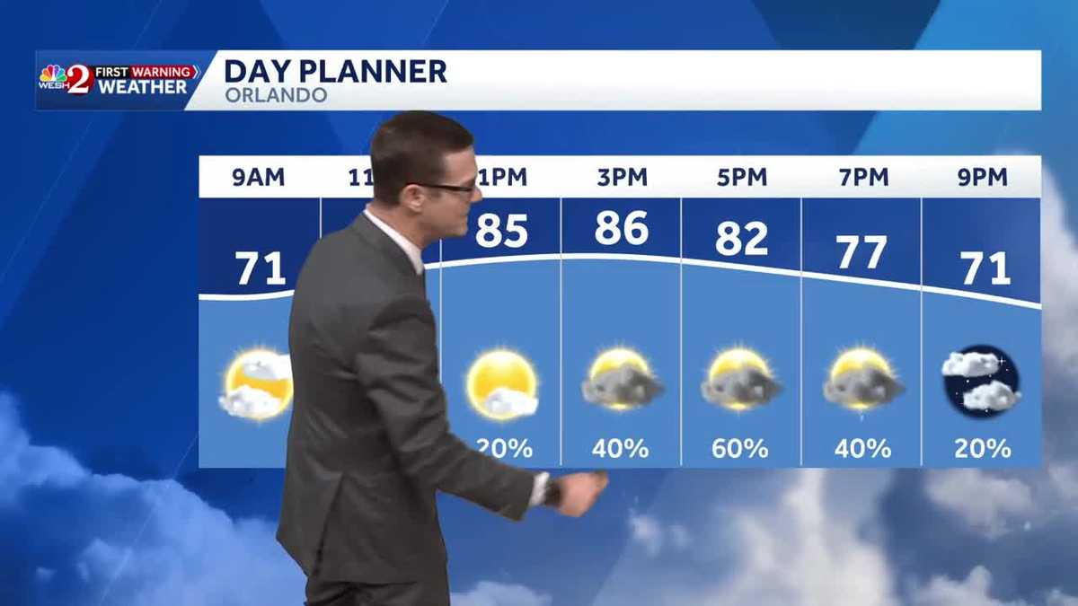
Thursday’s weather forecast includes hot temperatures with highs in the upper 80s, accompanied by afternoon showers and a few storms.
Tomorrow is expected to be dry and slightly cooler, with highs around 80 degrees as a cold front moves south temporarily.
As the weekend approaches, the front will lift back north, bringing a quick shower on Saturday and plenty of rain on Sunday.
Another front on Monday into Tuesday is expected to bring more rain, followed by colder air.
This could be the last chill of the season, with temperatures by Tuesday and Wednesday dropping to the 60s for highs and 40s to 50s for lows.
First Warning Weather
Stay with WESH 2 online and on-air for the most accurate Central Florida weather forecast.
Download the WESH 2 News app to get the most up-to-date weather alerts.
The First Warning Weather team includes First Warning Chief Meteorologist Tony Mainolfi, Eric Burris, Marquise Meda and Cam Tran.