
Central Florida could be in store for a 20-degree drop early next week giving some on Spring Break colder than expected temperatures, according to the National Weather Service.
“The front is most likely to pass through here sometime late Monday or very early Tuesday, with colder air quickly filtering in behind
it,” according to the NWS Melbourne forecaster’s discussion. “Statistical guidance suggests that highs in the mid 80s on Monday will give way to highs in the low 60s to low 70s on Tuesday (north to south). Lows are forecast to dip as cold as the low/mid 40s northwest of Orlando, with the chilliest conditions Tuesday night.”
Before the front gets here, the region should expect more seasonable temperatures and a higher chance of rain, but more unsettled weather may arrive over the weekend.
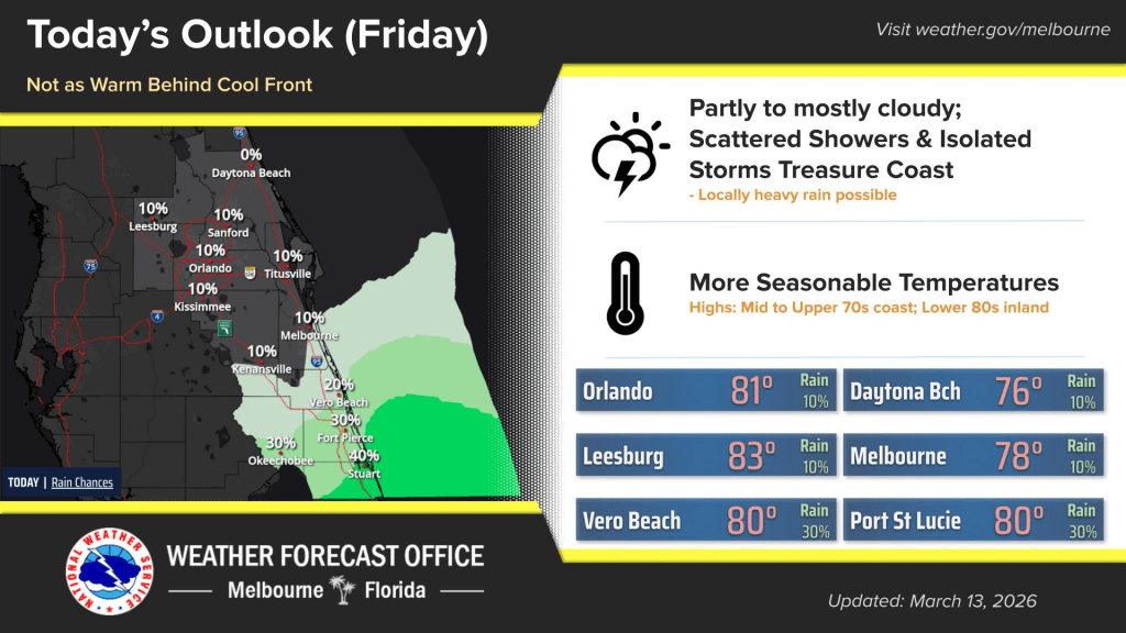
On Friday, skies will be partly to mostly cloudy behind a cool front, according to the NWS.
Light morning showers along the coast are possible, while heavier showers and isolated lightning storms are possible along the Treasure Coast during the afternoon.
All Atlantic beaches have a high risk of rip currents.
Looking ahead toward the weekend, Saturday could see scattered showers and storms.
“Timing is still somewhat uncertain, but moisture advection may support showers in the morning hours before coverage drifts toward the west in the afternoon,” forecasters said.
On Sunday, rain and storm chances are more enhanced thanks to the arrival of a “weak disturbance.”
Due to the recent drought in Central Florida, there’s no real threat from potentially excessive rainfall, but some reports see a potential for 2-4 inches in isolated spots.
Averages, however, are expected to be in the 0.5-1.25-inch range.
Excessive rainfall may not be the only danger on the weekend.
“While chances appear low and isolated, the environment may support a few strong storms with coin-sized hail and wind gusts of 40-50 mph this weekend, particularly on Sunday,” according to NWS Melbourne.
For the approaching front, there could be another round of storms on Monday.
“If the timing of the front coincides with peak heating and instability, a few strong and gusty storms may become a threat. Expect breezy and unusually warm conditions ahead of the front,” forecasters said.
Temperatures are forecast to remain below normal with highs in the upper 60s to low 70s on Wednesday, but should rise closer to normal in the mid to upper 70s by next Friday while rain chances through mid-week remain a question mark, forecasters said.