
TALLAHASSEE, Fla. (WCTV) – Another warm day is ahead to end the weekend, but big changes are looming.
Tonight Through Sunday Night
The forecast is pretty quiet for Saturday night. An isolated shower is possible, but most are looking dry and warmer. Lows dip into the upper-50s under a partly cloudy sky.
A warm Sunday is on tap across the Big Bend and South Georgia. Highs climb into the low-80s under some sunshine. We are expecting a breezy wind. We could see some gusts up to 20 mph at times.
A few showers are possible on Sunday, but we are not anticipating a washout.
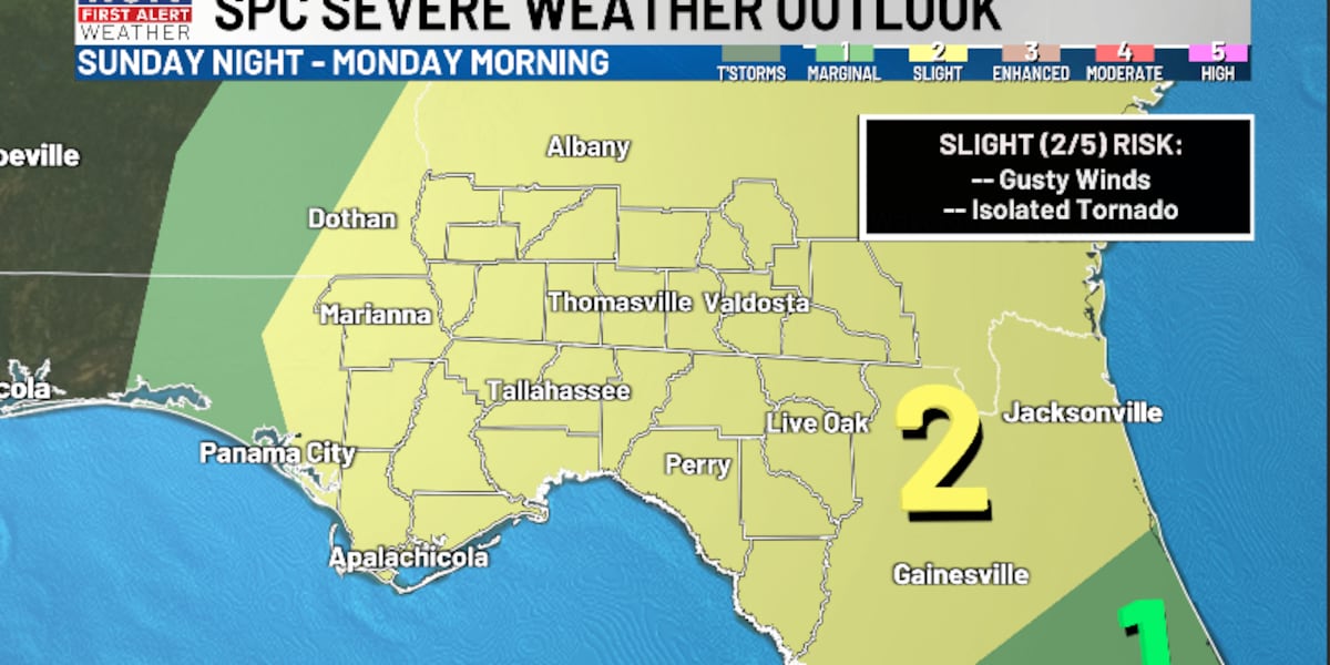
A cold front will begin to approach the region by Sunday night, and this weather system will bring showers and a few severe storms, especially late. Lows only fall into the mid-60s under a partly to mostly cloudy sky.
Monday’s Cold Front
A Level 2 Slight risk of severe weather is in place for the entire region for Sunday night and Monday morning.
TIMING: At this point, the main timing looks to be roughly 5 a.m. through noon. This could change as we get new data, so be sure to stay updated.
THREATS: The main threat will be strong, straight-line winds. However, small hail and isolated tornadoes are also possible.
Be sure to stay weather aware and have ways to get warnings for Sunday night and Monday morning.
The severe weather threat will fade away after lunchtime as a chilly airmass rushes in.
We are dry and cold for Monday night. Lows tumble into the mid-30s under a partly cloudy sky. With a breezy wind, it may feel like the low-30s to upper-20s at times.
Extended Forecast
Behind this severe weather threat, our attention turns to a blast of cold air.
We are dry on St. Patrick’s Day under a partly cloudy sky. However, temperatures only top out in the mid-and-upper-50s. Lows dip into the low-and-mid-30s. An early heads up, you may want to protect your plants for early next week.
We are looking dry and mostly sunny for the middle of the week. Highs on Wednesday top out in the mid-60s, with lows in the upper-30s.
To stay updated on all the latest forecasts and weather, follow WCTV First Alert Weather on Facebook and X (Twitter).
Click here to see all the latest weather headlines and here to view the First Alert Radar. Receive push alerts and watch the latest forecast anytime on the free WCTV First Alert Weather app. Click here to download it now.
Interested in becoming a WCTV First Alert Weather Watcher? Click here to join the team!
Copyright 2026 WCTV. All rights reserved.