
Severe Weather Warning Day in Central Florida
AND TO BRETT BOLTON, OUR LOCAL. WE’RE VERY EXCITED FOR ALL OF THEM WHO ARE COMPETING. ALL RIGHT. LET’S BRING IN FIRST WARNING METEOROLOGIST CAM TRAN BUC-EE’S CAM. WE ARE TALKING YET ANOTHER ROUND OF SHOWERS AND THUNDERSTORMS SO HEAVY THAT WE ARE CALLING FOR A SEVERE WEATHER WARNING DAY. THAT’S RIGHT. THERE’S A POTENTIAL. WE COULD SEE A LINE OF REALLY DAMAGING WINDS ROLL THROUGH WITH THIS SQUALL LINE OR LINE OF ORGANIZED THUNDERSTORMS ARE EXPECTED LATER TODAY. NOT FOR THE ENTIRE DAY IS NOT A WASHOUT. I JUST WANT TO EMPHASIZE THAT I KNOW A LOT OF FOLKS ARE ON SPRING BREAK, SO FROM NOW THROUGH ABOUT LUNCHTIME, YOU’RE IN GREAT SHAPE. IT’S JUST AFTER THAT, WE REALLY HAVE TO WATCH THE RADAR. SO HERE’S A LOOK AT THE SETUP. STRONG COLD FRONT TO OUR NORTH AND WEST. YOU CAN SEE THAT THERE. BUT UP AHEAD OF IT NOTICE THESE POP UP SHOWERS AND THUNDERSTORMS RIGHT THERE NEAR THE GULF BEND. THEY’RE IN FLORIDA. SO YOU CAN SEE WE ARE LOOKING AT SOME POP UP SHOWERS EVEN UP AHEAD OF THIS MAIN LINE. SO THE THREAT IS BASICALLY IN TWO ROUNDS TODAY. AND I’LL WALK YOU THROUGH IT WITH FUTURECAST AS WE GO THROUGH HOUR BY HOUR TIMING. RIGHT NOW, CENTRAL FLORIDA STARTING OFF PRETTY QUIET OUT THERE. DRY TO START OFF YOUR MONDAY MORNING, BUT WATCH WHAT HAPPENS AS WE GET PAST LUNCHTIME. SO FROM NOW THROUGH ABOUT ONE TO EVEN 2:00, YOU’RE IN GOOD SHAPE. BUT AFTER 2:00 YOU CAN SEE WE START TO SEE THESE LINES OF SHOWERS AND THUNDERSTORMS POPPING UP NORTH AND WEST OF ORLANDO, ALREADY IN MARION AND FLAGLER COUNTIES. THEN AROUND 3 TO 4:00, THAT LINE REALLY INTENSIFIES HEADING INTO SUMTER LAKE AS WELL AS VOLUSIA COUNTIES. YOU SEE THESE LITTLE POP UPS UP AHEAD OF THAT MAIN LINE. THOSE ARE WHAT’S CALLED DISCRETE CELLS. YOU HAVE TO WATCH THOSE CLOSELY BECAUSE IF THOSE BECOME A BIT POWERFUL, THEY COULD FIRE UP A TORNADO. SO WE ARE WATCHING THAT VERY CLOSELY AS THIS MAIN LINE PUSHES ON THROUGH. THEN AROUND 536, 7:00, THAT LINE PUSHES INTO THE ORLANDO METRO, INCLUDING THE I-4 CORRIDOR, WHICH UNFORTUNATELY MEANS A VERY WET EVENING DRIVE HOME. AND THEN BY THE TIME WE GET INTO LATE THIS EVENING, YOU SEE, BY 11:00 MIDNIGHT SHOWERS AND STORMS ALONG ON. AND WE ARE GOING TO SEE THAT COLD AIR FILTER IN BEHIND THAT FRONT. YOU CAN SEE ALL OF CENTRAL FLORIDA HIGHLIGHTED IN THE YELLOW, INDICATING A LEVEL TWO OUT OF FIVE RISK FOR SEVERE THUNDERSTORMS. BUT WE’RE NOT ALONE. YOU SEE THE ENTIRE EAST COAST PRETTY MUCH IS UNDER THAT SEVERE WEATHER THREAT TODAY, BECAUSE THIS IS A FAIRLY MASSIVE AND POTENT STORM SYSTEM THAT IS PUSHING TOWARDS THE I-95 CORRIDOR. ANY THUNDERSTORM THAT DOES BECOME SEVERE LATER TODAY, DAMAGING WINDS, I BELIEVE, IS GOING TO BE THE REALLY BIGGEST THREAT. HAIL IS ALSO A THREAT AS WELL AS TORNADOES, BUT IT’S ON THE LOWER SIDE. HEAVY RAIN IS NOT MUCH OF A THREAT TODAY. I THINK THE THUNDERSTORMS WILL MOVE A LITTLE BIT FASTER THAN WHAT WE SAW YESTERDAY. MOST LOCATIONS EXPECTED TO PICK UP AN INCH OF RAIN OR LESS. TAKE A LOOK AT YOUR AFTERNOON HIGHS. IT’S GOING TO BE WARM BEFORE THAT AREA. AREA COLD FRONT ARRIVES AND BRING US THE RAIN. WE’RE TALKING ABOUT TEMPERATURES IN THE MID TO LOW 80S. AND EVEN OUTSIDE OF THOSE THUNDERSTORMS IT’S GOING TO BE A WINDY DAY. WINDS WILL BE OUT OF THE WEST SOUTHWEST AT ABOUT 10 TO 20MPH. SUSTAINED, GUSTING UP TO 30 AT TIMES. SO BECAUSE WE HAVE THAT POTENTIAL FOR SEVERE WEATHER, WE DO HAVE A SEVERE WEATHER WARNING TODAY, ESPECIALLY BETWEEN THE HOURS OF ABOUT 7 TO 2 TO 7:00 TONIGHT. AND THEN TOMORROW MORNING, THE BOTTOM DROPS OUT. IT IS GOING TO BE A CHILLY START. TEMPERATURES IN THE 40S AND WE’RE TALKING EVEN 30S IN OCALA TOMORROW MORNING. AND THEN HIGHS TOMORROW AFTERNOON, BARELY MAKING IT INTO THE LOW 60S. SO IT’S GOING TO BE SIGNIFICANTLY COLDER BEHIND THAT FRONT. AND THAT WILL BE THE CASE ON WEDNESDAY AS WELL. AS WE TAKE A LOOK AT YOUR CENTRAL FLORIDA CERTIFIED MOS
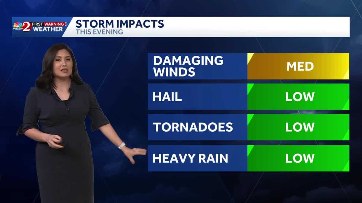
Central Florida is under a level 2 out of 5 risk for severe weather today as a strong cold front moves through the region, bringing the threat of damaging winds and tornadoes.The threat of strong and severe storms comes in two parts. First, a squall line currently moving over the northern Gulf is anticipated to reach central Florida this afternoon. This line could produce damaging winds. Additionally, ahead of the squall line, it is important to monitor “discrete” cells, which are standalone storms with the potential to produce tornadoes, contributing to the slightly higher severe risk today.The timing of the storms is projected between 2 p.m. and 7 p.m., which may affect the afternoon drive. Following the passage of this front, temperatures are expected to drop on Tuesday and Wednesday before moderating later in the week.First Warning Weather Stay with WESH 2 online and on-air for the most accurate Central Florida weather forecast.RadarSevere Weather AlertsDownload the WESH 2 News app to get the most up-to-date weather alerts. The First Warning Weather team includes First Warning Chief Meteorologist Tony Mainolfi, Eric Burris, Marquise Meda and Cam Tran. What is a Severe Weather Warning Day?A Severe Weather Warning Day suggests weather conditions that could potentially harm life or property.
ORLANDO, Fla. —
Central Florida is under a level 2 out of 5 risk for severe weather today as a strong cold front moves through the region, bringing the threat of damaging winds and tornadoes.
The threat of strong and severe storms comes in two parts. First, a squall line currently moving over the northern Gulf is anticipated to reach central Florida this afternoon. This line could produce damaging winds.
Additionally, ahead of the squall line, it is important to monitor “discrete” cells, which are standalone storms with the potential to produce tornadoes, contributing to the slightly higher severe risk today.
The timing of the storms is projected between 2 p.m. and 7 p.m., which may affect the afternoon drive.
Following the passage of this front, temperatures are expected to drop on Tuesday and Wednesday before moderating later in the week.
First Warning Weather
Stay with WESH 2 online and on-air for the most accurate Central Florida weather forecast.
Download the WESH 2 News app to get the most up-to-date weather alerts.
The First Warning Weather team includes First Warning Chief Meteorologist Tony Mainolfi, Eric Burris, Marquise Meda and Cam Tran.
What is a Severe Weather Warning Day?
A Severe Weather Warning Day suggests weather conditions that could potentially harm life or property.