
Strong storms are moving into Central Florida; multiple counties under severe thunderstorm warnings
FROM WESH TWO. FIRST WARNING WEATHER. THIS IS A SEVERE WEATHER UPDATE. AND GOOD AFTERNOON, EVERYBODY. I’M CHIEF METEOROLOGIST. TONY MAINOLFI. THUNDERSTORMS ARE RAPIDLY DEVELOPING. NOW WE’RE WATCHING THIS THUNDERSTORM NEAR APOPKA. THIS IS GOING TO BUILD QUICKLY NOW TO THE NORTH AND EAST AT ABOUT 40 MILES AN HOUR. NOW IT DOES HAVE SOME ROTATION ALOFT. SO WE’RE GOING TO HAVE TO WATCH IT. IF YOU’RE KYIV SPRINGS LONGWOOD LAKE, MARY SANFORD, DEBARY, DELTONA, LAKE HELEN AND FARM TOWN BETWEEN NOW AND ABOUT 245, THIS SEVERE THUNDERSTORM IS GOING TO BE LIFTING TO THE NORTH AND EAST. THERE IS A LITTLE BIT OF A HAIL CORE HERE AS WELL. THAT’S HEADED TOWARDS MARKHAM WOODS ROAD, BACK TOWARDS THE HEATHROW AREA ON THE NORTHWEST SIDE OF WEKIWA SPRINGS. THE OTHER THING WE WANT TO TAKE A LOOK AT HERE ARE THE WINDS. WE’LL GO AHEAD AND LOOP THIS. NOW I WANT TO SHOW YOU THE EVOLUTION OF THAT STORM. THERE’S A POCKET RIGHT THERE. IF WE SWITCH IT ON OVER TO THE MELBOURNE VELOCITY PRODUCT, AS WE’RE VERY CLOSE TO IT, THIS IS THE AREA YOU CAN SEE THE BRIGHTER SHADES OF GREEN AND THE BRIGHTER SHADES OF RED. THAT’S WHERE THERE’S A LITTLE BIT OF BROAD ROTATION NOW APPROACHING HEATHROW ON THE SOUTHWEST SIDE. NOW AT ABOUT 40 MILES AN HOUR. SO WE’RE GOING TO WATCH THAT CELL AS IT MOVES TOWARDS THE I-4 CORRIDOR. AS WE GET DEEPER INTO THE AFTERNOON, AS WE WANDERED OUT THE VIEW, I JUST WANT TO SHOW YOU WE HAVE A TORNADO WATCH NOW IN EFFECT FOR THE NORTHERN REACHES OF OUR VIEWING AREA FROM SUMTER COUNTY, MARION COUNTY BACK UP TOWARDS VOLUSIA COUNTY. NOTICE THESE DISCRETE CLUSTERS OF STORMS. WE’RE GOING TO BE WATCHING THESE DEVELOPING OUT AHEAD OF THE MAIN LINE. OF COURSE, WE’LL KEEP YOU POSTED THROUGHOUT THE COURSE OF THE AFTERNOON AS THESE STORMS RAPIDLY BEGIN TO DEVELOP ACROSS CENTRAL F
Strong storms are moving into Central Florida; multiple counties under severe thunderstorm warnings

Updated: 2:25 PM EDT Mar 16, 2026
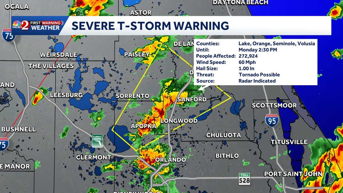
A severe thunderstorm warning was issued for multiple counties across Central Florida on Monday. The severe thunderstorm warning was issued for Seminole, Volusia and Flagler counties until 3 p.m.The storm poses hazards of 60 mph wind gusts and quarter-size hail. Current projections show storms moving into Central Florida between about 2 p.m. and 7 p.m., which could impact the afternoon commute.First Warning Weather Stay with WESH 2 online and on-air for the most accurate Central Florida weather forecast.RadarSevere Weather AlertsDownload the WESH 2 News app to get the most up-to-date weather alerts. The First Warning Weather team includes First Warning Chief Meteorologist Tony Mainolfi, Eric Burris, Marquise Meda and Cam Tran.
Central Florida —
A severe thunderstorm warning was issued for multiple counties across Central Florida on Monday.
The severe thunderstorm warning was issued for Seminole, Volusia and Flagler counties until 3 p.m.
The storm poses hazards of 60 mph wind gusts and quarter-size hail.
Current projections show storms moving into Central Florida between about 2 p.m. and 7 p.m., which could impact the afternoon commute.
First Warning Weather
Stay with WESH 2 online and on-air for the most accurate Central Florida weather forecast.
Download the WESH 2 News app to get the most up-to-date weather alerts.
The First Warning Weather team includes First Warning Chief Meteorologist Tony Mainolfi, Eric Burris, Marquise Meda and Cam Tran.