
The National Weather Service has issued a tornado watch in Tallahassee on Monday, March 16, from 8:02 a.m. until 2:00 p.m. This warning applies to Dixie, Franklin, Gadsden, Gulf, Jefferson, Lafayette, Leon, Liberty, Madison, Taylor, Wakulla, Baker, Ben Hill, Berrien, Brooks, Colquitt, Cook, Decatur, Dougherty, Grady, Irwin, Lanier, Lee, Lowndes, Miller, Mitchell, Thomas, Tift, Turner and Worth counties.
Also, a severe thunderstorm warning was issued by the National Weather Service in Tallahassee at 8:01 a.m. on Monday, March 16. This warning applies to Jefferson, Leon and Wakulla counties. Meteorologists warn of winds as strong as 60 mph. Use caution, officials warn of hail as large as 0.75 inches.
The NWS warns: “Remain alert for a possible tornado! Tornadoes can develop quickly from severe thunderstorms. If you spot a tornado go at once into the basement or small central room in a sturdy structure. For your protection move to an interior room on the lowest floor of a building. A Tornado Watch remains in effect until 2:00 p.m. EDT for Big Bend Florida.”
Tallahassee area weather radar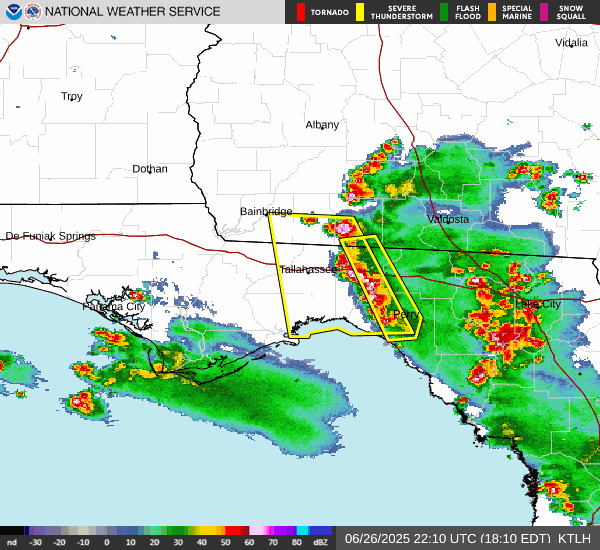 What are NWS meteorologists saying?
At 8:02 a.m., the NWS issued a statement including the following information:
“THE NATIONAL WEATHER SERVICE HAS ISSUED TORNADO WATCH 65 IN EFFECT UNTIL 2 p.m. EDT /1 p.m. CDT/ THIS AFTERNOON FOR THE FOLLOWING AREAS IN FLORIDA THIS WATCH INCLUDES 11 COUNTIES IN BIG BEND FLORIDA DIXIE FRANKLIN GADSDEN JEFFERSON LAFAYETTE LEON LIBERTY MADISON TAYLOR WAKULLA IN PANHANDLE FLORIDA GULF IN GEORGIA THIS WATCH INCLUDES 19 COUNTIES IN SOUTH CENTRAL GEORGIA BEN HILL BERRIEN BROOKS COLQUITT COOK IRWIN LANIER LOWNDES THOMAS TIFT TURNER WORTH IN SOUTHWEST GEORGIA BAKER DECATUR DOUGHERTY GRADY LEE MILLER MITCHELL THIS INCLUDES THE CITIES OF ABBA, ADAMS BEACH, ADEL, ALBANY, ALFORDS, ALMA, APALACHICOLA, ASHBURN, ASHTON, ATHENA, AUSMAC, BABCOCK, BAINBRIDGE, BANNOCKBURN, BARNEYVILLE, BAY CITY, BEACHTON, BELLVIEW, BERRIEN CO A/P, BETHEL, BEVERLY, BLUE SPRINGS, BLUE SPRINGS, BOWENS MILL, BOYD, BOYKIN, BRADFORDVILLE, BRANCHVILLE, BROOKS CO A/P, BUCELL JUNCTION, BUCK SIDING, BUCKVILLE, CABBAGE GROVE, CAIRO, CAMILLA, CAPEL, CAPITOLA, CAPPS, CARBUR, CARRABELLE, CASA BLANCO, CHAIRES, CHAIRES CROSSROADS, CHATTAHOOCHEE, CHERRY LAKE, CHULA, COLQUITT, COOK CO A/P, COOKS HAMMOCK, COOKTOWN, COTTLE, COTTON, COURTHOUSE, CROSS CITY, CROSS CITY AIRPORT, DALKEITH, DAY, DECATUR CO A/P, DILLON, DILLS, DIXIE, DRIFTON, EAST ALBANY, ELMODEL WMA, ELPINO, EMPRESS, ENTERPRISE, FESTUS, FITZGERALD, FITZGERALD MUNICIPAL A/P, FORRESTER, FORT GADSDEN, GAMMAGE, GORDY, GRADY CO A/P, GREGGS, GROOVERVILLE, HANOVER, HANSON, HARDIN HEIGHTS, HARDING, HAWKINSTOWN, HILLIARDVILLE, HINES, HOBBY, HOGGARD MILL, HONEYVILLE, HOPEWELL, HOWARD CREEK, IRWINVILLE, ISABELLA, IVEYS MILL, JARROTT, JONESBORO, KILLEARN ESTATES, KILLEARN LAKES, LACONTE, LAKELAND, LEESBURG, LITTMAN, LOCKETT CROSSING, LOVETT, LYNN, MACLAY STATE GARDENS, MADISON, MASSEE, MAYHAW, MAYO, METCALF, MIDWAY, MILFORD, MITCHELL CO A/P, MONCRIEF, MONTICELLO, MOULTRIE, MOULTRIE MUNICIPAL A/P, NANKIN, NASHVILLE, NEWTON, OAK GROVE, OCILLA, ODENA, OLD TOWN, PALMYRA, PASCO, PELHAM, PERRY, PINE PARK, PINE VALLEY, PINETTA, PORT ST. JOE, PRETORIA, QUEENSLAND, QUINCY, QUINCY AIRPORT, QUITMAN, RED ROCK, RED STORE CROSSROADS, SANTA CLARA, SMITHVILLE, SOPCHOPPY, SOUTHWEST GA REGIONAL A/P, SPENCE AIRPORT, ST. MARKS, STEINHAM STORE, SUNSWEET, SWEETWATER, SYLVESTER, SYLVESTER AIRPORT, TALLAHASSEE, TEETERVILLE, THOMASVILLE, TIFTON, TILTON, TURNER CITY, VALDOSTA, VALDOSTA REGIONAL AIRPORT, WAKULLA SPRINGS, WALKER, WATERLOO, WEBER, WEST BAINBRIDGE, WESTWOOD, WETUMPKA, WEWAHITCHKA, WHITE CITY, WORTH, AND YELLOW JACKET.”
How do you stay safe during a tornado?
During a tornado, the National Weather Service recommends:
Get as low as possible. A basement below ground level or the lowest floor of a building offers the greatest safety.
Put as many walls between yourself and the outside as possible.
Remember, tornadoes can move across hills and even bodies of water, so always seek shelter if one is nearby. Your elevation or proximity to water are not natural sources of protection.
What should you do if you’re driving during a tornado warning?
If you’re driving, especially on interstates or highways, do not try to outrun a tornado. They can move quickly and change direction without warning.
If a tornado warning is in effect, look for ways to safely leave the road and get out of your vehicle. The safest option is to seek shelter in a sturdy building.
If no building is available, avoid taking cover under a highway overpass. While it might seem protective, overpasses can act as wind tunnels, increasing wind speed and the risk of injury.
Instead, lie flat in the nearest depression, ditch, or culvert and cover your head with your arms.
What is a tornado watch?
A tornado watch means that conditions are favorable for tornadoes to develop in and around the watch area. It doesn’t mean a tornado is occurring, but it signals that the necessary ingredients, such as strong wind shear, atmospheric instability and lift, are present.
When a tornado watch is issued, make sure you have multiple ways to receive weather updates and a safety plan ready in case a tornado warning is issued.
What is a tornado warning?
A tornado warning is a more serious alert, indicating that a tornado is either happening or is about to happen, and you should take shelter immediately.
There are two types of alerts:
Radar-indicated warning: Strong rotation is detected; a tornado may form or is in the process of forming. When a warning is radar-indicated, it typically means the radar has detected a rotating thunderstorm (called a mesocyclone) capable of producing a tornado. However, not all radar-indicated warnings result in an actual tornado touchdown.
Confirmed warning: A tornado has been spotted or detected by radar through a debris signature.
Regardless of whether the warning is radar-indicated or confirmed, it is critical to take shelter immediately, as tornadoes can form quickly and radar cannot always capture what’s happening at ground level.
Florida weather watches and warningsStay informed. Get weather alerts via text.
This weather report was generated automatically using information from the National Weather Service and a story written and reviewed by an editor.
See the latest weather alerts and forecasts here.
This article originally appeared on Tallahassee Democrat: Tornado watch issued for much of Big Bend in Florida, NWS says