
OUTDOOR THIS WEEKEND. WE COULDN’T ASK FOR NICER WEATHER. HERE’S A LOOK AT YOUR 70 OFF THE TOP. WHETHER IT’S MEGACON, HEADING OUT TO THE BEACHES OR LOCAL THEME PARK, THIS WEEKEND’S WEATHER IS PERFECT AND I HIGHLY SUGGEST YOU GO OUT AND ENJOY IT BECAUSE SOME RAIN SHOWERS ARE GOING TO BE RETURNING TO THE FORECAST SOON. ALTHOUGH IT IS MUCH NEEDED RAIN THOUGH. SO TODAY, TOMORROW, MONDAY. PERFECT SUNSHINE 82. YOUR HIGH THIS AFTERNOON 85. THE HIGH ON SUNDAY. WE DO CRANK UP THE HEAT TO AROUND 86 THOUGH ON MONDAY AND THEN ON TUESDAY WEDNESDAY OF NEXT WEEK. WE DO HAVE A COLD FRONT THAT’S GOING TO BE HEADING OUR WAY AND THAT FRONT’S GOING TO STALL OUT. AND THAT’S GOING TO KEEP RAIN SHOWERS AROUND BOTH TUESDAY AND WEDNESDAY. AND A COUPLE OF SHOWERS AROUND FOR THURSDAY OF NEXT WEEK. BUT NOTICE BEHIND THAT FRONT OR AFTER THAT FRONT FADES OUT, WE ARE NOT TALKING ABOUT ANY MAJOR COOL DOWN AT ALL. SO WE’RE NOT TALKING ABOUT LAST WEEK WHEN WE WENT LITERALLY FROM THE 80S AND THEN TEMPERATURES DOWN INTO THE 30S AND 40S. SO STUNNING SUNSHINE THIS WEEKEND. AND THAT’S GOING TO BE THE CASE FOR MONDAY AS WELL, WITH ALL COURTESY OF HIGH PRESSURE IN CONTROL. IT’S GOING TO BE WARM. AND THEN ON TUESDAY, THAT FRONTAL BOUNDARY ARRIVES AND THEN IT SITS OVER US. SO THAT’S WHY WE’RE GOING TO SEE RAIN NOT ONLY TUESDAY BUT ALSO WEDNESDAY OF NEXT WEEK. AND THEN A COUPLE SHOWERS WILL LINGER INTO THURSDAY, ESPECIALLY FOR OUR BEACH LINE COMMUNITIES. SO JUST WANT TO GIVE YOU A HEADS UP. THIS WEEKEND’S LOOKING GREAT, BUT WE WILL SEE THE CHANCES OF RAIN RETURN FOR NEXT WEEK. LIVE. LOOK OUTSIDE THIS MORNING. HERE’S A LIVE LOOK AT DAYTONA BEACH. YOU CAN SEE SOME FOG THERE. IN THE BACKGROUND OF THAT SHOT. WE ARE WAKING UP TO AREAS OF PATCHY FOG THIS MORNING AND TEMPERATURES ARE PRETTY COOL. WE’RE AT 48 RIGHT NOW IN THE LIV 15 DAYTONA BEACH 53 IN THE CITY. BEAUTIFUL. SO HERE’S WHERE WE’RE SEEING THAT FOG. WE’RE SEEING THAT FOG FAIRLY THICK AND TIGHT AS WELL, AS WELL AS IN LEESBURG WHERE VISIBILITIES HAVE DROPPED DOWN TO HALF A MILE. THERE ALSO SOME PATCHY FOG THIS MORNING, KISSIMMEE AS WELL AS IN SAINT CLOUD. FIRST WARNING RADAR SHOWING DRY CONDITIONS. YOU WON’T NEED THE RAIN GEAR AT ALL TODAY BECAUSE WE’RE LOOKING AT JUST A BEAUTIFUL STRETCH OF SUNSHINE WITH VERY LIGHT WINDS OUT OF THE NORTHWEST TODAY. AND THEN LOOKING AHEAD FOR TOMORROW. ANOTHER COOL START TO THE MORNING. TEMPERATURES WILL AT LEAST BE IN THE 50S, AND THEN HIGHS TOMORROW AFTERNOON WILL BE IN THE MIDDLE 80S. SO A LITTLE BIT WARMER FOR THE SECOND HALF OF THE WEEKEND. ONCE AGAIN, HERE’S A LOOK AT YOUR CENTRAL FLORIDA CERTIFIED MOST ACCURATE SEVEN DAY FORECAST. VERY WARM THE NEXT SEVERAL DAYS. AND WE ARE LOOKING AT THOSE CHANCES OF RAIN SHOWERS RETURNING. AND THEN LATE WEEK WE DO GRADUALLY DRY OUT. BUT NO SIGNIFICANT COOLDOWN THOUGH. HERE’S YOUR SEVEN-DAY FOR FOLKS ALONG THE COAST. KEEP IN MIND IF YOU’RE HEADING OUT TO THE BEACHES TODAY, WE’VE GOT SUNSHINE, BUT IT WIL
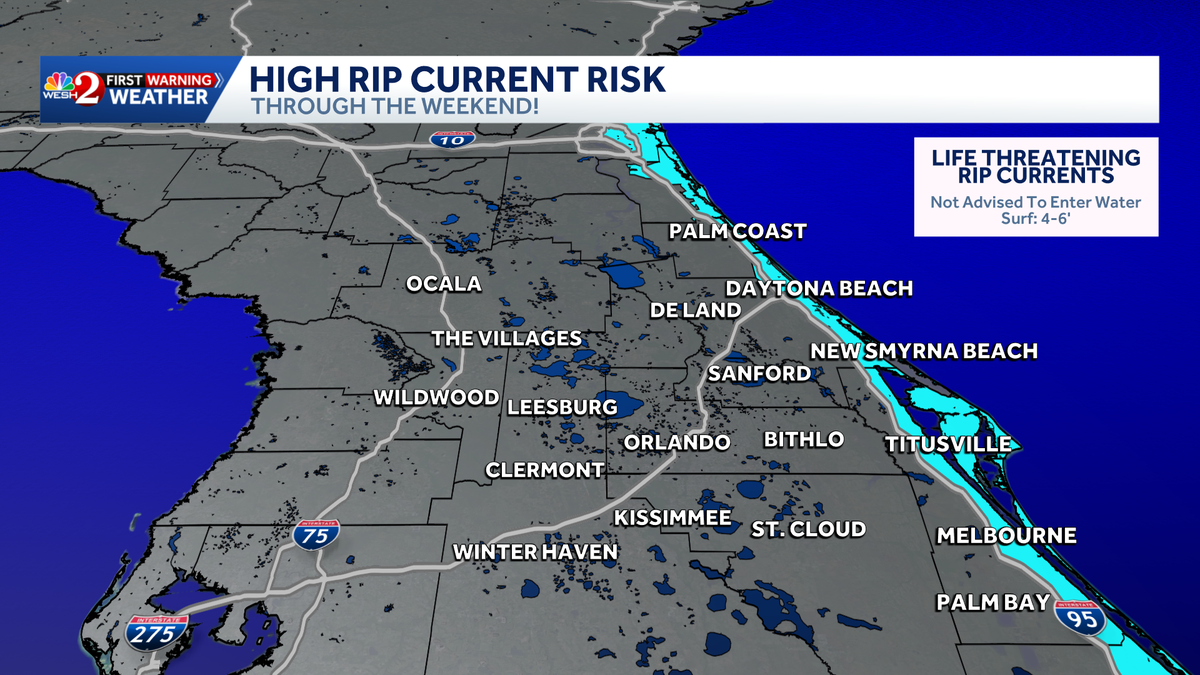
High rip current risk along Central Florida coast this weekend

Updated: 7:20 AM EDT Mar 21, 2026
Once the morning fog clears, Central Florida is in for a beautiful weekend.Meteorologist Cam Tran says to expect plenty of sunshine and dry conditions, the perfect weather to get outside and enjoy.For beachgoers, however, a high risk of rip currents is expected along the east Central Florida coastline. A lingering easterly swell will make entering the surf dangerous at local beaches from Saturday through Sunday, and it is not advised to enter the water.What is a rip current?A rip current is a strong, narrow channel of water that flows away from the shore and can carry even experienced swimmers into deeper water, according to the National Oceanic and Atmospheric Administration.Rip current safety tipsBeach safety officials recommended the following survival techniques:First, signal for help by waving your hands to alert others that you are in trouble.Then, swim parallel to the shoreline until you no longer feel the pull of the current.Another option is to float on your back until you are free from the current and able to swim back to shore.Warm weather aheadTemperatures will gradually warm into the mid-80s starting Sunday and continuing into next week.A cold front is expected to arrive Tuesday, bringing rain to the area. Tran says the front will stall, keeping showers in the forecast through Thursday.Despite the rain, the front is not expected to bring a cooldown.
ORLANDO, Fla. —
Once the morning fog clears, Central Florida is in for a beautiful weekend.
Meteorologist Cam Tran says to expect plenty of sunshine and dry conditions, the perfect weather to get outside and enjoy.
For beachgoers, however, a high risk of rip currents is expected along the east Central Florida coastline.

A lingering easterly swell will make entering the surf dangerous at local beaches from Saturday through Sunday, and it is not advised to enter the water.
What is a rip current?
A rip current is a strong, narrow channel of water that flows away from the shore and can carry even experienced swimmers into deeper water, according to the National Oceanic and Atmospheric Administration.

From WESH
Here’s what you can do if you are ever caught in a rip current.
Rip current safety tips
Beach safety officials recommended the following survival techniques:
First, signal for help by waving your hands to alert others that you are in trouble.Then, swim parallel to the shoreline until you no longer feel the pull of the current.Another option is to float on your back until you are free from the current and able to swim back to shore.Warm weather ahead
Temperatures will gradually warm into the mid-80s starting Sunday and continuing into next week.

A cold front is expected to arrive Tuesday, bringing rain to the area. Tran says the front will stall, keeping showers in the forecast through Thursday.
Despite the rain, the front is not expected to bring a cooldown.