
TALLAHASSEE, Fla. (WCTV) – Warm and dry weather will dominate the Tallahassee area through at least midweek.
You can watch First Alert Daily Weekend Edition around 10 A.M. for more weather below:⬇️
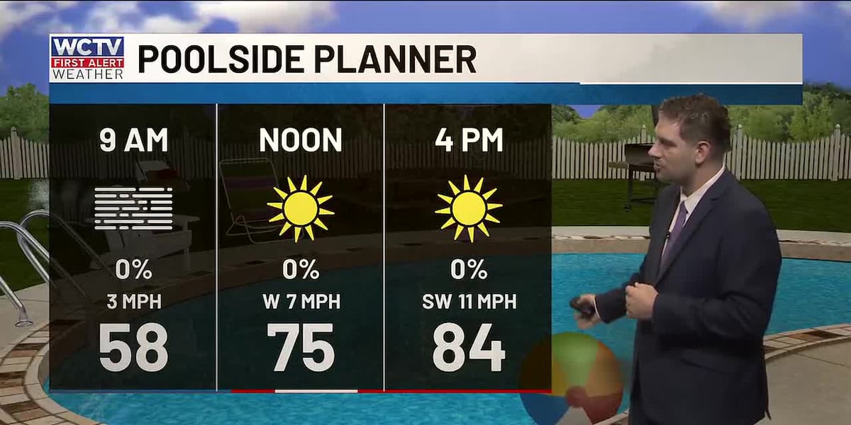
A foggy and mild beginning to our Sunday. Take it slow as you head to church and get ready to run those Sunday errands.
After morning fog clears by mid-morning Sunday, conditions will remain hazy but warm, with afternoon highs in the low to mid 80s. Coastal areas will be slightly cooler, reaching the mid to upper 70s. Overnight lows will settle in the mid to upper 50s, with near 60 degrees along the beaches.
Good boating conditions with winds SW between 5 and 15 knots. Waves 1 foot or less and a light chop on the protected waters and bays.
Air Quality Concerns
Smoke and haze from several wildfires will continue to impact the region, particularly during late afternoon and evening hours when air quality may be poorest.
Similar Pattern Monday, Then a Change
Monday will bring more of the same. It will be warm, dry and hazy with highs again in the low to mid-80s. However, a cold front will approach from the north Monday night into Tuesday, potentially squeezing out a couple of isolated showers, mainly over Georgia and Big Bend counties. Rain chances remain low at around 20%.
Temperatures will cool noticeably on Tuesday as easterly winds develop, with highs in the mid to upper 70s.
Cloudy skies continue on Wednesday
The 80s are back late week
After the brief cool-down on Tuesday and Wednesday, warmth will return by late in the week. Highs will climb back to the mid to upper 80s by Friday, with another frontal system moving through Friday night into Saturday. However, little moisture is expected with this system, so significant rainfall is unlikely.
Drought remains the main concern
With little to no rain expected over the next seven days, severe to exceptional drought conditions will continue or worsen across the region. The lack of rainfall is the primary weather concern for the area.
For those planning beach visits, be aware of current beach flag conditions and rip current risks, as warm and fair weather is expected to make beaches attractive this weekend.
Track weather changes 24/7 with WCTV First Alert Weather Now: ⬇️
To stay updated on all the latest forecasts and weather, follow WCTV First Alert Weather on Facebook and X (Twitter).
Click here to see all the latest weather headlines and here to view the First Alert Radar. Receive push alerts and watch the latest forecast anytime on the free WCTV First Alert Weather app. Click here to download it now.
Interested in becoming a WCTV First Alert Weather Watcher? Click here to join the team!
Copyright 2026 WCTV. All rights reserved.