
A strong cold front is expected to bring rain, gusty winds and dangerous surf to the Central Florida coast this weekend.WESH 2’s First Warning Weather Team has designated Saturday and Sunday as Impact Weather days due to the front’s powerful, gusty winds both inland and along the coast, creating dangerous beach conditions.Winds are expected to be between 15 and 25 mph, with gusts up to 40 mph.Watches and warningsAccording to the National Weather Service (NWS), a Gale Warning begins at 11 a.m. Saturday for Volusia County waters and will expand to Brevard County waters at 2 p.m.The marine alert is issued for strong, potentially dangerous winds of about 39 to 54 mph that are occurring or expected over the water.There is also a high risk of rip currents, as a High Surf Advisory goes into effect Saturday afternoon and continues through Sunday.Looking aheadPersistent onshore winds will keep a chance of showers in the forecast each day this week, though no single day is expected to be a washout.Cooler temperatures are expected behind the front Sunday and Monday before a gradual warm up this week.What is Impact Weather?Impact Weather suggests weather conditions could be disruptive or a nuisance for travel and day-to-day activities.DOWNLOAD the free WESH 2 News app for your latest news and alerts on breaking news, weather, sports, entertainment and more on your phone or tablet. And check out the Very Local app to stream news, entertainment and original programming on your TV.
ORLANDO, Fla. —
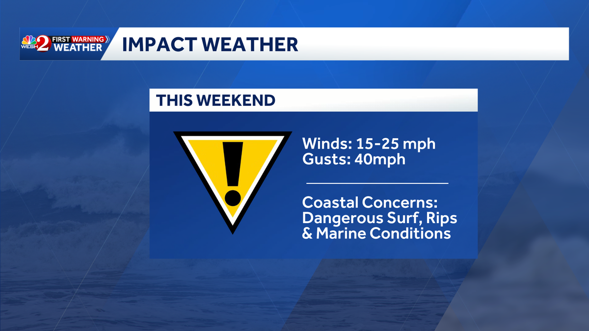
A strong cold front is expected to bring rain, gusty winds and dangerous surf to the Central Florida coast this weekend.
WESH 2’s First Warning Weather Team has designated Saturday and Sunday as Impact Weather days due to the front’s powerful, gusty winds both inland and along the coast, creating dangerous beach conditions.
Winds are expected to be between 15 and 25 mph, with gusts up to 40 mph.

Watches and warnings
According to the National Weather Service (NWS), a Gale Warning begins at 11 a.m. Saturday for Volusia County waters and will expand to Brevard County waters at 2 p.m.
This content is imported from Twitter.
You may be able to find the same content in another format, or you may be able to find more information, at their web site.
The marine alert is issued for strong, potentially dangerous winds of about 39 to 54 mph that are occurring or expected over the water.
There is also a high risk of rip currents, as a High Surf Advisory goes into effect Saturday afternoon and continues through Sunday.
Looking ahead
Persistent onshore winds will keep a chance of showers in the forecast each day this week, though no single day is expected to be a washout.

Cooler temperatures are expected behind the front Sunday and Monday before a gradual warm up this week.
What is Impact Weather?
Impact Weather suggests weather conditions could be disruptive or a nuisance for travel and day-to-day activities.
DOWNLOAD the free WESH 2 News app for your latest news and alerts on breaking news, weather, sports, entertainment and more on your phone or tablet. And check out the Very Local app to stream news, entertainment and original programming on your TV.